Kongsberg Geospatial

Geospatial Software for Real-Time Mapping, Data Visualization & Situational Awareness

Canada
Kongsberg Geospatial
Geospatial Software for Real-Time Mapping, Data Visualization & Situational Awareness
Kongsberg Geospatial Ltd. 411 Legget Drive, Suite 400 Ottawa, ON K2K 3C9 Canada Canada Regional offices
+1-613-271-5500.

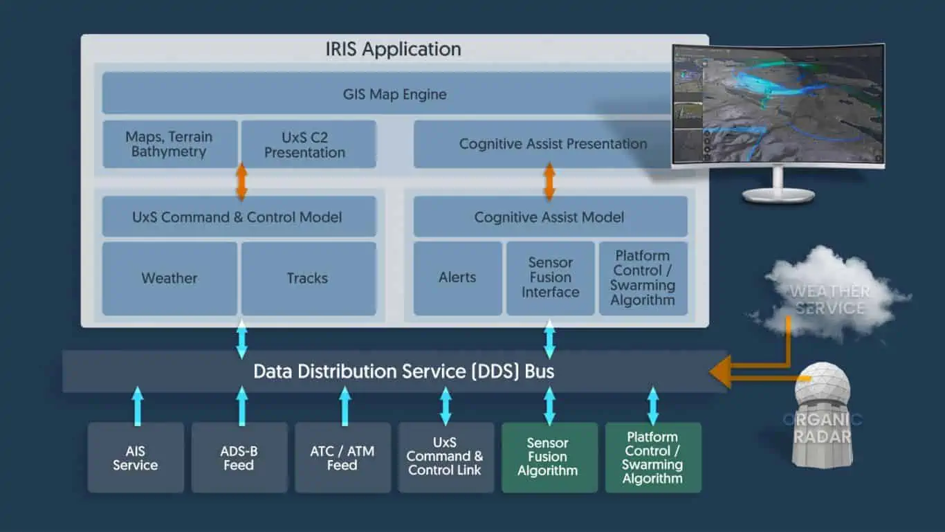
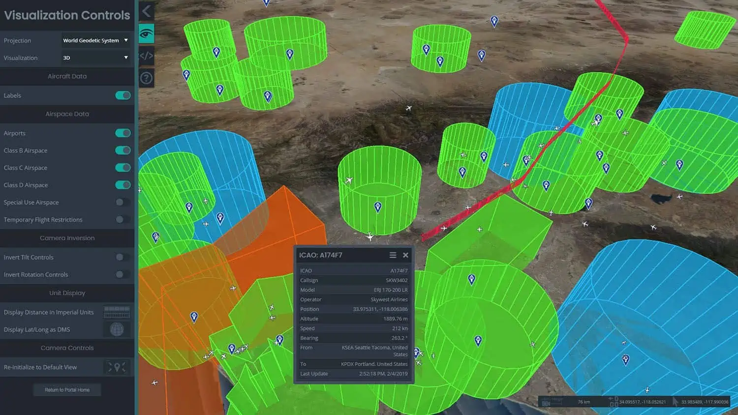
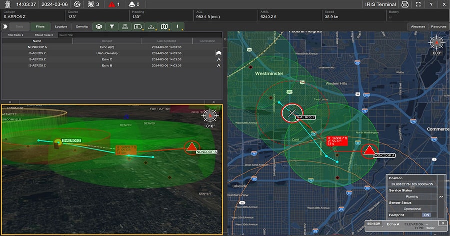
Kongsberg Geospatial is a leading developer of mission-critical software applications that provide mapping capabilities, geospatial data visualization, and situational awareness for UAVs (unmanned aerial vehicles) and uncrewed systems.

Geospatial Intelligence and airspace situational awareness

Our high-performance geospatial solutions enable the next generation of civilian and military BVLOS (beyond visual line of sight) drone missions, and also provide UTM (unmanned traffic management) and airspace awareness for integrating UAVs into civilian airspace.

IRIS Terminal

Enterprise airspace visualization for BVLOS UAS operators

IRIS Terminal is a real-time airspace visualization platform for enterprise UAS operators or UAS test sites operating BVLOS. Utilizing real-time cooperative and non-cooperative data sources such as ADS-B, RADAR, EOIR sensors, TASA sensors, AIS sensors and ownship telemetry, IRIS Terminal provides a true airspace picture of the operating theater in one ‘plane of glass’.

IRIS Terminal Airspace visualization software

Simultaneously our collision avoidance service computes the projected flight path of all detected aircraft, correlates duplicate tracks and alerts the operator in case of potential airspace conflict or loss of separation. An optional web-based component (IRIS Webviewer) allows operators to share real-time updates and tracks with team members in the field on their LTE enabled tablet.

More information: IRIS Terminal

IRIS GCS

Ground control software for BVLOS UAS fleets

real time situational awarenessIRIS GCS is a full-featured ground control station software package that delivers enhanced real-time situational awareness for UAVs operating beyond visual line of sight (BVLOS), and is also ideal for USVs (unmanned surface vessels) and UUVs (unmanned underwater vessels).

Providing the ability to track multiple vehicles in real time, IRIS GCS integrates 2D and 3D map and terrain data, aeronautical information, data from sensors, cameras and drone telemetry, as well as ATM/UTM (air/unmanned traffic management) data feeds.

IRIS UxS situational awareness software

More information: IRIS GCS

TerraLens

Geospatial software development kit

Geospatial software development kitTerraLens is a powerful software development kit (SDK) that allows users to easily create real-time 2D and 3D GIS (geographic information system) mapping and geospatial data visualization applications. The software allows developers to layer map data with multiple sources of geospatial data, including real-time data feeds, databases, maps and images.

Providing the most important features and capabilities without the need to develop a new display framework from scratch, TerraLens allows applications to be deployed to a wide variety of platforms, operating systems, and form factors.

More TerraLens products:

TerraLens Server

Map server for TerraLens applications

TerraLens Map ServerTerraLens Server is a versatile multiformat map server that delivers vector and raster map tiles and is optimized for use with TerraLens SDK-created applications. It also handles a wide array of terrain GIS data and vector formats, and includes an integrated MIL-SPEC 2525C symbol server.

TerraLens Server is ideal for a variety of UAV C2 (command and control) and military ISR (intelligence, surveillance, and reconnaissance) applications.

More information: TerraLens Server

TerraLens UI

Application framework for professional user interface creation

The TerraLens UI application framework allows developers to quickly prototype and build professional-looking and user-friendly interfaces for real-time geospatial visualization software.

geospatial data visualization softwareBased on the powerful QML markup language and built on the TerraLens library, the framework enables the creation of user displays that can accommodate an almost unlimited number of sensor inputs, video feeds, maps, and documents in a single viewport.

More information: TerraLens UI

TerraLens 3DWeb

Geospatial engine for browser-based applications

3d visualization softwareThe TerraLens 3DWeb JavaScript library allows developers to create powerful browser-based real-time data visualization applications. It uses the same shader-based rendering technology developed for the TerraLens geospatial visualization engine, allowing visualization of 3D terrain, vector tile data, and high resolution raster data.

Applications created with TerraLens 3DWeb can be deployed to multiple platforms and operating systems, including mobile devices, without the need for recompilation. The geospatial engine is ideal for mission-critical and military UAV applications such as C2 and airspace situational awareness.

More information: TerraLens 3DWeb

TerraLens Mobile

Geospatial SDK for mobile Android devices

TerraLens Mobile is a geospatial development platform specifically designed for rapid development and deployment on mobile Android devices. Enabling deep integration with the Android OS, it provides access to a wide range of low-level device functions such as the power system, camera, compass, and GPS.

More information: TerraLens Mobile

TerraLens Creator

Advanced map deployment and packaging toolkit

gis data managementTerraLens Creator allows users to quickly collate all map data and assets for a chosen geographical area or operational theatre in order to create convenient application packages and mission packs with maps at a desired level of detail.

Users can also fully customize map presentation and styling, add custom markups and symbols, and define multiple themes or configurations for each map such as day and night versions.

More information: TerraLens Creator

More information: TerraLens – Geospatial Data Visualization Platform

MDCS

Multi-domain C2 for unmanned systems

Multi-domain C2 for unmanned systems

MDCS provides multi-domain command and control for unmanned systems operating on land, at sea and in the air. Designed for army and naval UAVs, UGVs, USVs and UUVs, the software provides an intuitive integrated picture of a large number of tracks at a wide range of altitudes and depths and moving at very different speeds.

More information: MDCS

I-Sim

High-fidelity airspace and ATM simulator

I-SIM is a high-fidelity radar simulation system that is ideal for supporting UAS integration into civil airspace. Supporting both en-route and terminal operations, the system is delivered with fully-functional ERAM and ARTS/STARS display applications.

More information: I-SIM

Articles
+ Load More Articles
Webinars
On Demand
Future-Proofing Your Airspace Visualisation

March 13, 2023 - Available On Demand
On Demand
Sensor Fusion Visualized for the Operator in a Complex Multi-sensor World

November 9, 2022 - Available On Demand
On Demand
“See the Big Picture” – Remote Operations Center Control of Your Airspace & Aircraft While Managing Contingencies within One Software Application

September 20, 2022 - Available On Demand
Regional Offices & Locations
Canada (Head Office) Canada Kongsberg Geospatial Ltd. 411 Legget Drive, Suite 400 Ottawa, ON K2K 3C9 Canada Contact Website
United States United States of America Kongsberg Geospatial Corporation 1725 Duke Street, Suite 600, Alexandria, VA 22314, USA Website