


In this article, Kongsberg Geospatial explains how its TerraLens geospatial and display Software Development Kit (SDK) can help users map in real-time in 2D and 3D and visualize data in powerful ways.
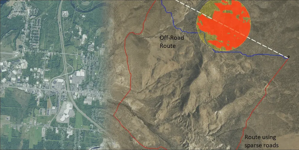
Most people are familiar with mapping apps or GPS devices that allow them to plan routes from one location to another, but they all rely on road networks to compute a route. When operating in areas with limited roads what do you need to consider when planning a route?
Considerations When Planning a Route
The first thing to consider is the capabilities of the vehicle because all other aspects of route planning will depend on the vehicle’s characteristics.
The cross-country capabilities of vehicles, both manned and unmanned, will vary significantly. Size, weight, weight distribution, engine power, and wheeled versus tracked are all factors that play a role in determining how well if at all, a vehicle can traverse any given terrain.
Knowing the physical terrain is essential to planning an effective route. Terrain elevation can affect a vehicle’s engine performance, and its slope and roughness will dictate regions that cannot be traveled over. Soil type and moisture content will affect traction and can be used to identify areas to avoid and areas to prefer. Terrain features like dense forests, lakes, and rivers introduce natural obstacles that must be routed around. A priori knowledge of the terrain will aid in planning but local conditions can change rapidly and must be accommodated, for instance in response to weather conditions.
Tactical Environment: A Key Point
In addition to the physical terrain, knowing the tactical environment will allow route planning to minimize the potential negative effects of obstacles and threats.
For military operations, some examples of obstacles to maneuvering would be minefields, dense urban areas, artillery cratering, and threats like enemy vehicles, observation posts, or areas with known enemy activity. Furthermore, since many of the elements in the tactical environment are not static, your route planning can be both reactive and proactive depending on the level of situational awareness.
Now that you know your environment, where would you like to go?
About TerraLens:
In virtually any development environment, TerraLens is an easy-to-integrate and quick-to-implement geospatial and display Software Development Kit (SDK).
With TerraLens, you can map in real-time in 2D and 3D and visualize data in powerful ways. When combined with QT, TerraLens offers advanced multi-touch support as well as a full-featured UI development toolset.
Try TerraLens for Free:
Learn more about our TerraLens Software Development Kit and how you can acquire a free TerraLens Developer License.


