Geospatial Analysis Software and GIS for Mapping and Data Insights
Category Presented by
Geospatial analysis is the process of collecting, interpreting, and visualizing geographic data to understand spatial patterns, relationships, and trends. It plays a vital role in industries such as urban planning, environmental monitoring, disaster response, agriculture, and defense. Using geographic information systems (GIS), mapping applications, and advanced geospatial analysis software, organizations can make data-driven decisions based on real-world spatial insights.
Unmanned systems, such as drones and autonomous sensors, have enhanced geospatial analysis by improving data collection speed and accuracy. At the same time, geospatial analysis contributes to better navigation, situational awareness, and decision-making for autonomous systems. This category explores the core aspects of geospatial analysis, its applications, and the role of GIS software in mapping and spatial data processing.
If you design, build or supply Geospatial Analysis Software, create a profile to showcase your capabilities and connect with visitors who have an active requirement for your solutions.
... is a powerful software development kit (SDK) that enables users to easily create professional... ...ray of terrain data and vector formats, TerraLens Server also includes an integrated MIL-SPEC 2525C...
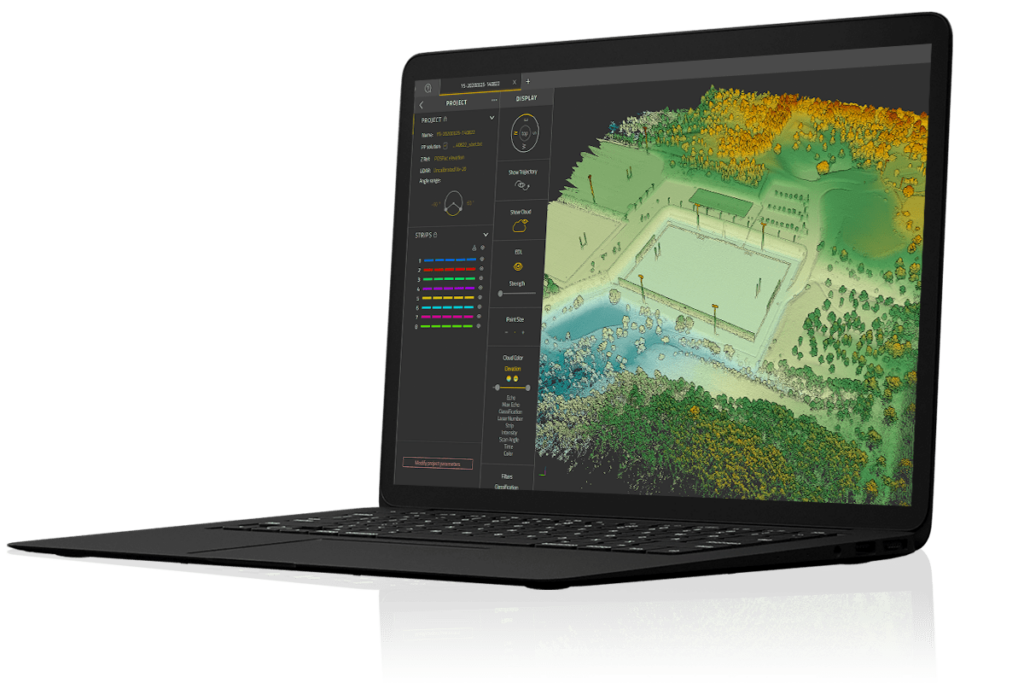
...he proprietary software developed by YellowScan to generate and visualize point-clouds. An... Our software provides you with auto-detection of strips, in-depth configuration and LAS files...
...ic point cloud data captured by drones. Incorporating all of the point cloud processing... ...of point cloud data including ground, vegetation, buildings, power lines, and poles...
...ate-of-the-art GISsoftware package that provides comprehensive geospatialdataanalysis and... The software is also designed for easy visualizing, editing, and analysis of LiDAR or point cloud...
Geospatial Analysis Software and GIS for Mapping and Data Insights
Overview by
Sarah Simpson
Updated:
What is Geospatial Analysis?
Geospatial analysis involves processing and analyzing data tied to specific geographic locations. This includes the use of GIS mapping, remote sensing, and spatial modeling to extract insights from geographic information. The data is typically collected through satellite imagery, LiDAR scans, aerial photography, and GPS systems.
The results of geospatial analysis are used for a wide range of applications, from creating highly detailed maps to performing predictive modeling for environmental changes. By using GIS platforms and geospatial databases, analysts can track geographic patterns, monitor resources, and optimize land use planning.
Key Applications of Geospatial Analysis
Geospatial analysis plays a fundamental role in various fields, enabling better decision-making and resource management:
Urban planning & smart cities
City planners and engineers use GIS mapping software and geospatial databases to design efficient infrastructure, manage transportation networks, and optimize land use. Smart city initiatives rely on spatial analysis and big data to improve traffic management, energy distribution, and environmental sustainability.
Environmental monitoring & conservation
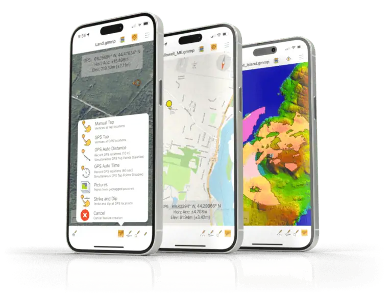
Global Mapper Mobile by Blue Marble Geographics
Geospatial analysis helps scientists track deforestation, study climate change, and monitor wildlife habitats. Remote sensing software and GIS services enable real-time monitoring of air and water quality, supporting conservation efforts worldwide.
Disaster management & risk assessment
Predictive modeling and spatial analysis are essential for disaster preparedness and response. GIS mapping software helps emergency teams assess risk areas, map evacuation routes, and coordinate relief efforts. UAV mapping software allows drones to capture post-disaster imagery for rapid damage assessment.
Precision agriculture and farming
Farmers and agricultural scientists use GIS platforms and drone mapping software with agricultural drones to monitor crop health, analyze soil conditions, and optimize irrigation. By leveraging geospatial solutions, precision agriculture improves yield predictions and reduces resource waste.
Surveying and land management
Surveyors and cartographers rely on geospatial analysis to create high-accuracy maps, assess land use, and conduct topographic studies. GIS mapping software and drone photogrammetry tools enable the development of 2D and 3D visualizations for real estate, construction, and natural resource management.
Security, surveillance and defense
Geospatial analytics software enhances situational awareness for defense and security operations. Law enforcement agencies use geospatial databases and GIS mapping tools for crime mapping, threat detection, and surveillance planning. Military applications include mission planning, border security, and reconnaissance operations.
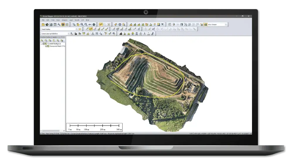
Geospatial data analysis and GIS mapping software by Blue Marble Geographics
Geospatial Analysis Techniques and Technologies
A variety of geospatial analysis techniques help organizations derive insights from geographic data:
Spatial analysis – Identifies spatial relationships and trends, used in urban planning and logistics.
Network analysis – Optimizes routes and transportation systems, vital for supply chain management and emergency response.
Cluster analysis – Detects geographic patterns, such as disease outbreaks or population distribution.
Proximity analysis – Evaluates distances and spatial relationships, used in disaster response and land-use planning.
Predictive modeling – Uses historical geospatial data to forecast environmental and economic changes.
Geospatial Software and Tools
Advanced GIS software and mapping platforms process and visualize geospatial data:
How Unmanned Systems Contribute to and Benefit from Geospatial Analysis
YellowScan CloudStation LiDAR Point Cloud Processing Software
Unmanned systems, particularly drones and autonomous sensors, play a growing role in geospatial data collection. These systems enhance traditional mapping and surveying by providing real-time, high-resolution imagery and LiDAR scans. Drones equipped with geospatial mapping software can cover vast areas quickly, capturing critical data for agriculture, infrastructure monitoring, and disaster response.
At the same time, geospatial analysis supports unmanned systems by improving navigation, situational awareness, and operational planning. Autonomous vehicles rely on GIS mapping, GPS data, and geospatial databases to operate efficiently in complex environments. From UAV route optimization to AI-driven terrain analysis, geospatial intelligence is essential for the advancement of unmanned technologies.
The Future of Geospatial Analysis
With the rise of AI, big data, and cloud-based GIS platforms, geospatial analysis is becoming more powerful and accessible. Machine learning algorithms enhance predictive modeling, while real-time geospatial analytics drive faster decision-making in industries such as transportation, environmental science, and security. The increasing integration of unmanned systems into geospatial data collection and analysis will continue to push the boundaries of mapping technology and spatial intelligence.
As organizations across various sectors harness the power of geospatial analysis, its impact on global decision-making and resource management will only grow. Whether used for urban development, environmental protection, or precision farming, geospatial analysis remains at the forefront of innovation in mapping and geographic intelligence.
Blue Nose Aerial Imaging outlines the core principles of drone mapping, explaining how photogrammetry and LiDAR workflows are used to generate accurate geospatial deliverables for analysis and decision-making
Blue Marble Geographics has launched Global Mapper 27, integrating the GeoCalc geodetic library as a standard feature alongside enhancements to LiDAR validation, automated terrain modeling, and expanded geospatial data format support
Theta Informatics LLC enters a Cooperative Research and Development Agreement with the U.S. Army Combat Capabilities Development Command Army Research Laboratory to conduct research under “Vision-Based Target Localization"
Blue Marble Geographics highlights its Online Classroom, featuring new self-paced courses in point cloud processing that cover core workflows, feature extraction, and advanced analysis using Global Mapper tools
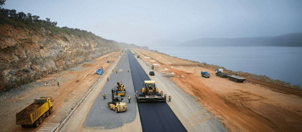
Blue Marble Geographics details how PT Waskita Karya (Persero) Tbk is using drone-based photogrammetry and watershed analysis within Global Mapper® to support environmentally responsible design and risk mitigation for a road project in Indonesia
Blue Marble Geographics’ Global Mapper provides a comprehensive set of visualization features that enhance the way users analyze, animate, and interpret geospatial information
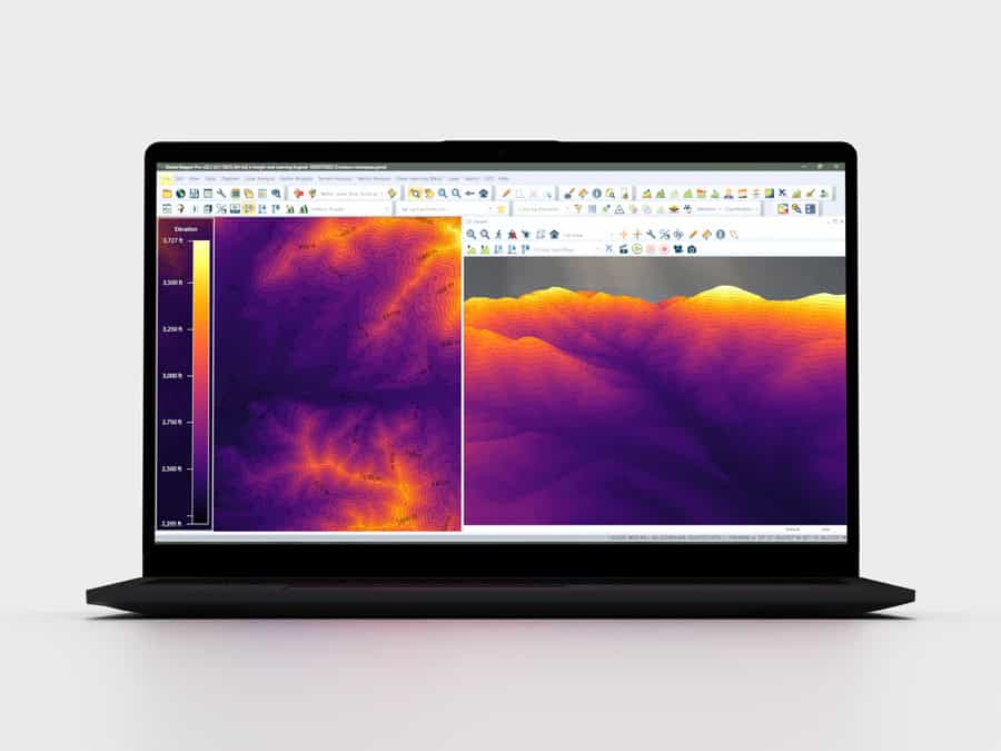
Blue Marble Geographics outlines how Global Mapper Pro processes lidar point clouds, creates detailed elevation models, and extracts railroad tracks through breakline analysis to support dependable interpretation of rail corridors
Blue Marble Geographics’ Global Mapper software is used by Egis teams to process LiDAR and topographic data, create 3D terrain models, and perform hydrological analyses for environmental and hydraulic projects
Nov 25, 2025
Advancing Unmanned Systems Through Strategic Collaboration
UST works with major OEMs to foster collaboration and increase engagement with SMEs, to accelerate innovation and drive unmanned systems capabilities forward.