Blue Marble Geographics

verified This business has been claimed by Blue Marble Geographics and verified by UST.
Verified companies work with us to ensure we display the most up-to-date and comprehensive product information, articles and other material to help you choose the right solution for your requirements.
Geospatial Data Analysis, Point Cloud Processing and GIS Mapping Software for Drones and UAV United States of America
Visit Website
Saved
Save
Contact
Blue Marble Geographics

Geospatial Data Analysis, Point Cloud Processing and GIS Mapping Software for Drones and UAV

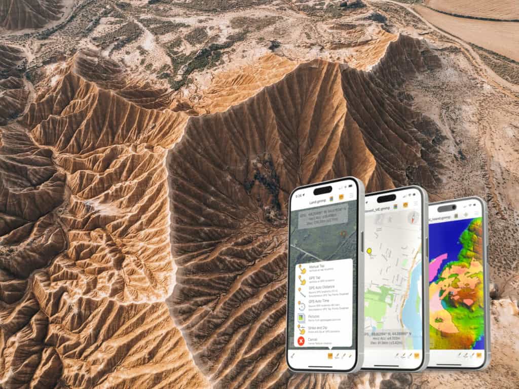
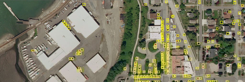
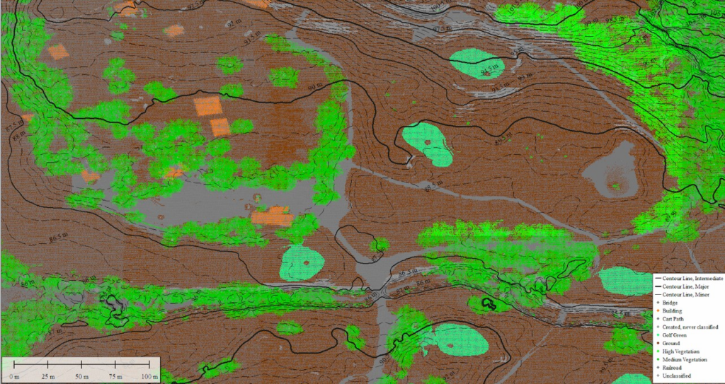
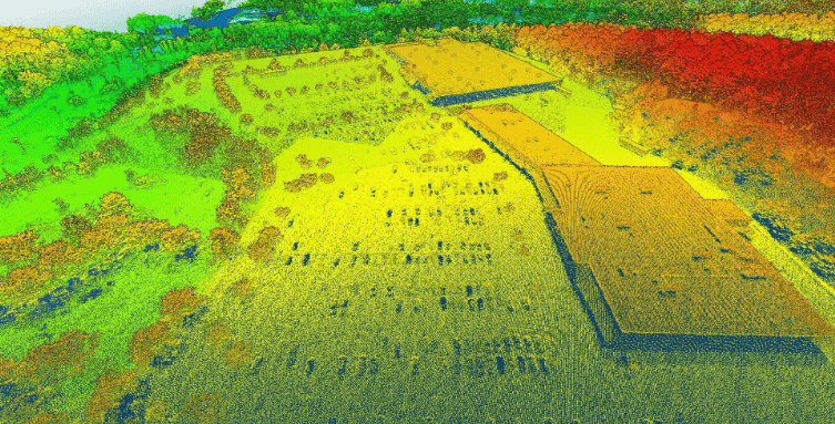
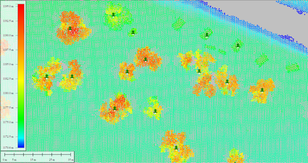
Blue Marble Geographics is a leading developer of state-of-the-art software solutions for geospatial professionals. Utilized by leading organizations and government agencies around the world, our products are ideal for comprehensive editing and processing of GIS data as well as photogrammetric and LiDAR point cloud data captured by drones and UAVs (unmanned aerial vehicles).

gis mapping software

Global Mapper

Geospatial data analysis and GIS mapping software

Global Mapper is a state-of-the-art GIS software package that provides comprehensive geospatial data analysis and processing capabilities for novice and experienced geospatial professionals alike. With a highly intuitive user interface and powerful tools, it delivers efficient data processing and management and accurate map creation and is ideal for organizations of any size.GlobalMapper geospatial data analysis

Global Mapper supports over 300 raster, vector, and elevation data types, including common file formats as well as proprietary types, allowing users to get to work right out of the box. The built-in online data function includes direct links to a variety of data services, including one-meter aerial imagery for the U.S., worldwide elevation data, topographic maps, Landsat satellite imagery, and more.

GlobalMapper point cloud processing

Point Cloud Processing

The software is also designed for easy visualizing, editing, and analysis of LiDAR or point cloud data of any format. Enhanced rendering and processing speeds allow users to utilize data from point clouds of almost any size efficiently and effectively. Global Mapper provides access to point cloud file attributes, providing a critical snapshot of essential information for your data processing workflow.GlobalMapper GIS analysis

Other advanced features of Global Mapper include:

  • Powerful terrain analysis tools for processing and modelling elevation data
  • Support for recording HD 3D fly-through videos for powerful visualization of 3D projects
  • Reading and writing data from common spatial databases including Esri, MSSQL, MySQL, Oracle, PostGIS/PostgreSQL and SpatiaLite/SQLite
  • Geocoding function that allows real-world coordinates to be assigned to an imported database of addresses
  • Raster Calculator for multi-band imagery such as NDVI and NDWI
  • Objective Terrain Format (OTF) Reader Module for military mapping

More information: Global Mapper

Global Mapper Pro

LiDAR and photogrammetric processing and editing

Photogrammetry Software
Global Mapper Pro builds on the base functionality of Global Mapper with a variety of powerful professional tools for editing and processing LiDAR and photogrammetric point cloud data captured by drones. Incorporating all of the point cloud processing functionality available in Global Mapper’s Lidar Module, Global Mapper Pro adds an extensive array of features that perfectly complement and expand the existing software capabilities.

Global Mapper Pro geospatial tools

Global Mapper Pro spatial data analysis

New features available in Global Mapper Pro include:

  • Terrain painting
  • Advanced querying, editing, segmenting, and filtering of LiDAR and 3D point clouds
  • Automatic classification of point cloud data including ground, vegetation, buildings, power lines, and poles
  • Vector feature extraction from classified point cloud data
  • LiDAR noise identification and removal
  • Automatic alignment of overlapping point clouds
  • Visual data analysis of point cloud data, including by local density, height above ground, intensity, and classification
  • Pixels to Points – UAV imagery processing for creation of 3D point clouds, orthoimages, and 3D models
  • Support for RTK devices and display of satellite constellation
  • Support for Python scripting

More information: Global Mapper Pro

Pixels to Points

Pixels to Points is a photogrammetric processing tool within Global Mapper Pro that uses overlapping drone/UAV images to create photo-textured 3D models, orthoimages, and high-resolution point clouds. These generated data models can then be used in Global Mapper to measure terrain volume, asses structures, create detailed base maps, and more.

pixels to points image processing tool

Global Mapper Insight and Learning Engineâ„¢ (beta)

New deep learning-powered image analysis toolset for object detection and land cover classification

The Global Mapper Insight and Learning Engineâ„¢ (beta) is a deep learning-powered image analysis toolset available to all Global Mapper Pro v26 users. This new suite of automated raster analysis tools provides trained models for land cover classification, vehicle identification, and building extraction. A fine-tuning option allows users to re-train layers of a model to improve the analysis results on specific datasets.

Geographic Calculator

Geodetic software for UAV surveying data

Geographic Calculator is a powerful geodetic software package that provides accurate coordinate conversion, datum transformation, and file translation. Incorporating the largest geodetic parameter database available anywhere, it is an essential tool for UAV surveying as well as for seismic data management and energy exploration.

geodetic software for UAV surveying

The intuitive Interactive Conversion feature allows users to select source and destination coordinate systems, enter the coordinates, choose the datum transformation and get results with the click of a button.

More information: Geographic Calculator

Global Mapper Mobile

Advanced mobile application for geospatial data management

Global Mapper MobileGlobal Mapper Mobile is a robust iOS and Android application designed for intuitive viewing, collection, and management of geospatial data. Perfectly suited for field professionals in industries like surveying, environmental analysis, and infrastructure development, the app offers seamless integration with Global Mapper desktop software.

By combining high-level data visualization tools with field-ready capabilities, Global Mapper Mobile streamlines workflows in environments where precision and flexibility are essential.

Applications

Architecture, Engineering & Construction

spatial data management for constructionGlobal Mapper helps engineers and surveyors to pre-plan earthwork projects and to maintain and extend infrastructure. The powerful GIS mapping software provides a variety of visualization tools for planning elements such as ramps for highways, ditches for stormwater runoff, and more.

spatial analysis in gisEnergy & Utilities

Our solutions are ideal for point cloud processing, providing visual data analysis from corridor inspections for powerlines and utilities, with the ability to extract and classify features such as encroaching vegetation from drone LiDAR data.

geospatial tools for Military & DefenseMilitary & Defense

Global Mapper provides the ability to easily view, edit and update mission-critical maps for situational awareness and navigation, keeping information relevant as situations, assets, and landscapes change.

Geospatial data analysis and 3D terrain modelling are also essential for developing accurate battlefield simulations that can be used to to train and equip personnel in unfamiliar territory.

Products

Global Mapper Mobile

Advanced mobile application for geospatial data management

Geographic Calculator

Geodetic software for UAV surveying data

Global Mapper Pro

LiDAR and photogrammetric processing and editing

Global Mapper

Geospatial data analysis and GIS mapping software

Articles

Latest
Improved Tools and Functionality in Global Mapper Pro v26.1

Global Mapper Pro v26.1 enhances data processing with improved lidar tools, refined vehicle detection, and expanded scripting capabilities, offering greater efficiency and precision in geospatial analysis

Mar 05, 2025
Blue Marble Releases Global Mapper v26.1 with Advanced GIS Tools and Vehicle Detection

Blue Marble’s Global Mapper® v26.1 introduces powerful new tools for data editing, deep-learning advancements, and model fine-tuning, enhancing vehicle detection, point cloud management, and user customization for GIS professionals

Feb 26, 2025
Explore Geospatial Tools with Blue Marble at XPONENTIAL Europe

Blue Marble Geographics will showcase advanced geospatial software at XPONENTIAL Europe 2025, featuring live demos of the Global Mapper Suite and advanced geospatial tools

Feb 14, 2025
New Features in Global Mapper SDK v26.0

Blue Marble Geographics has released Global Mapper SDK v26.0, featuring updated format support, faster drone image processing, and innovative solar analysis

Nov 05, 2024
Mastering Point Cloud Sub-Classifications with Global Mapper Pro

Blue Marble Geographics explores how Global Mapper Pro's latest features streamline the process of sub-classifying point clouds, enabling users to achieve higher levels of precision and efficiency in geospatial projects

Jul 02, 2024
Creating a Topographic Map from a Point Cloud

A topographic map can be created from a point cloud in Global Mapper Pro, learn how to create your own in the latest article from Blue Marble Geographics

Jun 03, 2024
Identifying Change in Tree Height with Global Mapper Pro

Blue Marble Geographics has released the v25.1 release of Global Mapper Pro, featuring an updated Compare Point Cloud tool that can be used for identifying changes in tree height by comparing point clouds to terrain

May 09, 2024
Exporting GIS data for 3D Printing: A Step-by-Step Guide

Blue Marble Geographics has released a step-by-step guide to 3D printing GIS data from its Global Mapper software, which exports large terrain and 3D files to a range of file types

Apr 09, 2024
New Tool to Automatically Identify & Mark Ground Control Points in Drone Imagery

Blue Marble Geographics details a new tool in Global Mapper Pro v25.1 that automatically identifies and marks Ground Control Points in images making the process faster and less time-consuming

Mar 14, 2024
Top New Features in Global Mapper v25.1 Pro

Blue Marble Geographics discusses the new features and improvements in Global Mapper v25.1 Pro, from creating subclassifications in point clouds, terrain painting within the path profile window, and automatic ground control point placement

Mar 06, 2024
Top New Features in Global Mapper v25.1 Standard

Global Mapper version 25.1 hillshade tool now boasts the ability to create shadows across the terrain layer based on location and time of day, the ability to crop a mesh feature, and receive location data from GNSS devices over TCP and UDP

Feb 29, 2024
Blue Marble Geographics Wins Outstanding Innovation in Lidar Award

Global Mapper Pro’s Custom Point Cloud Classification Training Tool has won the 2024 Lidar Leader: Outstanding Innovation in Lidar Award, for developing groundbreaking new functionality for training custom automatic point cloud classifications

Feb 26, 2024
Blue Marble’s Global Mapper GIS Application

Blue Marble discusses the features of its GIS application, Global Mapper, which has complete interoperability with impressive data support, as well as extensive raster and vector capabilities

Jan 17, 2024
Training a Custom Point Cloud Classification in Global Mapper Pro

Are you looking to create point cloud classifications to identify unique features in your point clouds? Learn more with Blue...

Dec 13, 2023
Top Pixels to Points Features in Global Mapper Pro

Blue Marble Geographics discusses the top five Pixels to Points features within Global Mapper Pro to improve processing

Nov 23, 2023
Updates to Point Cloud Analysis in Global Mapper Pro v25

In this article, Blue Marble Geographics details the Automatic Point Cloud Analysis tool in Global Mapper Pro v25, and discusses...

Oct 23, 2023
New Features in Global Mapper Pro Version 25

New features, tools, and improvements to Global Mapper Pro Version 25 include a new least-cost path analysis tool, multiple pixels to points improvements, and a new raster paint tool

Sep 20, 2023
Using External GNSS Devices with Global Mapper Mobile Pro

Mackenzie Mills from Blue Marble Geographics explains how to use external GNSS devices with Global Mapper Mobile Pro. Global Mapper...

Aug 15, 2023
Version 2.4 of Global Mapper Mobile Released

V2.4 adds many updates and improvements to the application, including a Line Trace Mode to easily digitize line features using a stylus and a new Raster Info tool to display pixel values for raster elevation or image data layers

Aug 07, 2023
The Difference Between Lidar and Photogrammetric Point Clouds in Global Mapper

In this article, Amanda Lind from Blue Marble Geographics explains the uses, advantages and differences of lidar and photogrammetric point...

Jul 19, 2023
Classifying Transmission Towers in Point Clouds Using Global Mapper Pro

In this article, Amanda Lind from Blue Marble Geographics describes the process of classifying transmission towers in point clouds using...

Jun 09, 2023
Extracting Curbs as Breaklines Using Global Mapper

Amanda Lind at Blue Marble Geographics explains the automated method of extracting curbs as line features from elevation data using Global Mapper. There...

May 18, 2023
Evaluating Distances Between Point Clouds Using Global Mapper Pro

Amanda Lind at Blue Marble Geographics explains how to use the Compare Point Clouds tool in the company’s Global Mapper...

Apr 20, 2023
Version 24.1 of the Global Mapper SDKs Include New Features & Updates

Both Software Development Kits (SDKs) allow developers to utilize functionality from Global Mapper in their own applications and create custom toolbars and extensions for the latest versions of Global Mapper

Apr 03, 2023
Classifying Power Poles in Point Clouds with Global Mapper 

In the article below, Amanda Lind from Blue Marble Geographics describes how Global Mapper’s new pole classification tool works, as...

Mar 21, 2023
Relative Elevation Models in Global Mapper

The latest Global Mapper release (v24.1) includes a new tool for creating Relative Elevation Models (REM), which are also referred to...

Mar 17, 2023
Chinese Language Version of Global Mapper GIS Software Released

The Chinese language version of Blue Marble Geographics’ Global Mapper 24.0 was developed in partnership with the company’s certified product distributor for China, Beijing E-Carto Technologies

Jan 03, 2023
Global Mapper Pro Version 24 Includes New Script Builder Tool

Blue Marble Geographics’ Global Mapper Pro v24 includes workflow optimization tools such as recorded script building, GPU-acceleration of Pixels to Points, and a tool for merging changes from Global Mapper Mobile field collected data

Oct 18, 2022
Drone-Collected Image Processing Using Global Mapper Pro v24

Global Mapper Pro’s Pixels to Points tool can take in a set of drone-collected images and surveyed control points available and reconstruct the scene in 3D using the Structure from Motion (SfM) process

Oct 04, 2022
TCP/IP GNSS Device Communication for Global Mapper Mobile

Blue Marble Geographics has released the following article highlighting the ability of its Global Mapper Mobile geospatial app to support...

Aug 02, 2022
Regional Offices & Locations
Blue Marble Geographics United States of America 22 Carriage Lane, Hallowell, Maine 04347 USA +1-207-622-4622 Contact Website
Advancing Unmanned Systems Through Strategic Collaboration UST works with major OEMs to foster collaboration and increase engagement with SMEs, to accelerate innovation and drive unmanned systems capabilities forward.