Improved Tools and Functionality in Global Mapper Pro v26.1
Global Mapper Pro v26.1 enhances data processing with improved lidar tools, refined vehicle detection, and expanded scripting capabilities, offering greater efficiency and precision in geospatial analysisblue-marble-geographicsNewsGeospatial Analysis Software / Feature Article by Blue Marble Geographics
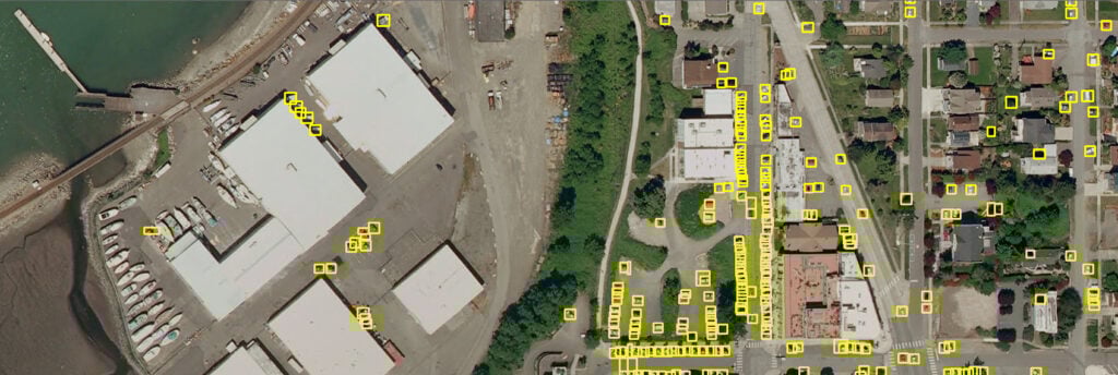
Vehicle Detection in the Insight and Learning Engine can now be fine-tuned.
Follow UST
Share this
Global Mapper Pro v26.1 from Blue Marble Geographics introduces a range of new features, including refined vehicle detection, updated point cloud classification, and enhanced scripting tools. This article outlines the key updates in this latest release. Read more >>
The updated toolbar stack enhances accessibility, while refinements to the Lidar QC tool and Pixels to Points functionality improve accuracy and efficiency. The toolbar stack has been modified to include a scripting toolbar and a streamlined lidar toolbar, both incorporating new tools. The Lidar QC tool now enables adjustments to utilized GCPs for improved calculation accuracy. Additionally, Pixels to Points® now supports three different Color Harmonization methods from openMVG.
Fine-Tuning for Vehicle Detection with the Global Mapper Insight and Learning Engine
Fine-tuning for vehicle detection is available through the Global Mapper Insight and Learning Engine™(beta), a deep learning-based image analysis toolset. This suite includes trained models for land cover classification, vehicle detection, and building extraction.
The fine-tuning capability allows layers of a model to be re-trained for improved analysis results on specific datasets. In version 26.1, fine-tuning and training support have been extended to vehicle detection, enabling users to incorporate their own truth data to refine models. Other modifications include improved handling of canceled training data, allowing the reuse of the same experiment name.
Ease-of-Use Updates in the Scripting Toolbar
A new scripting toolbar has been implemented to provide direct access to the Script Builder, Script Editor, and a new Favorite Scripts function.
The Favorite Script Manager enables listing frequently used scripts for easy execution. Running a tool or workflow can be accomplished by selecting a script from the dropdown menu and clicking the run button. Scripting functionality is also present in the standard version of Global Mapper, with some limitations.
Blue Marble Geographic offers an Online Training Course, for those interested in learning how to script workflows in Global Mapper: Principles of Global Mapper Scripting
Configuration Settings for the Insight and Learning Engine
A dedicated configuration dialog has been introduced to facilitate control over models, including downloading, sharing, and updating. Built-in models for building and vehicle detection, provided by Blue Marble Geographics, require separate downloads due to file size. Updates to these models are periodically released and are now accessible for download within the Configuration menu in version 26.1.
Favorite Script Manager
The Favorite Scripts Manager stores chosen Global Mapper scripts for ease of use.
The Favorite Scripts Manager, accessible from the Scripting toolbar or Tools menu, offers an organized interface for managing frequently used scripts. Compatible with both Global Mapper and Python, scripts can be saved within the Favorite Scripts menu for execution at any time.
Once added to the favorites list, a copy of the script is stored in the Global Mapper library, separate from the original file. Tools within the Favorite Scripts feature enable script management and workflow optimization.
Streamlined Lidar Tools
Point cloud tools have been consolidated into a single lidar toolbar, replacing previously separate toolbars. This newly structured toolbar groups tools based on function, organizing them into dropdown menus for Classification and Selection.
The previously used Manual Classification toolbar can still be enabled from the View menu, but its buttons have been integrated into the new Manual Classification toolset.
New Lidar Manual Classification Toolset
The Manual Classification toolset now includes all manual classification buttons in one location. A new “unclassified” classification button has been added, along with the ability to specify additional classes through a dropdown menu. Additional classifications can be created using the Custom Classification tool or through the Lidar tab in configuration.
All existing and new manual classification buttons are included in the Manual Classification tool.
The Manual Classification tool supports a lidar edit mode, allowing the assigned class to be applied to any selected points while in editing mode. This eliminates the need for hotkeys and facilitates continuous editing.
With the separate selection functionality, multiple tools can be used simultaneously, such as enabling the digitizer in the Manual Classification tool alongside the Path Profile tool or the Select by Area tool within the Path Profile window. If incorrect points are classified, the Undo function (Ctrl + Z) can be used to reverse changes.
Classify Power Lines using the Maximum Likelihood Method
The Maximum Likelihood classification method has been added for power line classification. This approach uses geometric segmentation to determine the most probable classification of a feature. The Maximum Likelihood method can identify linear segments within point clouds, providing improved differentiation between powerlines and surrounding vegetation.
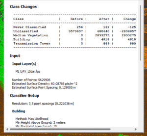
Point Cloud Reports
Version 26.1 includes an option to save classification settings for future use and generate summary reports of automatic point cloud processing results. When enabled, a text summary of the classification process will be displayed upon completion within Global Mapper and saved to a specified location.
Additionally, a .JSON file is created, which can be reimported by selecting the Enable Custom Feature Models option and using the Load Models button to navigate to the file.
This provides a method of saving your settings to apply to another workspace or in the future, without having to translate them into a script file.
Posted bySummer JamesSummer is an Editor & Copywriter at Unmanned Systems Technology. She joined in 2025, following a background in Creative Writing and English Literature, and has a strong interest in UAVs as well as imaging and vision systems. Her work centers on making complex technical advances in unmanned systems accessible to a broad audience.Connect
Blue Marble Geographics has launched Global Mapper 27, integrating the GeoCalc geodetic library as a standard feature alongside enhancements to LiDAR validation, automated terrain modeling, and expanded geospatial data format support
Blue Marble Geographics' latest update to GIS software focuses on efficiency, enhanced data display, and broader file format compatibility including Phase One's IIQ
Blue Marble’s Global Mapper® v26.1 introduces powerful new tools for data editing, deep-learning advancements, and model fine-tuning, enhancing vehicle detection, point cloud management, and user customization for GIS professionals
Blue Marble Geographics will showcase advanced geospatial software at XPONENTIAL Europe 2025, featuring live demos of the Global Mapper Suite and advanced geospatial tools
Blue Marble Geographics has released Global Mapper SDK v26.0, featuring updated format support, faster drone image processing, and innovative solar analysis
Nov 05, 2024
Advancing Unmanned Systems Through Strategic Collaboration
UST works with major OEMs to foster collaboration and increase engagement with SMEs, to accelerate innovation and drive unmanned systems capabilities forward.