


Blue Marble Geographics has released the Global Mapper® v26.1, the winter update to Global Mapper featuring highly requested preset configurability, refinements to point cloud processing, and deep-learning advancements.
Global Mapper is an all-in-one GIS software solution designed with accessibility and user feedback in mind. The standard version provides essential tools for vector, raster, and terrain analysis, making it a powerful GIS platform for a wide range of users. For those needing advanced geospatial capabilities, Global Mapper Pro® extends these tools with enhanced photogrammetry, terrain painting, and lidar analysis (including automatic cloud classification and feature extraction) along with Python scripting and more.

Global Mapper version 26.1 prioritizes user experience and customization. To streamline the user interface, the Digitizer toolbar buttons have been consolidated into a dedicated toolset. A similar toolset in Global Mapper Pro enhances user interaction with the Manual Classification of Point Clouds.
A new Scripting toolbar provides easy access to Global Mapper’s script creation and editing tools along with the Favorite Scripts option for quick execution of Global Mapper and Python scripts. Additional usability improvements include the explicit setting of camera position in the 3D Viewer and the ability to save text file import options for easy reuse.
Users of Global Mapper Pro version 26.1 continue to have access to the Insight and Learning Engine (beta), an advanced toolset designed to enhance learning capabilities within the software. This engine provides users with the latest AI models from Blue Marble Geographics while also allowing them to fine-tune and retrain their own models for custom applications. A dedicated set of configuration options makes it easy to manage these models and share custom-trained models with others, expanding collaboration and workflow efficiency.
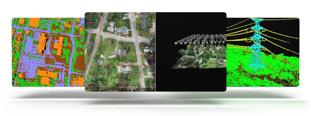
Improvements to point cloud data management in Version 26.1 include segmentation based classification for powerline identification and the extension of the Split Layers tool, which splits points clouds into layers based on attribute values such as classification, point source ID, or return number.

Advanced analysis of point clouds is improved with options in the Lidar QC tool to remove outlier control points after an initial comparison. Users will also notice improvements in Pixels to Points® drone/UAV-image analysis with color harmonization options.
For users looking to learn more about Global Mapper Pro’s photogrammetry processing tools, the Blue Marble Geographics Online Classroom has a new Pixels to Points course. These self-guided workflows cover the core features every user should know about, including ground control points, uploading drone imagery, generating point clouds and/or orthoimages, along with classifying ground points to create an elevation grid.
Product Manager, Jeff Hatzel, commented, “The new features in Global Mapper Pro stretch innovation further. This latest release includes exciting new updates to our AI-based tools. We have expanded our machine learning-based point cloud classification methods to include powerlines. Additionally, we have updated the Insight and Learning Engine’s deep learning image analysis tools with vehicle detection fine-tuning and custom model sharing.”


