


Blue Marble Geographics’ Global Mapper Pro version 25.1 includes exciting new tools and increased functionality.
Among other Pixels to Points updates, Ground Control Points can now be automatically identified and placed in imagery. Improvements have also been added to the award-winning Custom Classification Training tool. Subclassifications can now be created when classifying point clouds, adding detail to point cloud visualization without sacrificing functionality or processing.
The complete list of new features, updates, and bug fixes is included in the v25.1 Knowledge Base.
Pixels to Points Updates
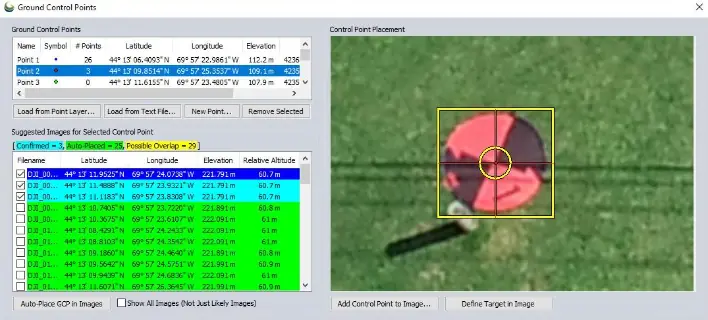
Automatic Ground Control Point Placement
Ground control points (GCP) in the Pixels to Points tool (P2P) are now managed in a separate dialog and have the additional functionality of automatically searching for ground targets. GCPs are optional GNSS-located point features that can be used to improve positional accuracy in photogrammetric processing. Each GCP has an x/y/z location that must be manually associated with an image pixel, an essential process that can be tedious at times. The new GCP Manager can locate and place markers on clearly identifiable targets in associated images, making the process of using ground control points much easier.
Setting up the GCP Manager is a straightforward process. If the feature in the image used to mark the GCP is a unique shape, use the Define Target in Image button to create a bounding box around the target. Global Mapper will use a method of shape detection to identify similar features in the other images. Other non-unique GCPs, such as the edge of a paint line, can still be manually placed in each image as normal. After assessment, Global Mapper will color code the images based on its confidence in point identification. For step-by-step instructions, check out the Knowledge Base.
Save a Pixels to Points Wizard Template
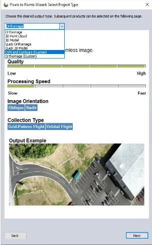
Along with the general quality and processing speed improvements, P2P v25.1 includes the ability to save Wizard settings to a template for use in future workflows. The Pixels to Points Input Wizard is designed to increase ease of use for existing users and make photogrammetric processing more approachable to new users with the streamlining of settings choices. Simply import your images and choose your most important output, including the option to run quick outputs for quality assessment. Global Mapper adjusts the Pixel to Points settings to match your input, providing an optional follow-up option to tweak the settings if desired.
New in version 25.1, these P2P Wizard settings can be saved as a reusable template. Once created, Templates will appear in the Project Type drop-down menu, as shown in the screenshot, with a “(Custom)” suffix.
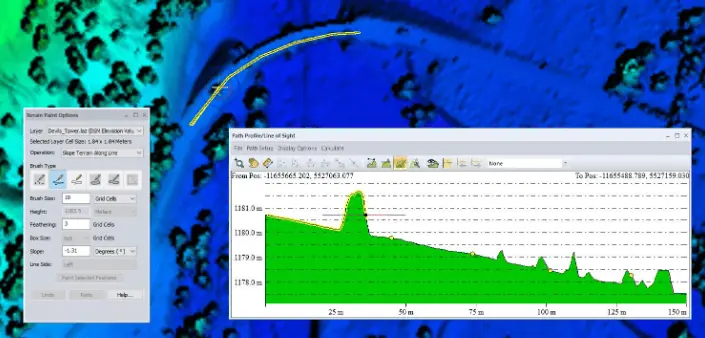
Terrain Painting within the Path Profile Window
Terrain Painting is a popular tool for editing elevation values in grid layers. This tool is often used to model future ground construction, remove imperfections in the data, fill holes, and much more. In v25.1, a new Terrain Painting function has been added to the Path Profile tool. The functionalities are still the same, but the Path Profile tool provides the ability to measure and visualize the terrain changes while working from an additional, perpendicular perspective.
The changes are still applied to the layer in the same way as the regular Terrain Paint tool, even in the areas that aren’t visible in the Path Profile window. Keep an eye on the 2D workspace to watch the cursor follow where you are in the Profile window. Learn more about the Terrain Painting tool in this blog: How to use the new Terrain Painting tool in Global Mapper Pro.
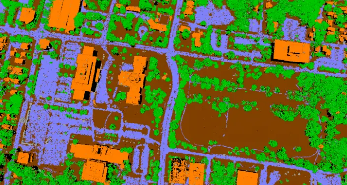
Create Subclassifications in Point Clouds
Subclassifications, a new custom classification feature in Global Mapper Pro v25.1, can be added to point cloud classifications to further refine the type of point feature with which it is being worked. Subclassifications are distinct in color and classification label without losing the functionality of the parent class.
For example, the automatic ground classification tools classify all points that make up the ground, including roads, sidewalks, etc.. By creating a custom subclassification called “roads”, you can add extra meaning to the “ground” point features without removing them from the existing class. This means that you can create a bare earth digital terrain model filtered to only include “ground” points without having to also specify that road classifications need to be included as well. Tools that measure Height Above Ground will automatically use road points as part of the ground measurement. Subclassifications are another advancement in the award-winning Custom Classification training tool to help users make the most out of their point cloud data.
Compare Point Clouds Against Gridded Elevation Layers
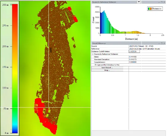
The Compare Point Clouds tool has been expanded to compare not only point clouds against point clouds, but also point clouds against one or more loaded gridded terrain layers.Gridded data is one of the most commonly provided types of elevation data online, especially for (relatively) historical data. Point cloud data, while commonly available now, hasn’t always been available for every study area. The ability to compare point clouds to a gridded elevation layer expands Global Mapper’s change detection abilities. In addition to the point cloud comparisons, gridded layers can still be compared against each other using the Compare Terrain tool.
To check out the exciting new functionality in Global Mapper standard and Pro v25.1, download a free 14-day trial today.


