


Discover how climate change is impacting Maine’s coastline as researchers use advanced GIS tools from Blue Marble Geographics to monitor erosion, analyze coastal health, and support resilience efforts at the vulnerable Camp Ellis Jetty. Find out more > >
Coastal communities are increasingly on the front lines of climate change, facing rising sea levels, severe storms, and accelerating erosion. A powerful example unfolded this past winter in Maine, where devastating storms battered the coastline and resulted in the loss of nearly 40 homes in the Saco Bay area. The Camp Ellis Jetty, a longstanding structure meant to protect the shore, has become a focal point of both vulnerability and resilience-building efforts.
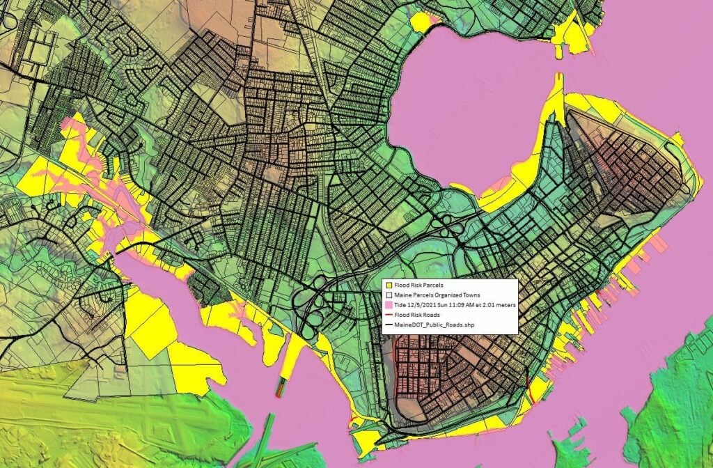
In an episode of GEOTalks, Dr. Will Kochtitzky, Assistant Professor in the GIS Program at the University of New England, shares his research into the impacts of sea-level rise on the Camp Ellis Jetty. Utilizing cutting-edge tools such as GIS technology, drone-collected lidar, and photogrammetry, Dr. Kochtitzky’s team is monitoring erosion patterns and salt marsh degradation to better understand how climate change is reshaping the coastline.
One unique challenge in Saco Bay is the reversal of coastal current flow—from south to north—causing intensified erosion at Camp Ellis. The U.S. government is currently working on a spur jetty project aimed at redirecting this flow and mitigating further damage. Kochtitzky and his team are closely observing how this structural change may affect ocean circulation and erosion trends in the future.
The episode also draws parallels to other regions like Florida and North Carolina, which were severely impacted by Hurricanes Helene and Milton. These shared experiences underscore the urgency of building coastal resilience through proactive planning and research.
By leveraging software like Global Mapper, Dr. Kochtitzky can process lidar data and simulate past and future flood events. This not only informs emergency response strategies but also provides vital insight into the health of Maine’s coastlines. Findings from recent storms revealed a dramatic 50% loss in dune systems and a troubling decline in salt marshes, which serve as critical buffers and biodiversity hubs.
Blue Marble Geographics will be at this year’s AUVSI’s XPONENTIAL 2025 – find them at Booth 2709.


