


GCPs are an important method for improving accuracy in photogrammetry. This process has been greatly improved in Global Mapper Pro v25.1.
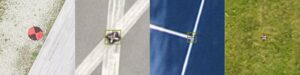
The benefit of including GCPs in processing is that it allows users to leverage the precision of high-accuracy GNSS units to imagery collected via drone/UAV. Traditionally this has been a painstakingly manual workflow, as each point feature must be associated with the pixel in which it appears throughout the image set. To streamline this, a new tool in Global Mapper Pro v25.1 automatically identifies and marks GCPs in images making this process faster and less time-consuming.
Pixels to Points, often referred to as P2P, is a photogrammetric processing tool within Global Mapper Pro that uses overlapping images to create photo-textured 3D models, orthoimages, and high-resolution point clouds. These generated data models can then be used in Global Mapper to measure terrain volume, assess structures, create detailed base maps, and more.
The Ground Control Points manager is the latest workflow improvement tool in Pixels to Points (P2P). This is a part of Blue Marble’s ongoing work to improve P2P output quality and processing speed with each version release.
The article also looks at:
- The new ground control points manager
- Automatic GCP identification and placement
To check out the new functionality in Global Mapper standard and Pro v25.1, download a free 14-day trial today.
Read the full article, or visit the Blue Marble Geographics website to find out more.


