Kongsberg Geospatial, the developer of IRIS Terminal, has joined forces with Drone Identification solutions provider Dronetag.
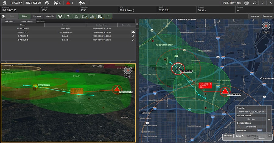
IRIS Terminal is a multi-domain situational awareness solution for unmanned aerial systems (UAS) and counter UAS operators. Now in its 2nd generation, IRIS Terminal has evolved from a defense-oriented system to an enterprise system for visualization of airspace traffic in beyond visual line of sight (BVLOS) UAS and C-UAS use cases.
The partnership between Dronetag and Kongsberg Geospatial will enable operators to quickly and easily visualize their aircraft, including cooperative UAS and surface assets, on IRIS Terminal’s common operating picture.
By joining forces with Dronetag, operators will be able to quickly and easily tag their aircraft using Dronetag Mini’s, and instantly visualize their position, altitude and speed on IRIS Terminal screens, regardless of the UAV model or manufacturer.
This integration also supports Network Remote ID as well as Broadcast Remote ID for large area airspace visualization, which goes beyond just Broadcast Remote ID and leverages public LTE networks.
IRIS Terminal’s multiple viewing configurations, coupled with its manufacturer-agnostic layering of additional sensors, allows DFR operators to view all of their (collaborative) Dronetag Mini enabled drones.
As well as this, DFR operators can target from any other additional sensors, such as ADSB or RADAR, for complete manned and unmanned airspace visualization. The system also allows for the fast identification of non-collaborative aircraft in their operational flight volume of responsibility.
Dronetag produces industry-leading Drone Identification solutions for UAVs, delivering superior battery life and efficient SWaP characteristics. The company’s products cater to retrofitting existing drones and integrating into new designs, ensuring compliant drone operations and advancing UTM capabilities.
Beyond broadcasting, the company provides solutions for receiving and visualizing Remote ID data. Reportedly recognized as the first to achieve the FAA’s Declaration of Compliance for Remote ID modules, Dronetag is endorsed by the EASA and participates in NATO’s DIANA accelerator program for innovative dual-use technologies.
Lukas Brchl, CEO of Dronetag, commented; “We at Dronetag firmly believe that Drone Identification is pivotal in advancing safety and control for pilots, emphasizing that it’s more than just regulatory compliance.
“Our collaboration with Kongsberg Geospatial in this transformative project highlights the significance of digitally visible drones, enabling rapid-deployment drone operations and pushing the industry towards innovation.
“Safety in drone operations is deeply embedded in Dronetag’s DNA, reflecting our shared vision with Kongsberg Geospatial and our dedicated five-year pursuit of our technology.”
Thomas Jimenez, Market Director for UAS at Kongsberg Geospatial, added; “This new integration into our increasingly versatile IRIS Terminal is very exciting as it leverages the Dronetag Mini to enable fast-deployment with complete layered airspace visibility.
“In the past it was difficult for an air-boss to coordinate across multiple agencies, each with their own manufacturer and model of UAS, when an emergency arose. Now an air-boss can tag, associate and launch UAV’s within minutes and have full airspace visibility within less than 30 minutes of arriving on-scene. This makes identifying friend from foe simpler than ever, as well as integrating with manned aircraft in the NAS.”
Kongsberg Defence & Aerospace AS will display its tactical solutions at Eurosatory 2024, Stand #G95, in Hall 6 and Ext Pe6b-B 62 outside.