


Kongsberg Geospatial is partnering with Echodyne to integrate radar technology into the IRIS Terminal, enhancing Beyond Visual Line of Sight (BVLOS) operations for unmanned aerial systems (UAS) in Advanced Air Mobility (AAM) applications.
The collaboration will provide enhanced situational awareness to unmanned aerial system operators by visualizing all airspace movement, cooperative and noncooperative, to ensure safe and reliable UAS operations.
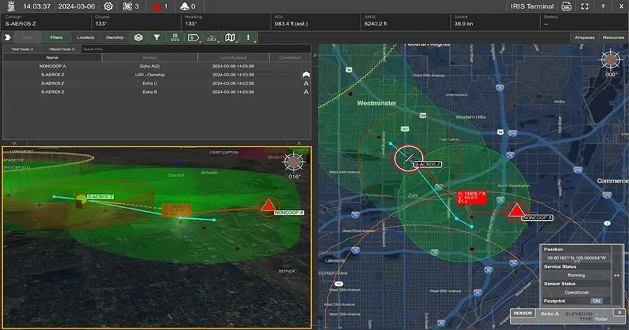
IRIS Terminal, now in its second generation, has been adapted from its defense origins to the enterprise UAS sector for visualizing airspace traffic, as well as controlling uncrewed systems in its GCS format. Ownship, cooperative, and non-cooperative traffic are all visualized inside IRIS Terminal’s multiple viewing configurations, along with useful features such as Detect-and-Avoid (DAA) sensor footprints, terrain awareness, or potential conflict warnings. Where the same aircraft produces multiple tracks (one track per sensor), IRIS Terminal’s ‘smart correlator’ feature correlates these multiple tracks into one single track to ensure the user interface (UI) remains uncluttered and the operator can focus on the work at hand.
Radar uniquely captures all airspace movement, regardless of weather or lighting conditions, and Echodyne’s patented metamaterials electronically scanned array (MESA®) radars create an exceptionally detailed picture of airspace movement. Proven in Defense and National Security markets, Echodyne’s patent-protected MESA radar extends electronically scanned array (ESA) performance to civilian security and airspace management applications at COTS (commercial off-the-shelf) price points for the first time. Adding Echodyne radars as pre-integrated components for IRIS enables Kongsberg’s customers to rapidly extend operations by combining extraordinary radar accuracy with market-leading visualization tools for managing enterprise-scale UAS operations.
“The benefits of combining market-leading data and spatial visualization capabilities with radar images showing such great detail of the airspace are enormous,” said Leo McCloskey, VP Marketing, Echodyne. “AAM applications requiring BVLOS approvals need to present the safety case for comprehensive airspace situational awareness and this collaboration delivers that for customers.”
“We couldn’t be more driven to forge this collaboration between two UAS industry leaders, and are excited about the BVLOS prospects to arise from this new relationship,” added Thomas Jimenez, Market Director for UAS at Kongsberg Geospatial. “Leveraging EchoGuard inside IRIS Terminal is truly the marriage of performance solutions to provide Electronic Observers with robust airspace deconfliction tools. Ground-based EchoGuard DAA is our starting point and we are very excited about the potential of EchoShield and more complex onboard solutions in the near future.”


