


Kongsberg Geospatial and SFL Scientific will demonstrate an Artificial Intelligence (AI)-driven system to allow autonomous Unmanned Aerial Vehicles (UAVs) equipped with sensors to detect and recognize a range of Chemical, Biological, Radiological, Nuclear, and Explosive (CBRNE) threats from the air.
The two companies will be showing video captured during live trials of the system in an online seminar hosted by the Association for Unmanned Vehicle Systems International (AUVSI).
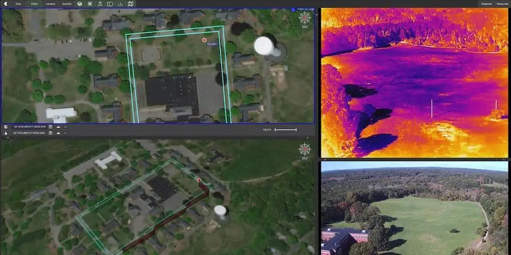
The presentation will feature an overview of how the system works, together with video clips of the system detecting chemical plumes in a series of recent controlled trials. The online seminar will be hosted on Wednesday, November 10th, 2021 at 3:00pm EDT by AUVSI. Register here>
The two companies will demonstrate how a medium-sized commercial drone carrying a sensor package can autonomously recognize chemical threats, identifying and ultimately displaying invisible hazardous plumes, in real-time.
This implementation fuses data from a visual, thermal, multichannel chemical sensor (the FLIR MUVE C360), with environmental and location data using a dedicated AI processor (the NVIDIA Jetson). The system leverages SFL custom bleeding-edge Generative Adversarial Networks (GANs) and Graph Deep Learning models to autonomously identify threats.
The system also includes sub-systems for route planning to access and address any threats the system detects.
The resulting sensor picture, including threat identification and route suggestions from the AI systems, will be displayed in an integrated picture within Kongsberg Geospatial’s IRIS UxS Ground Control Station (GCS) system. IRIS is an airspace situational awareness system developed to provide drone operators with the necessary situational awareness to safely operate one or more drones Beyond Visual Line-of-Sight (BVLOS).
The two companies hope to demonstrate how AI and machine learning systems can be evolved to allow drones to perform complex, mission-critical tasks in an increasingly autonomous manner.
“The rapid identification of chemical and visual threats is crucial in a variety of civilian and federal missions,” said Michael Segala, PHD, CEO of SFL Scientific. “Next-generation devices will be integrated with the capability to autonomously identify, locate, and help prioritize decisions in the detection of threats, anomalous activity, and other key indicators to support the safety and effectiveness of individuals working as first responders in potentially hazardous situations.”
Dr. Segala will describe how this pioneering work by SFL Scientific leverages next-gen AI technology to help interpret raw sensor data in real-time.
Rex Hayes, Director of Unmanned Systems for Kongsberg Geospatial will provide information on how the company’s IRIS system will be used to integrate the sensor data, and resulting AI interpretation of that data – including route planning – into a single, comprehensive picture to help reduce the cognitive load on UAS operators.
“IRIS helps UAS operators maintain a common operational picture of the air environment, while decreasing the cognitive load from interpreting separate and multiple sensor data. Leveraging AI to increase the autonomy of the system allows the operator to remain focused on their mission and be more effective overall,” said Mr. Hayes.


