


Kongsberg Geospatial and Pegasus Imagery Ltd have signed a Memorandum of Understanding (MoU) to work together to advance the development of safe, Unmanned Aerial Systems (UAS).
Pegasus will be implementing Kongsberg Geospatial’s IRIS UxS airspace situational awareness system as a navigational system for its BVLOS flight operations, and as part of its PV-02 Eos autonomous aircraft system.
Pegasus also conducts Beyond Visual Line-of-Sight (BVLOS) flight operations, providing photogrammetry, LiDAR and enhanced Full-Motion Video (FMV) surveys for government and industrial clients. Its flight missions range from infrastructure surveys of power transmission lines, to surveillance of forest fires.
“Kongsberg has a deep history delivering mission-ready solutions like IRIS UxS for enhanced airspace management in the most challenging environments”, said Cole Rosentreter, CEO of Pegasus Imagery. “Integrating these capabilities with our aircraft and onboard DAA systems will expand the safety and situational awareness essential for routine operations in integrated airspace.”
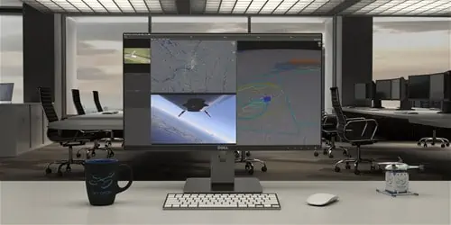
The Kongsberg Geospatial IRIS airspace visualization technology enables multiple drones and sensor feeds to be monitored simultaneously by a single remote operator and provides real-time calculation of aircraft separation and communications to enable BVLOS operations.
Built on Kongsberg Geospatial’s industry leading TerraLens SDK, IRIS provides advanced real-time 2D and 3D visualization of all airborne track and weather data, as well as cues, alerts and warnings to enable a single operator to monitor the complex airspace environment.
Kongsberg’s IRIS UxS has already been deployed in a wide range of applications for BVLOS flight operations, including drone delivery and oil and gas infrastructure surveys.
“We’re very pleased to be working with an industry innovator like Pegasus” said Ranald McGillis, President of Kongsberg Geospatial. “We’ve worked closely with them to integrate our technology with their PV-02 Eos platform.”
Pegasus designs, manufactures and operates autonomous UAS to deliver Intelligence, Surveillance and Reconnaissance (ISR) solutions at scale for industry and government. Equipped with proprietary Detect-and-Avoid sensor systems, Pegasus aircraft are able to safely operate in shared airspace with manned and unmanned aircraft to collect and deliver scalable, on-demand, data solutions.
Pegasus’ technology includes the Autonomous Airspace Awareness System (A3S) – a Detect and Avoid sensor system that uses airborne radar and other sensors to autonomously avoid potential hazards like birds, other drones and manned aircraft; a Moisture & Icing Detection Alert System (MIDAS) that provides early detection and pilot notification of icing conditions and buildup for manned aircraft; and the PV-02 Eos, its own autonomous aircraft.


