


The Federal Aviation Administration (FAA) recently updated Part 107 Waiver Safety Explanation Guidelines (WSEG) and Guiding Questions, including the important addition of Detect and Avoid (DAA).
In the following article, Kongsberg Geospatial details how its airspace visualization and deconfliction software, IRIS Terminal, speaks directly to several of the questions highlighted in section 107.31 when integrating DAA with CONOPS for waiver applications.
107.31 Visual Line of Sight Aircraft Operation
Section 2 b. 1) What type of DAA system is to be used? Radar/acoustic/visual?
IRIS Terminal is DAA hardware sensor agnostic. It integrates with today’s industry-leading unmanned aerial systems (UAS) sensors (e.g. Echodyne EchoGuard, IRIS Automation Casia G,Thales SQUIRE) and supports multiple industry standards, ensuring it will support the sensors of tomorrow (e.g. Asterix CAT021, 048, JSON, REST, MQTT). Moreover, IRIS Terminal visualizes outputs from multiple sensors simultaneously, overlaying them on the same screen and correlating duplicate tracks where multiple sensors detect the same aircraft.
Section 2 b. 4) If the DAA is ground-based, is there adequate low altitude DAA coverage to support the operation?
IRIS Terminal features our ‘sensor viewshed’ feature for heavily obstructed 3D terrain/environments. BVLOS operators can plan sensor placement ahead of time by visualizing the true line of sight viewshed of a sensor, ensuring that obstructions won’t affect coverage and supporting airspace deconfliction for the operation.
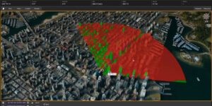

Section 2 b. 5) What is the maximum distance the system is effective in detecting other aircraft?
IRIS Terminal features our ‘sensor projection’ feature that lets operators visualize the (sensor manufacturer determined) 3D sensor field of view. Operators can overlay sensor performance information over the real-world operating area, taking into consideration range, azimuth and nadir projection field of view of the sensor.

Section 2 b. 7) What is the altitude above ground level the sUA will be flown during this operation?
Continuing the range visualization discussion from the previous point, the ‘sensor projection’ visualization ensures that the operator can visualize the sensor’s Field of View (FOV) within the operating area (including altitude). This ensures that the CONOPS-defined airspace to be deconflicted near the small unmanned aircraft (sUA) will remain within the sensor’s cone at all times.
Section 2 b. 10) Describe how the RPIC interfaces with the DAA system to monitor the airspace and manage the DAA operation?
The RPICs visualize their operating environment inside IRIS Terminal. The environment is presented in side-by-side 2D and 3D visualizations, with multiple mapping options, as well as real-time 2D/3D airport class airspaces, TFRs, NSURFs and other GeoPortal Advisories provided in real time by Aloft. RPICs can toggle on/off their sensor footprint for sensor awareness, and will visualize their ownship as well as all other traffic (cooperative and noncooperative) in real time.
Section 2 b. 14) How will ADS-B IN be integrated into the DAA system?
IRIS Terminal integrates with major ADSB-IN sensors (e.g. uAvionix Pingstation, Sunhillo Margate) as well as feeds (e.g. uAvionix Flightline, L3 HarrisNEXTGEN). These are clearly visualized both in 2D and 3D, and can be filtered based on AMSL and AGL altitudes for more relevance to UAS operators. When ADS-Btracks and DAA tracks for the same aircraft are detected, IRIS Terminal correlates both tracks to provide one single correlated track to keep visual clutter to a minimum.
Section 2 b.15) What is the alerting criteria for non-cooperative intruders and ADS-B-equipped intruders?
Alerts are raised based on the trajectory, speed and proximity of third-party aircraft(whether noncooperative or cooperative/ADS-B) who risk breaking the LOS boundary. The dimensions of the LOS ‘moving hockey puck’ are determined by the operator in their CONOPS and implemented in the IRIS Terminal configuration. The ‘moving hockey puck’ visual aid can be toggled on/off as required by the RPIC to provide added visual awareness inside IRIS Terminal.
Alerts can also be set based on operator-defined geofences. Operators can set ‘departure geofences’ which alert when their ownship departs a defined 3Dcorridor/volume as well as ‘intrusion geofences’ which alert the operator of any intrusion into the 3D volume in space of third-party aircraft.
Section 2 b. 16) Describe how the system visibly and audibly alerts the RPIC of operating area intruders?

IRIS Terminal features our ‘conflict warning’ system whereby the platform will alert the operator of any potential Loss Of Separation (LOS) risks. If one of our ownship is at risk of a possible loss of separation from a third-party aircraft(whether cooperative or non-cooperative) the operator will receive a loud audible alert, as well as a visual alert which must be acknowledged in order to mute the audible alert.
The conflict warning system also provides a bright vector line between the conflict aircraft and our ownship and provides real-time separation metrics: Horizontal separation, vertical separation and time (seconds) to predicted intrusion of ownship LOS boundary.
Section 2 b. 17) Is there visible and audible alerting for DAA system failures/degradation?
IRIS Terminal features an embedded resource status card which highlights all internal system services that are operational. The operator will get a visible and audible warning if any of the services degrade or stop.
For more detailed system health monitoring, IRIS Terminal integrates with the ResilienX Fraihmwork. Fraihmwork provides complex sensor health monitoring, offering complete system health cards that are visualized in the IRIS Terminal UI.


