
Showcase your capabilities
If you design, build or supply NTRIP Services, create a profile to showcase your capabilities and connect with visitors who have an active requirement for your solutions.




NTRIP services deliver real-time GNSS observations and correction data over IP networks to support precise positioning for drones, autonomous vehicles, robotic platforms, survey systems, and other unmanned equipment. Using NTRIP casters, clients, and compatible correction streams, these services can support DGNSS, RTK, Network RTK, PPP, and PPP-RTK positioning architectures.
This comprehensive guide covers NTRIP providers and services for applications including UAV mapping, direct georeferencing, precision navigation, infrastructure inspection, and field robotics.
Read the Technology Overview

Centimeter-Level Positioning and RTK Corrections for UAVs, Robotics and GNSS Systems

If you design, build or supply NTRIP Services, create a profile to showcase your capabilities and connect with visitors who have an active requirement for your solutions.

NTRIP services provide a practical way to deliver real-time Global Navigation Satellite System (GNSS) observations and correction data over Internet Protocol networks. NTRIP, or Networked Transport of RTCM via Internet Protocol, is commonly used to stream correction data from reference infrastructure to GNSS receivers operating on drones, autonomous vehicles, robotic platforms, survey systems, and other mobile equipment.
An NTRIP correction service can transport data supporting positioning techniques ranging from Differential GNSS (DGNSS) to Real-Time Kinematic (RTK), Network RTK, and certain Precise Point Positioning (PPP) architectures. By separating correction generation from the communications link, NTRIP allows compatible receivers to obtain GNSS data through cellular, Wi-Fi, satellite, or other IP connections rather than relying on a dedicated radio link.

Global GNSS RTK corrections for autonomous navigation & aerial surveying, from RTKdata
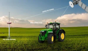
An NTRIP network normally combines correction-data sources, an NTRIP caster, and one or more clients. Understanding these components is important when integrating high-precision positioning into unmanned systems.
NTRIP is an HTTP-based application-level protocol designed for streaming GNSS data over IP networks. NTRIP Version 2 uses HTTP/1.1 conventions and remains compatible with Version 1 implementations. Typical NTRIP communications use TCP/IP to move continuous data streams between correction sources and connected users.
The NTRIP caster acts as the distribution point between incoming correction streams and connected clients. A caster may host many mountpoints simultaneously, allowing an NTRIP service provider to distribute data from different reference stations, correction networks, or correction products through one service endpoint. The caster normally distributes the supplied streams rather than generating the GNSS corrections itself.
An NTRIP server sends a GNSS data stream to the caster. The source may be an individual NTRIP base station, a permanent reference station, or processing infrastructure that generates network-based corrections from observations collected across multiple sites.
The NTRIP client connects to the caster, selects the required stream, and passes incoming data to the positioning engine. NTRIP software may run directly inside an NTRIP receiver, on an onboard computer, or on a separate communications gateway connected to the GNSS equipment.
Mountpoints identify individual data streams available through a caster. A source table, often referred to as a sourcetable, provides information about available streams and can help a client determine which mountpoint offers an appropriate correction format, reference location, navigation system, or other service characteristic.
Some network correction services need an approximate rover position before generating or selecting corrections. In these configurations, the NTRIP client can send an NMEA GGA message containing its current position to the caster, allowing the service to provide location-dependent data such as a Virtual Reference Station (VRS) solution or an appropriate network correction stream.
NTRIP is a transport mechanism rather than a single correction format. An NTRIP correction stream can therefore carry different GNSS message types according to the positioning method, receiver capability, and network design.
The appropriate NTRIP correction depends on both the correction provider and the algorithms and message types supported by the rover receiver.
Different correction products delivered through NTRIP allow GNSS infrastructure to support several positioning approaches.
The required technique should be selected according to coverage, initialization behavior, convergence time, accuracy requirements, receiver support, and operational environment.
NTRIP RTK service access can provide accurately referenced positions for Unmanned Aerial Vehicle (UAV) mapping, mobile surveying, and geospatial data collection. Accurate GNSS positioning can also support direct georeferencing workflows by improving the positional information associated with cameras, LiDAR systems, and other payloads.
Autonomous systems can use NTRIP corrections as an input to higher-accuracy navigation solutions. Applications include repeatable route following, waypoint navigation, automated docking, and other operations where stand-alone GNSS accuracy may be insufficient. Correction outages and degraded GNSS availability should be handled within the wider navigation architecture.
Drones, autonomous vehicles, and robotic equipment used around infrastructure or mine sites can use high-precision GNSS for inspection, mapping, machine positioning, and repeatable data collection. Network availability, satellite visibility, multipath, and interference remain important considerations in obstructed environments.
GNSS NTRIP services can support agricultural robots, unmanned aircraft, and field equipment that require repeatable positioning. Applications include crop surveying, field mapping, autonomous route guidance, and geographically consistent environmental measurements.
Unmanned Ground Vehicles (UGVs) and mobile robots can integrate NTRIP correction data with GNSS, inertial sensors, wheel odometry, or other navigation inputs. This allows precise satellite positioning to form one element of a broader localization architecture rather than acting as the sole navigation source.
Unmanned Surface Vehicles (USVs) can use NTRIP services for hydrographic surveying, bathymetric data collection, inspection, and autonomous surface navigation. Coastal NTRIP coverage and dependable communications are particularly important when continuous correction availability is required.
Compatibility between the service, correction stream, and rover equipment should be confirmed before deployment.
Receiver support should be assessed at message level, since basic NTRIP connectivity does not guarantee that every correction stream can be decoded or used by every positioning engine. NTRIP protocol compatibility should therefore be considered separately from RTCM and correction-format compatibility.
Choosing between NTRIP service providers requires more than comparing stated positioning accuracy. The complete correction, communications, reference-frame, and receiver architecture should be evaluated.
| Selection Factor | Technical Consideration |
| Geographic coverage | Confirm that the NTRIP network covers the entire operating area. |
| Reference station density | Consider baseline distances where performance relies on nearby physical stations. |
| Correction format | Match RTCM messages and correction architecture to the receiver. |
| Constellation support | Verify support for the GNSS constellations and frequencies used onboard. |
| Reference frame and datum | Confirm that the correction service and project coordinates use compatible reference frames and transformations. |
| Latency and update rate | Assess correction age, delivery latency, and update rate for the platform dynamics and positioning method. |
| Availability | Review service uptime, communications resilience, outage behavior, and backup infrastructure. |
| Roaming capability | Consider vehicles that move between service regions or communications networks. |
| Client capacity | Determine whether credentials and subscriptions support one receiver or a larger fleet. |
| Authentication and security | Assess credential management, access control, and whether HTTPS/TLS or another secure transport method is required and supported. |
| Cost model | Compare per-device, regional, fleet, and enterprise subscription structures. |
A suitable NTRIP provider should therefore be selected according to the complete operational profile rather than a single performance specification.
NTRIP continues to support evolving precise-positioning architectures as GNSS receivers, correction products, and connected autonomous systems develop.
These developments are making NTRIP a flexible transport layer for precise GNSS across connected unmanned and autonomous systems.


 Searching Companies & Products



