Discover environmental monitoring software developers and suppliers offering platforms for unmanned systems in agriculture, oceanography, meteorology, and disaster response. Solutions integrate advanced sensors and mapping tools for precise data analysis.
If you design, build or supply Environmental Monitoring Software, create a profile to showcase your capabilities and connect with visitors who have an active requirement for your solutions.
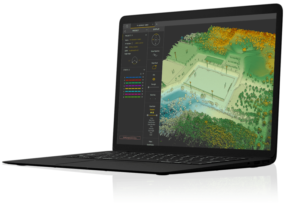
...he proprietary software developed by YellowScan to generate and visualize point-clouds. An... Our software provides you with auto-detection of strips, in-depth configuration and LAS files...
...of-the-art GIS software package that provides comprehensive geospatial data analysis and processing... The software is also designed for easy visualizing, editing, and analysis of LiDAR or point cloud...
Environmental monitoring software enables the capture and interpretation of data essential for understanding and managing natural environments. Deployed across air, land, and sea platforms, this software powers a vast array of environmental missions, enhancing the efficiency, accuracy, and responsiveness of monitoring programs.
Environmental Monitoring Software Solutions Across Sectors
Environmental monitoring is bringing a new level of data and information to many sectors. In agriculture, precision agriculture software leverages aerial data to track vegetation health, soil conditions, and crop performance, helping optimize yield while minimizing environmental impact. In meteorology, unmanned aerial systems (UAS) collect atmospheric data such as temperature, humidity, and particulate matter, feeding models for improved weather forecasting.
Delph Seismic Environmental Monitoring Software by Exail
Oceanography and marine environmental monitoring rely on AUVs and USVs, which utilize software to monitor parameters like salinity, turbidity, and underwater noise pollution. Hydrological missions benefit from software that integrates water quality sensors, supporting river, lake, and groundwater assessments. For disaster response, environmental monitoring software aids in rapidly assessing flood zones, landslides, or wildfire damage, guiding emergency interventions with live mapping and geospatial analytics.
An environmental monitoring platform typically supports seamless integration with environmental sensors, including those measuring greenhouse gases, radiation, and chemical hazards. Many systems incorporate GIS mapping software and terrain monitoring tools to visualize data spatially, allowing operators to detect trends and anomalies in real time.
YellowScan CloudStation Point Cloud Processing Software
Some solutions are built for specific monitoring goals, such as seismic profiling and air quality monitoring, ensuring high-fidelity insights even in complex or remote environments.
Advanced software platforms may include AI-powered analytics, machine learning algorithms for predictive modeling, and cloud-based data synchronization for team collaboration. Others provide open APIs to allow custom workflows or integration with broader environmental monitoring systems.
Key Types of Environmental Monitoring Software
There is a wide range of software tailored to different environmental contexts:
Water quality software: Monitors biological, physical, and chemical parameters in aquatic environments.
GIS-based environmental monitoring visualizes geospatial trends in land use, deforestation, urban development, and natural habitat encroachment.
Seismic software: Used with ground sensors and aerial systems to assess tectonic activity or structural vibrations.
Greenhouse gas and pollution tracking: Supports regulatory compliance and climate studies through accurate emissions monitoring.
Wildlife and biodiversity tracking software: Assists in conservation efforts by monitoring animal movement and population health.
Environmental monitoring software for unmanned systems is continually evolving. New platforms expand sensor compatibility, automate data workflows, and improve interoperability across fleets and domains.
Why Drones & Unmanned Systems Are Ideal for Environmental Monitoring
Traditional environmental monitoring can be time-consuming, costly, and limited by accessibility. Unmanned systems, however, offer scalable, rapid-deployment solutions capable of covering large or hazardous areas. UAVs can fly over agricultural fields, forests, and urban centers; USVs and AUVs can sample deep ocean waters or fragile marine ecosystems; and UGVs can operate in rugged terrains to gather soil or seismic data.
When paired with smart software, these platforms can automate complex monitoring routines, reducing the need for manual oversight and increasing data consistency. For precision agriculture, for example, drones equipped with multispectral cameras and AI-driven analysis platforms can deliver daily crop health updates. In air quality and radiation monitoring, real-time feedback from mobile units allows for immediate response to anomalies or dangerous levels.
The Role of Environmental Monitoring Platforms in Climate Research
As climate change and environmental degradation accelerate, the role of unmanned systems in scientific monitoring is growing. Software supporting biodiversity tracking, chemical hazard detection, and terrain monitoring plays a vital part in modeling long-term ecological changes and informing policy decisions. Integration with cloud platforms and open data systems further enhances the impact of these technologies by enabling collaborative analysis and public transparency.
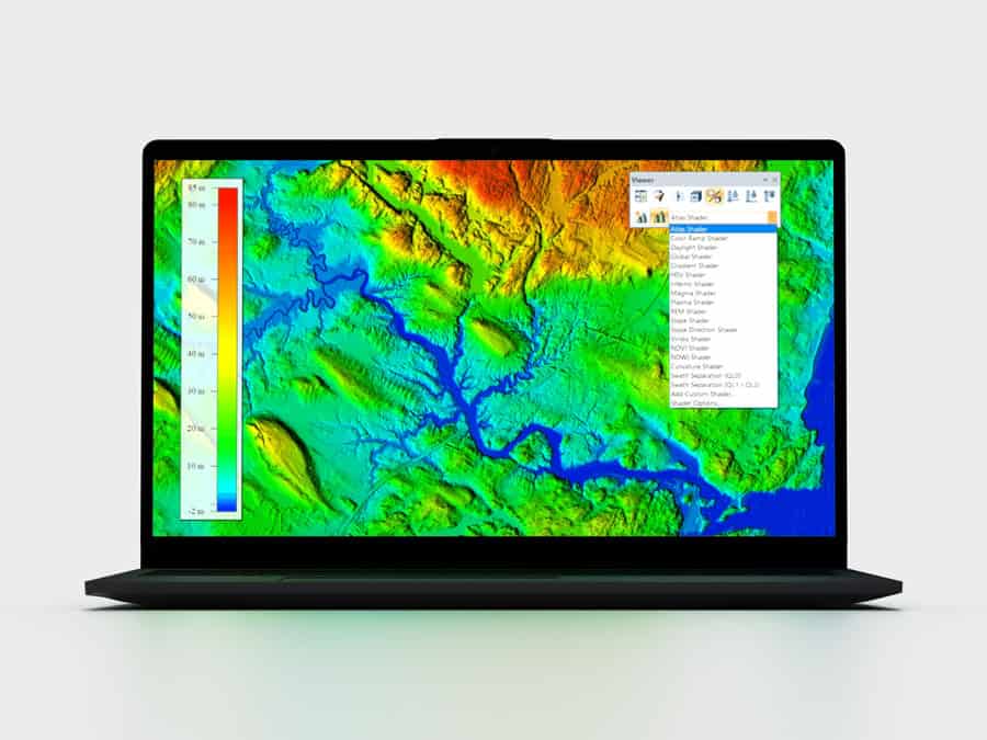
Global Mapper Pro Software by Blue Marble Geographics
Whether used by researchers, conservationists, emergency responders, or commercial agricultural operators, these platforms offer actionable intelligence to support a healthier and more sustainable interaction with the environment.
Environmental monitoring software built for drones and unmanned systems represents a significant leap in environmental intelligence. With capabilities ranging from real-time geospatial visualization to highly specific monitoring such as seismic profiling or greenhouse gas detection, these tools provide the foundation for accurate, efficient, and scalable environmental management. Their adaptability across sectors—from oceanography to agriculture—makes them indispensable for both research and operational use in increasingly complex environmental scenarios.
Blue Marble Geographics has launched Global Mapper 27, integrating the GeoCalc geodetic library as a standard feature alongside enhancements to LiDAR validation, automated terrain modeling, and expanded geospatial data format support
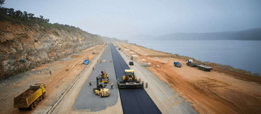
Blue Marble Geographics details how PT Waskita Karya (Persero) Tbk is using drone-based photogrammetry and watershed analysis within Global Mapper® to support environmentally responsible design and risk mitigation for a road project in Indonesia
Blue Marble Geographics’ Global Mapper provides a comprehensive set of visualization features that enhance the way users analyze, animate, and interpret geospatial information
Blue Marble Geographics’ Global Mapper software is used by Egis teams to process LiDAR and topographic data, create 3D terrain models, and perform hydrological analyses for environmental and hydraulic projects
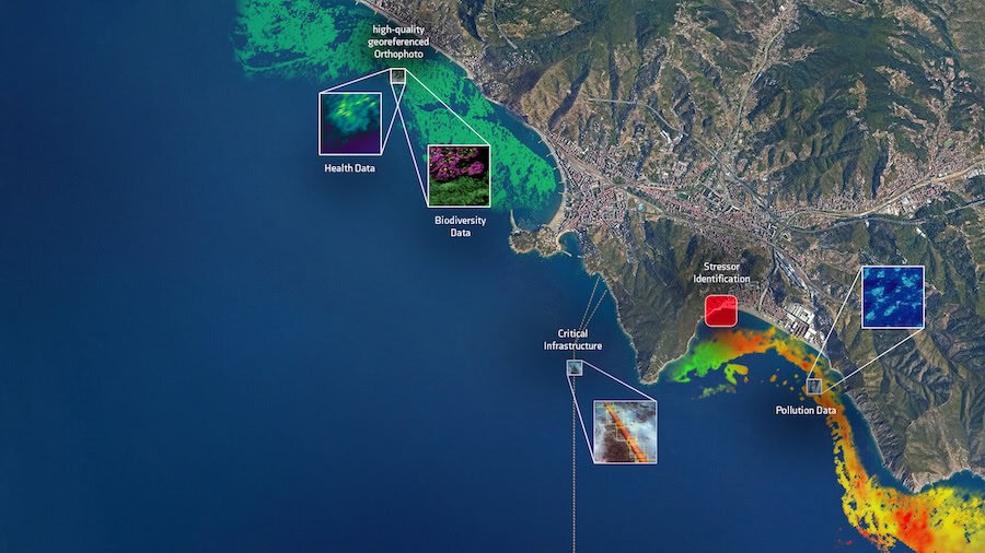
PlanBlue and Orpheus Ocean have partnered to advance seafloor intelligence, merging AI-powered imaging with deep-rated AUV platforms for sustainable ocean monitoring and protection
Blue Marble Geographics compares LiDAR and photogrammetric point clouds, outlining their collection methods, advantages, and integration within Global Mapper Pro®
YellowScan, with Australian distributor Sphere Drones, demonstrated the YellowScan Navigator in real-world coastal conditions, providing rapid, high-resolution mapping of artificial reefs with efficient deployment and safe, practical operation
Blue Marble Geographics’ Global Mapper® provides streamlined contour map generation from grids, point clouds, and LiDAR, with customizable intervals and advanced features for efficient, accurate terrain representation across industries
Sep 18, 2025
Advancing Unmanned Systems Through Strategic Collaboration
UST works with major OEMs to foster collaboration and increase engagement with SMEs, to accelerate innovation and drive unmanned systems capabilities forward.