


YellowScan, a leading developer of professional integrated UAV (unmanned aerial vehicle) LiDAR surveying solutions, has partnered with Unmanned Systems Technology (“UST”) to demonstrate their expertise in this field. The ‘Silver’ profile highlights how their lightweight survey-grade LiDAR technology can be used for a wide range of mapping and surveying applications, including civil engineering, forestry, environmental research, mining and archaeology.

The compact, lightweight LiDAR package provides sub-decimetre accuracy and extremely high data density for demanding mapping and surveying applications.
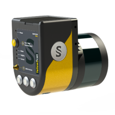 Surveyor Ultra provides the highest point density of any of YellowScan’s UAV LiDAR mapping solutions, incorporating a Velodyne VLP-32 LiDAR sensor and an Applanix APX-15 UAV GNSS-Inertial system for highly accurate position and orientation.
The system is ideal for high-speed VTOL drones and unmanned helicopters, providing rapid and fully autonomous data gathering with maximised range, and delivering sub-decimetre accuracy and high data density.
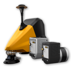
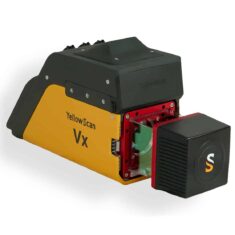 The YellowScan Vx-15 is a long-range, high-precision UAV LiDAR mapping solution, incorporating a Riegl Mini-VUX-1UAV LiDAR sensor and an Applanix APX-15 UAV GNSS-Inertial system for highly accurate point cloud production. Ideal for VTOL UAVs and unmanned helicopters, the fully integrated easy-to-use system provides rapid and fully autonomous data gathering with short processing times.
The compact, lightweight LiDAR package provides survey-grade precision and accuracy even with demanding mapping and surveying targets such as uneven landscapes and vegetation.
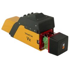 The Vx-20 is YellowScan’s most accurate UAV LiDAR mapping solution, incorporating a Riegl Mini-VUX-1UAV LiDAR sensor and an Applanix APX-20 UAV GNSS-Inertial system for highly accurate point cloud production. Featuring easy mounting onto VTOL UAVs and unmanned helicopters, the fully integrated, easy-to-use system can operate at altitudes of up to 100m while maintaining accuracy throughout the point cloud.

The compact, lightweight LiDAR package provides sharp, accurate detail for better vegetation penetration and is also optimized for measurement of snowy or icy terrain.
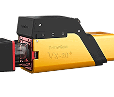 The YellowScan Vx-20+ is an upgraded version of the Vx-20, featuring the same best-in-class accuracy while upgrading to a Riegl Mini-VUX-2UAV LiDAR sensor for increased scanning frequency and double the point cloud density. The system can be easily mounted onto quadcopters, other multirotor drones and unmanned helicopters for fully autonomous mapping and surveying at heights of up to 85m.
The compact, lightweight LiDAR package provides long-range operation and superior detail for reliable results even on uneven landscapes and vegetation, and is also optimized for measurement of snowy or icy terrain.
 YellowScan Fly & Drive is a multi-platform geospatial LiDAR surveying solution allowing you to easily transfer your sensor from air to ground and vice versa in less than 5 minutes. Utilising either the Surveyor or Suryeyor Ultra lightweight integrated LiDAR systems, the Fly & Drive car pod can be conveniently mounted to any land vehicle. Sensors are compatible with a range of multicopter, fixed-wing and VTOL UAVs.
The versatile multi-scope solution combines high-resolution laser scanning and precise positioning for highly accurate geo-referenced point cloud measurement for a wide variety of applications.
To find out more about YellowScan and their LiDAR surveying solutions for UAVs, please visit their profile page:
https://www.unmannedsystemstechnology.com/company/yellowscan/


