


In the case study below YellowScan details a project undertaken by Hepta Airborne, using the YellowScan Mapper, to prove that drone-based powerline inspection could produce the same quality data as manned helicopter flights.
What is the Challenge?
Hepta Airborne, YellowScan’s Estonian based customer, won a contract with the Portuguese DSO (Distribution Service Operator) E-REDES, to launch a project with the objective of proving that drones can collect aerial inspection data just as well as manned helicopter missions. The plan was to compare data collected by drone to a helicopter-based dataset so they could benchmark the quality of the capture and output. With an electrical network of 229,168km, E-REDES wanted to expand their inspection capabilities and look into potential cost saving without a loss in quality for inspecting their powerlines.
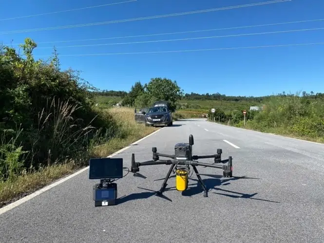
YellowScan Mapper mounted on a DJI M300 © Hepta Airborne
The measurements of the processed point cloud data had to match the quality (point density, accuracy, good reflections from the wires) of the best standard.
The stated objective of the flights was to produce data that would ensure safety in the power line corridor by detecting dangerous vegetation, illegal buildings and measuring wires.
Solution
Hepta needed to create a digital twin of the overhead lines and the corridor surrounding it. To achieve this objective, they needed to have a reliable and easy to use LiDAR sensor. As the project was time sensitive, there was a short time window to execute the flights, the hardware had to work like a charm and the data had to be reliable.
For Hepta that meant deploying the YellowScan Mapper. The Mapper is a purely aerial LiDAR solution that is ideally flown at 70m above ground level. It uses Livox’s Horizon laser scanner and is designed to fit most professional drones and comes with an integrated camera module. YellowScan Mapper is ideal for general topography projects and is particularly suited for archaeology, forestry and post-disaster missions.
The YellowScan Mapper seamlessly integrates with YellowScan’s portfolio of software solutions, CloudStation and LiveStation, making it easy to remotely check data while the system is flying, and comprehensively post-process, visualize and export survey data.
Mission Parameters
-
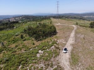
Aerial view of the area © Hepta Airborne
Survey size – 1000km of overhead lines
- Duration (planning, acquisition, processing)
- 1 month for planning,1 month for collection, 1 month for processing
- Number of flights – Hundreds
- Flight speed and altitude: 60 to 80m, 8m/s
- Used the Yellowscan Mapper to capture all point cloud data and flew: DJI Matrice 300 / DJI Zenmuse H20T

Speaking of the project Eduard Vainu, Head of Operations at Hepta Airborne said “Using YellowScan LiDAR solution Hepta was able to prove that drones are a scalable, reliable and cost-effective solution to collect aerial inspection data and can replace manned helicopters in the near future. Mapper’s low weight solutions ensures longer flight time, it’s easy to use and easy to train our pilots to operate Mapper. Processing speed is relatively fast, and the cost to quality ratio is very good when compared to other products. Integration with M300 drone is great, plug and play – no special actions needed.”

Results
For this mission the Hepta Team was able to average 150 points per square meter, with 5 to 10 cm accuracy, covering 1000 km of medium and high voltage line data in one month. The YellowScan Mapper and its drone flew 6 days a week in two shifts, for a total of 30 days without any errors. The area where the operations were conducted was extremely hilly, with elevation differences of hundreds of meters so the Hepta Team had to become quite resourceful and innovative in order to maintain a good connection with the drone between the hills.
The mission was a success and Hepta proved to E-REDES that drone-based powerline inspection could definitely produce the same quality data as manned helicopter flights. Based on this data, the grid maintenance personnel can plan the tree cutting in the overhead line corridor, but also detect potentially dangerous areas, where the lines are hanging lower than permitted. LiDAR data can provide an overview of potential illegal or dangerous structures in the power line protection zone. Based on the collected data, E-REDES was able to plan the steps to eliminate the potential danger.
In order to provide a meaningful Powerline inspection mission report to E-REDES, or any of their clients, Hepta takes collected LiDAR data from the YellowScan Mapper and process it into a georeferenced point cloud, vectorized, cut and measured according to the preset national standard for the locale. The analysis is compiled into a big excel report and a vector file containing the findings. The deliverables are then uploaded to uBird, Hepta’s priority Powerline and Utility inspection platform, for better visualization and asset management. By the conclusion of the project the E-REDES had 1000 km worth of information in uBird that consisted of:
- Georeferenced and analyzed RGB photos of the conditional situation
- Georeferenced IR and analyzed photos of the conditional situation
- Georeferenced and classified point clouds that are attached to their respective towers
- A shapefile describing the tower locations, vegetation measurements, span height measurements and found defects.
- All of the assets had their correct SAP numbers attached for better sorting
Key Benefits of YellowScan Mapper
- Best cost-performance ratio
- High point density and advanced accuracy and precision
- Low-weight
- Turn-key and simple to operate
- Self-powered
- Can be mounted quickly on any UAV, not only DJI’s
- Livox Horizon Laser Scanner
- Applanix APX-15 IMU
- High-performance GNSS antenna


