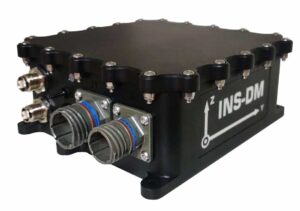
 Inertial Labs has released the INS-DM, a new dual-antenna GNSS-aided INS (inertial navigation system) that also integrates an AHRS (attitude & heading reference system) and optional air data computer. The high-performance strapdown system determines position, velocity and absolute orientation (heading, pitch and roll) for any device on which it is mounted, and is ideal for drones, UGVs (unmanned ground vehicles) and other autonomous and robotic vehicles.
The rugged IP68-rated system features excellent EMI shielding and is designed to MIL-STD-1275 standards. The INS-DM supports a range of Inertial Labs MEMS IMUs (inertial measurement units) as well as third-party units such as the Honeywell HG4930. It is also compatible with various multi-constellation GNSS receivers such as the Novatel OEM7 series or the u-blox F9 series.
The design of the INS-DM also includes an optional air data computer, supported by two Honeywell barometric sensors, and the ability to support an internal fluxgate or external stand-alone magnetic compass (SAMC). The INS-DM contains Inertial Labs’ new on-board sensor fusion filter, state-of-the-art navigation and guidance algorithms, and calibration software.
Other key features of the new INS-DM include:
- Commercially exportable
- GPS, GLONASS, GALILEO, BEIDOU, QZSS, RTK supported signals
- Total and static pressure sensors for calculating indicated airspeed
- SP, SBAS, DGPS, RTK and PPP corrections supported for precise real-time operation
- GNSS measurements and IMU raw data for post processing
- Advanced, extendable (based on application), embedded Kalman Filter based sensor fusion algorithms
- State-of-the-art algorithms for different dynamic motions of helicopters, UAVs, marine vessels, and ground vehicles
- Full temperature calibration of all sensing elements
- Aiding data: Wind sensor, air speed sensor, Doppler shift from locator (for long-term GPS-denial), external position and external heading


