
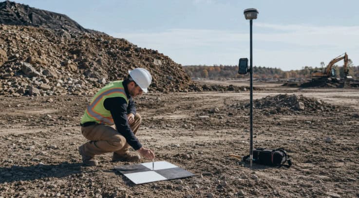
Traditional UAV mapping can involve substantial preparation before takeoff, with crews placing checkerboard targets and surveying them to centimeter accuracy. RTKdata examines how GCP-free mapping with real-time kinematic (RTK) positioning shifts this work from the field into the UAV positioning and processing pipeline, reducing ground preparation while retaining centimeter-level expectations for the final orthomosaic.
What RTK Replaces
Ground control points (GCPs) perform two functions: georeferencing a project and constraining the photogrammetry model to prevent reconstructed geometry from drifting or deforming.
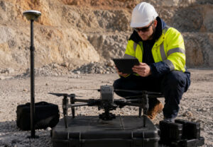
RTK directly addresses georeferencing. With a fixed integer solution, the receiver continuously estimates the antenna phase-center position at centimeter level. Associating these positions with individual images provides photogrammetry software with tightly georeferenced imagery.
Across repeated corridor, infrastructure, mining, and agricultural missions, this can reduce field labor substantially. Network RTK delivered through NTRIP also allows a UAV to obtain corrections from reference-station infrastructure without deploying a local base station for each mission.
Network density and reliability remain important. Shorter baselines and stable corrections help the receiver resolve and maintain a fixed solution during flight.
Positioning the Camera, Not Just the Antenna
RTK determines the antenna position, not the camera position. The antenna phase center sits above the airframe, while the camera focal point is lower on a fixed mount or gimbal. This lever arm is often 15 to 20 cm and can be greater.
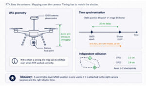
Unless this offset is measured and applied, each image can contain a systematic error despite correct operation of the RTK system.
Timing creates a related challenge. GNSS positioning corresponds to the GNSS epoch, while image positioning must correspond to the shutter event. A UAV traveling at 8 m/s covers 16 cm in 20 milliseconds, meaning a small synchronization discrepancy can create several centimeters of image-position error.
Hardware event markers, hot-shoe triggering, and reliable timestamping are therefore important. Integration between the receiver, flight controller, camera, and processing software matters alongside receiver accuracy.
Managing Vertical Accuracy
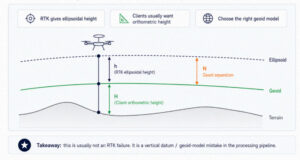
RTK provides ellipsoidal height relative to a reference ellipsoid, while clients commonly require orthometric height referenced to a geoid model or national vertical datum.
The difference can reach tens of meters and varies by location. In parts of Europe, geoid separation exceeds 45 m. Applying the wrong geoid model, or none at all, can produce substantial vertical error even when horizontal alignment is accurate.
The error may also appear as a tilt across the project rather than a uniform offset, making it difficult to identify without independent checkpoints.
Building Resilience with PPK
A fixed RTK solution can fall to float because of a long baseline, cellular coverage gaps, multipath near structures, or interruptions to the correction stream. Lower-quality positions can then enter the image block and influence the adjustment.
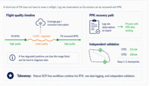
A resilient workflow treats the correction connection as a critical dependency. Dense reference-station coverage helps maintain shorter baselines, while receiver configuration can filter or reject poor-quality positions.
Raw observations should also be logged on board. If live RTK corrections deteriorate, the same flight can then be processed using post-processed kinematic (PPK) positioning.
RTK and PPK are complementary workflows. RTK provides live positioning, while PPK provides a recovery path when correction quality is interrupted, potentially turning a link problem into a processing task rather than a reflight.
GCP-Free Does Not Mean Control-Free
Strong RTK positions do not eliminate errors caused by weak flight geometry. Large nadir-only datasets can dome when camera calibration and block geometry trade errors against each other.
Accurate image positions reduce this risk but do not eliminate it. Instead of returning to extensive ground control, teams can use oblique imagery, cross-strips, or one or two independent checkpoints to verify rather than control the result.
Managing Datum and Epoch
Network corrections are tied to a particular geodetic frame and epoch, while deliverables may require a national datum, project datum, or older reference system.
In tectonically active regions, reference frames can diverge by several centimeters annually. A five-year-old project reference could therefore sit 10 cm from a correction stream expressed in the current frame. Without the correct transformation, centimeter-level antenna positioning can be lost during coordinate conversion.
GCP-free mapping consequently moves accuracy management rather than removing it. Lever-arm measurements, camera timing, geoid models, datum and epoch alignment, correction reliability, fallback processing, and independent validation all become part of the engineering workflow.
RTKdata provides NTRIP RTK correction access through more than 20,000 reference stations across more than 145 countries, supporting centimeter-level workflows for GNSS receivers, UAV mapping platforms, and robotics teams.