Advanced Navigation evaluates its Laser Velocity Sensor (LVS), a technology that utilizes infrared lasers to measure a vehicle’s ground-relative three-dimensional velocity with accuracy and precision in their article ‘Laser Velocity Sensor (LVS): A High-Accuracy Velocity Aid for GNSS-Denied Navigation’.
The article explains the core operating principle of the LVS, which is based on laser Doppler velocimetry. This method enables the sensor to measure velocity by detecting the frequency shift in infrared laser beams reflected from the ground or sea surface. The LVS is applicable across a range of environments and is suitable for use on both land and airborne platforms, provided there is a line-of-sight to the surface.
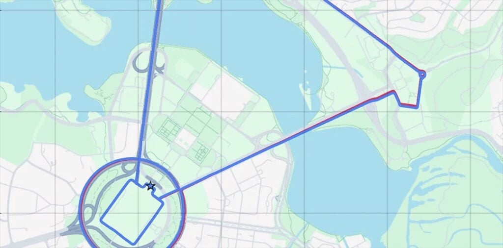
To evaluate the performance of the technology, a pre-production LVS unit was integrated with an Advanced Navigation Boreas D90 fiber-optic gyroscope (FOG) inertial navigation system (INS) to demonstrate navigation in GNSS-denied conditions. Advanced Navigation emphasizes the importance of aligning the LVS and INS reference frames to ensure accurate translation of velocity measurements.
Readers can expect an overview of the sensor’s development path, from initial prototypes to field testing. The article authored by Dr. David McManus, Patrick Wiltshire, Mark Gibson, and Dr. Lyle Roberts outlines the operating mechanics of the LVS, discusses how it integrates with navigation systems, and presents empirical results that highlight its effectiveness in maintaining navigation accuracy when GNSS signals are degraded or unavailable.