


The IRIS system was first developed as a prototype adapted from air defense technology, as a way of providing civilian drone operators with a safe way to conduct missions beyond visual line-of-sight (BVLOS). The first commercial version of the product appeared in 2017, with new features and capabilities being added over time.
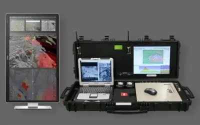
The Kongsberg Geospatial IRIS UxS Fleet Control Station technology enables multiple drones to be monitored and controlled simultaneously by a single operator and provides real-time calculation of aircraft separation, airspace monitoring alerts and communications line-of-sight prediction to enable detect and avoid for safe BVLOS operations. IRIS UxS integrates a variety of real-time data feeds including ADS-B, local radar and National Airspace Feeds to calculate “detect and avoid” warnings. IRIS UxS provides real-time 2D and 3D visualization of airborne track and weather data, as well as geo-fencing capabilities.
Find Suppliers and Manufacturers of Ground Control Stations
IRIS UxS has been adopted for fleet operations by drone delivery start-ups in the United States and Canada, and for BVLOS inspections of electrical transmission systems and oil and gas pipeline infrastructure. IRIS UxS is also used for monitoring airspace security and for emergency operations that integrate drones with other air traffic by a variety of police and security organizations.
IRIS UxS 2.0 is powered by the new high-performance Kongsberg Geospatial TerraLens 9.1 engine, providing very fast 3D map and terrain performance on large 4K displays. The system has been given an entirely new user interface, and a host of new features, including support for new sensors; an integrated live national airspace data feed; and integrated autopilots – allowing operators to control drones directly from the IRIS system.
The Kongsberg IRIS UxS Fleet Control and Airspace Management System was recently selected as an Xcellence Award finalist in the Detect-and-Avoid category by AUVSI.
“We’re very pleased to be acknowledged by a world-leading organization like AUVSI” said Ranald McGillis, President of Kongsberg Geospatial. “The Xponential show is an excellent venue for the demonstration of our technology.”


