


Amanda Lind at Blue Marble Geographics explains how to use the Compare Point Clouds tool in the company’s Global Mapper Pro tool for easy comparison of elevation between two point clouds.
Evaluating distance between point clouds is a great method for assessing edits that have been made to a file, photogrammetric accuracy, or detecting change in a landscape over time, or the accuracy of a lidar sensor type. The Compare Point Clouds tool in Global Mapper allows for the easy comparison of elevation between two point clouds. Version 24.1 of Global Mapper Pro includes the ability to generate Difference Histograms, and a new color by option for better visualization of the measured distances.
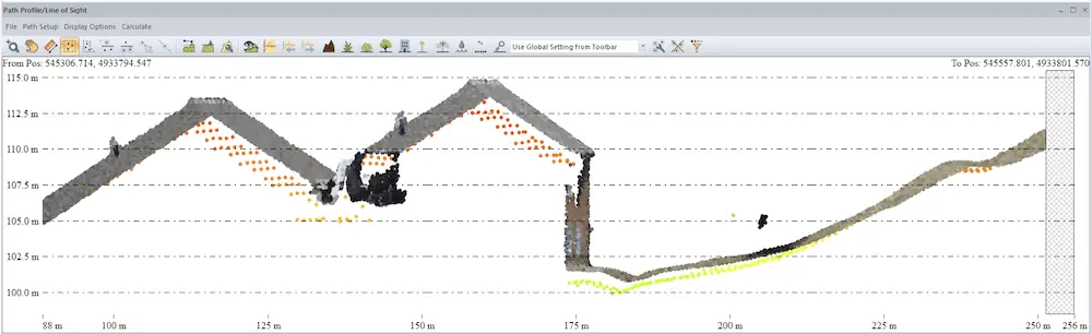
Using the Path Profile tool, we can see the slight difference in elevation between this P2P generated cloud (RGB) and the lidar (shaded by elevation). The Compare Point Clouds tool can quantify this distance.
Point Cloud Types
Point clouds are a common way to measure the ground surface and everything on it. In GIS there are 2 basic types of point clouds: lidar, and photogrammetric. Both types use the same tools in Global Mapper without distinction, but it’s beneficial for a user to know their limitations.
When comparing lidar to a photogrammetrically derived point cloud, it’s a good idea to filter by ground points first by turning off all other classifications with the Filter lidar tool.
One of the limitations of photogrammetry is the inability to penetrate dense forest canopies. If you compare the ground points from lidar to the lowest points captured with photogrammetry, there will often be a tree sized error. This error could be useful if you are measuring vegetation height (Thomas, 2020).
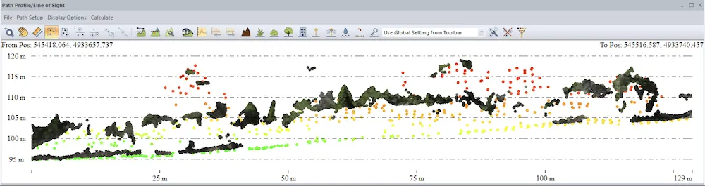
See in this Path Profile view of a forest how the darker points from the photogrammetrically derived point cloud don’t always capture the ground as the lidar does.
Compare Point Clouds tool
The Compare Point Clouds tool performs a 3D change detection between a set of point clouds to find points that have changed more than an allowed minimum difference. Functionally, it finds points in one point cloud that are farther than the set distance from another source/control point cloud.
Additional functionalities were added to this tool in version 24.1 as part of our Pixels to Points (P2P) workflow as an improved way for measuring accuracy of dense photogrammetric point clouds vs the typically more accurate lidar data. All of the settings are, of course, described in the knowledge base, but these two new optional settings are always worthy of further elaboration.
The difference report option will generate three windows. Two of these are distance histograms that display the count and distance of points in the Source (Compare Against) and the Reference (Find Changes In). Ideally the points will have a normal distribution of error represented by a bell shaped curve.
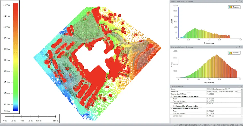
When the tool finishes, the points with a measured difference will be automatically selected (red) to give you the option to copy and paste them into a new layer.
The Save Distance to Closest Point in Generic Field option gives you the option to visualize the measured distance with point cloud color. After processing, change the Lidar Draw Mode to Generic to see these results. “Generic” is the term used to describe this extra attribute option that’s built into .LAS/.LAZ file types. Global Mapper takes advantage of this open ended attribute to allow users to export these calculated distance values as part of the lidar, if desired.
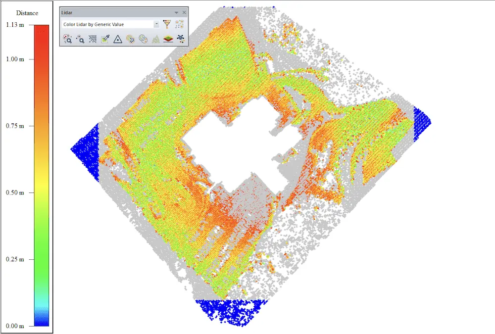
The ‘Color by Generic Value’ color is determined by the active shader. To change which colors are used, change the shader either in the drop down or in the configuration menu.
After assessing the difference between clouds, you can use the Fit Point Clouds tool to adjust one cloud’s position to fit the other.
A similar workflow is raster differencing, where the point clouds are converted into solid raster grids or Digital Elevation Models (DEMs), which when subtracted with the Combine/Compare Terrain Layers tool produce a difference raster or digital elevation difference layer to display the measured difference.
To measure the distance between point clouds and Ground Control Points (GCP), use the Lidar QC tool. After measuring the distance, Lidar QC provides the option to close the distance by shifting the point cloud(s) closer to the GCPs.
Try Global Mapper Pro with a free 14-day trial today.
Sources:
- Amanda F. Thomas, Amy E. Frazier, Adam J. Mathews & Carlos E. Cordova (2020) Impacts of Abrupt Terrain Changes and Grass Cover on Vertical Accuracy of UAS-SfM Derived Elevation Models, Papers in Applied Geography, 6:4, 336-351, DOI: 10.1080/23754931.2020.1782254


