6th Geospatial & Space Technology Forum 2027
The MENA Geospatial & Space Technology Forum 2027 (GIS MENA) will bring together senior government officials, geospatial leaders, space organizations, technology innovators, and industry decision-makers from across the MENA region for its sixth edition.
The two-day event will examine how geospatial intelligence and space technology are being used to understand, plan, and manage infrastructure, security, environmental monitoring, cities, and other complex environments.
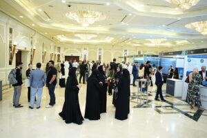
Image credit: Geospatial & Space Technology Forum (Great Minds Group)
For professionals working with drones, remote sensing, satellite data, mapping, and geospatial intelligence, the event will provide insight into the technologies and applications shaping location-based decision-making across the region.
When is the Event?
The MENA Geospatial & Space Technology Forum 2027 will take place on March 30–31, 2027 in Dubai, United Arab Emirates.
Themes
Geospatial Intelligence, GIS and AI
Sessions will examine real-time intelligence, spatial analytics, AI-powered mapping, and predictive decision-making.
Space Technology, Satellite Imagery and Earth Observation
The program will cover satellite data, remote sensing, and Earth observation applications supporting infrastructure, security, and environmental monitoring.
Digital Twins, Smart Cities and Connected Infrastructure
Discussions will consider the use of GIS, IoT, 3D modeling, and digital twins in the planning and management of cities and infrastructure.
Resilience, Security and Sustainability
The Forum will also explore the role of geospatial intelligence in defense, disaster response, climate resilience, transportation, utilities, and environmental management.
What’s On?
The two-day conference will feature keynote addresses, project showcases, expert panel discussions, and industry presentations, alongside a technology-led trade floor.
Content will span applications across government and defense, infrastructure and construction, smart cities, GIS, artificial intelligence, digital twins, satellite technology, remote sensing, drones, mapping, energy, utilities, transportation, logistics, telecommunications, environmental management, agriculture, mining, research, academia, and investment.
The Forum is expected to welcome more than 200 delegates and over 30 partners and exhibitors.
Speakers
The 2027 speaker program includes Mona Noureldin Husen, Deputy Head of Strategic Planning and Studies Unit at the Ministry of Municipality, Urban Planning Department; Dr. Abdelnasser Rashash Ali, Remote Sensing & GIS Consultant at the National Authority for Remote Sensing and Space Sciences (NARSS); Juan Tena Florez, Digital Services Director at KEO International Consultants; Mariam Shai, Regional Coordinator at CBL Holding; and Cem Cesur, Project Portfolio Manager at Albasateen Real Estate.
The event’s advisory board also includes Ahmed Almurshidi, General Director at Fujairah GIS Center; Saeed Al Mansoori, Director – Remote Sensing Department at Mohammed Bin Rashid Space Centre (MBRSC); Francesca Arici, Chief of Planning & Development Sector at Aseer Development Authority; and Ahmed Salih, GIS Associate Principal at ARDARA.
Who Will Attend?
The forum is intended for professionals working across geospatial intelligence, satellite technologies, infrastructure planning, transportation, environmental management, urban development, and digital transformation initiatives.
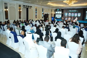
Image credit: Geospatial & Space Technology Forum (Great Minds Group)
Attendees are expected from industries including defense and security, energy and utilities, transportation and logistics, aerospace, telecommunications, disaster management, meteorology and climate change monitoring, and real estate development.
The audience includes general managers, directors, engineers, GIS specialists, analysts, researchers, consultants, developers, and project managers from fields including remote sensing, cartography, LiDAR, satellite mapping, and space policy and strategy.
Where is the Event?
Al Habtoor Grand Resort, Autograph Collection
Dubai
United Arab Emirates
To learn more about 6th Geospatial & Space Technology Forum 2027, to register to attend or exhibit, please click below .