New Marine Computer-Vision Navigation Sensor Released

Sea Machines Robotics’ AI-ris uses digital cameras and AI-processing to detect, track, classify and geolocate objects, vessel traffic and other potential obstacles to provide best-in-class situational awareness By Caroline Rees / 22 Jun 2022

Computer Vision

Discover cutting-edge solutions from 5 leading global suppliers
SUPPLIER SPOTLIGHT
Sea Machines AI-ris
Follow UST

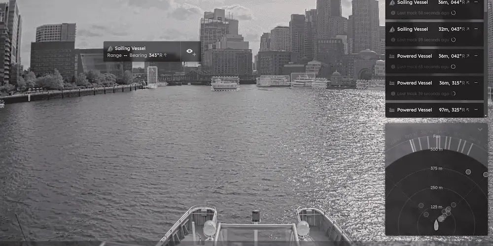
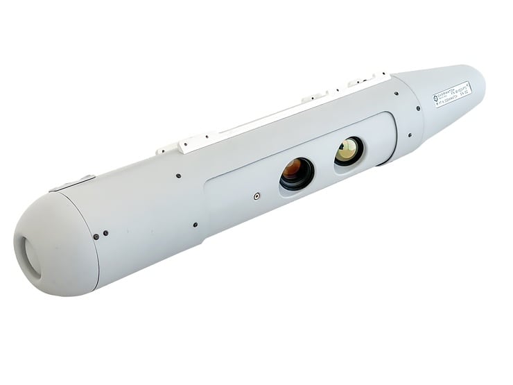
Sea Machines Robotics, Inc. has unveiledĀ AI-ris (Artificial Intelligence Recognition and Identification System), a new marine computer-vision navigation sensor designed to improve safety and performance of vessels at sea.Ā 

Revealed during Seawork2022, Sea Machines’ AI-ris uses digital cameras and AI-processing to detect, track, classify and geolocate objects, vessel traffic and other potential obstacles in the majority of operational conditions, day or night, to equip crew with best-in-class situational awareness. Computer vision helps improve safety for vessels and is also a critical technology for the advancement of autonomous command and control systems.

Sea Machines designed AI-ris to be ever-alert, with the ability to deliver predictable operational results that can improve vessel reliability as well as eliminate liabilities caused by human error, with the aim of radically improving vessel safety.

ā€œSea Machines is dedicated to building the future of ocean mobility. We envision a future with fewer accidents at sea. We are revolutionizing marine navigation with data-driven intelligence, autonomy and connectivity,ā€ said CEO Michael G. Johnson, Sea Machines. ā€œAI-ris enables a tremendous performance and safety increase. The superior capabilities of computer vision and AI will ensure a safer, more productive voyage.ā€

ā€œAI-ris is always scanning for obstacles and can alert the operator of potentially dangerous situations. It also labels objects very small in size, like swimmers, kayakers or animals, to those very large, like another ship,ā€ said CTO Trevor Vieweg, Sea Machines. ā€œWith the ability to detect, classify and geolocate such targets via optical sensors, AI-ris augments and surpasses the capabilities of existing marine sensor technologies, like radar and Automatic Identification System (AIS), enabling greater performance and achieving the highest levels of safety. In the future, this technology may also help responders detect marine oil spills.ā€

AI-ris is commercially available now and can be installed aboard existing vessels and ships, as well as new-builds. 

Posted by Caroline Rees Caroline co-founded Unmanned Systems Technology and has been at the forefront of the business ever since. With a Masters Degree in marketing Caroline has her finger on the pulse of all things unmanned and is committed to showcasing the very latest in unmanned technical innovation. Connect & Contact

Latest Articles

Most Read Articles on UST This Week

Here’s our round-up of the five most read articles on UnmannedSystemsTechnology.com this week

Jul 11, 2025
Vertiq Speed Firmware v0.1.1 Now Available with Bug Fixes

Vertiq has released firmware v0.1.1 to correct a parameter bug affecting telemetry and 3D mode settings on select G1 and G2 modules

Jul 11, 2025
The Role of ROVs in Unmanned Marine Operations

Oceanbotics has answered the most common questions about ROVs, covering how they work, where they're used, and key capabilities

Jul 11, 2025
LiveU File Transfer Speeds Up Drone Data Delivery for Critical Missions

LiveU’s File Transfer enables rapid transmission of large drone data files, reducing delays and supporting faster decision-making in public safety and infrastructure operations.

Jul 11, 2025
Exploring Differences Between M9PLUS & M9 GNSS Antennas

Discover the key upgrades in Maxtena’s new M9PLUS GNSS antenna, including improved performance, signal purity, and multipath mitigation over the original M9

Jul 11, 2025
USAF Uses Inertial Labs Drone Lidar for Tree Obstruction Survey

The US Air Force successfully used Inertial Labs drone Lidar and cloud software to quickly map tree obstructions at Joint Base Lewis-McChord (JBLM), improving airfield safety

Jul 11, 2025

Featured Content

USAF Uses Inertial Labs Drone Lidar for Tree Obstruction Survey

The US Air Force successfully used Inertial Labs drone Lidar and cloud software to quickly map tree obstructions at Joint Base Lewis-McChord (JBLM), improving airfield safety

Jul 11, 2025
New UAV to Combine Solar Hydrogen & Battery Power for Extended Flight

XSun and H3 Dynamics are developing the first UAV powered by solar, hydrogen, and batteries, aiming to deliver zero-emission, long-endurance unmanned flight

Jul 07, 2025
Enhancing Mangrove Restoration Through 3D Printed Drone Design

Explore how Inverto Earth, in collaboration with HP Additive, is using sustainable 3D printing and drone technology to drive large-scale mangrove restoration and protect vulnerable coastal ecosystems

Jul 03, 2025
Advancing Unmanned Systems Through Strategic Collaboration UST works with major OEMs to foster collaboration and increase engagement with SMEs, to accelerate innovation and drive unmanned systems capabilities forward.