


CHCNAV has released a case study explaining how its P330 Pro VTOL UAV, AlphaAir 450 LiDAR and i50 GNSS receiver mobile mapping solutions helped effectively collect data to measure the volume of an open pit mine site in Indonesia.
Effective and early surveying operations are crucial to the life cycle of mining projects.
In the first phase of the mineral exploration process, primarily for coal, the effectiveness of survey operations will impact all 5 typical stages of the mining life cycle (exploration, discovery, development, production, and reclamation). During this stage, mining companies hire geologists to determine the composition of the earth’s surface and study its geology to locate minerals. A mining geologist maps the locations of mineral deposits and uses aerial photographs, field maps, and geological studies to determine where and how much of a mineral is presented at the site.
Today, a wide range of digital instrumentation is available to help coal companies accelerate the exploration and development of mines while also gaining a competitive edge. Unmanned aircraft systems and LiDAR scanners with industrial grade GNSS and high precision IMU are technologies that address the challenges of providing accurate geographic data, visualization, and 3D models of the earth’s surface in a 3D digital format in minimum time.
- How did the P330 Pro VTOL UAV and the AlphaAir 450 LiDAR help with the effective data collection to measure the volume of an open pit mine site in Indonesia?

Figure 1. The set of CHCNAV’s solutions used during the mineral exploration project in Indonesia.
- The P330 Pro UAV allows small- and large-scale aerial surveys to be done with extreme data quality, cost, and time savings. It comes with a portable ground control station (GCS) for remote control and communication between the drone and the operator. Manual and automatic navigation modes are available. Vertical take-off and landing capabilities make it a particularly convenient drone to operate and transport.
- The AlphaAir 450, a lightweight and rugged system that integrates a high-performance LiDAR with an industrial-grade professional 26 MP camera and a high-precision inertial navigation system for quality data collection.
- In addition to the UAV and LiDAR, the i50 GNSS receiver and the pre/post-processing software provided with the AA450 were deployed. Global Mapper, a 3rd party software, was used to obtain the final calculation of the area measured in this project.
What are the main benefits of the solution used in the project?
1. High efficiency and accuracy: cover more than 5 km² per mission with an error of less than 5 cm.
2. LiDAR accuracy in vegetated areas: enable survey of the actual ground surface, including structures that might be missed by other survey methods due to dense vegetation.
3. Easy to use: one-button operation and automatic flight.
4. Field crew safety: no need to transport the instrument to survey the entire area.
5. Fast results: the measurement of the large surface area can be done in one day.
What precautions should be taken before surveying a site with a drone?
When surveying a new area for mine development, it is necessary to pay attention to the following aspects:
1. Traffic: understanding the traffic situation in the area, roads, railroads, airports, etc., is needed to schedule equipment logistics during field operations properly.
2. Population: research the urban and rural communities living in the area, including their culture, customs, and language habits, to prevent any difficulties during the operation.
3. Geographical conditions: when the survey is conducted in mountainous areas with complex terrain types and features, knowledge of the terrain is essential to the mission.
4. Meteorological conditions: key parameters are wind, rain, fog, temperature, and air pressure. Historical statistics can indicate the number of operational months and days in the region of measurement, providing a basis for planning flight operations.
What are the main steps involved in setting up a UAV mapping survey?
Preparation is mainly related to setting up control points, designing the drone’s flight path in the software, and setting up a GNSS base station.
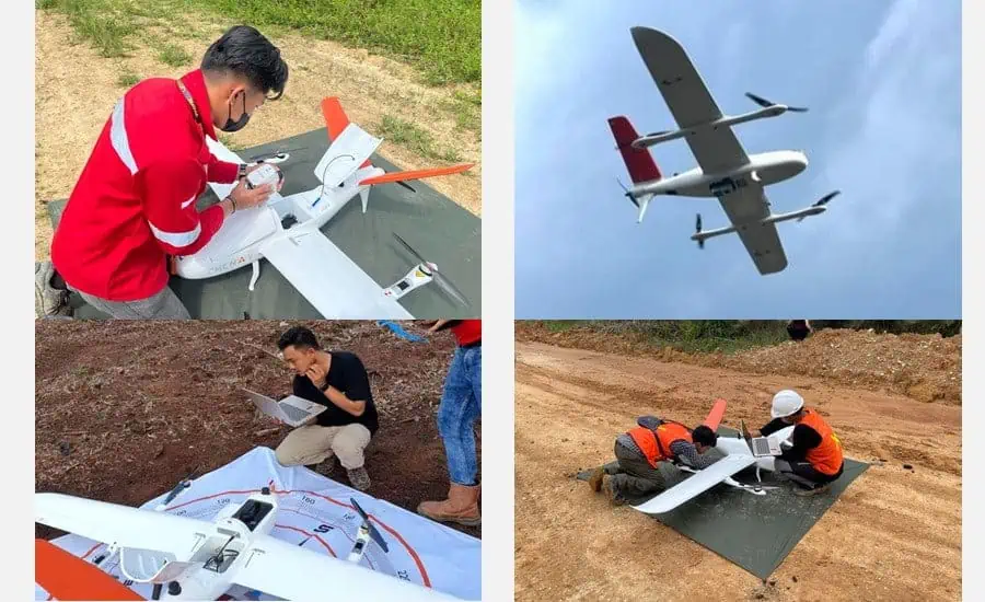
Figure 2. The survey team in Indonesia prepares the P330 Pro and AA450 LiDAR for the airborne survey.
The survey route can be planned in advance in the office or directly in the field. When designing the route, the key parameters can be determined according to the requirements, and then the flight parameters are set in the software. For example, when designing the UAV trajectory, the speed is usually less than 18 m/s, the length of the trajectory is more than 1,000 m, and the relative height can be over 200 m.

Figure 3. The survey route planning for the P330 Pro UAV.
A GNSS base station must be installed before the data acquisition process to ensure accurate positioning. If there is an RTK correction source within the flight area, such as a local GNSS RTK network, it can be used to eliminate the need to install a local ground base station. When high accuracy is expected, it is recommended to limit the radius between the UAV and the base station to a maximum of 5 km.

Figure 4: A high-precision i50 GNSS receiver is installed in the field.
When everything is ready, and before each operational survey, a flight test of the UAV without payload is performed to confirm the performance of the flight.
How to process the raw point cloud data collected by a LiDAR scanner?
After the completion of the survey, the LiDAR system should remain stationary for 3 minutes. Afterward, the raw data can be downloaded and processed. Typically, a LiDAR system can obtain the following data in a single flight:
1. GNSS reference station data, the GNSS data obtained by the base station.
2. POS data, mainly includes GNSS data and IMU data from AA450.
3. Laser scanning data.
4. Images taken by the camera.
The POS data is processed in the POS module of the CoPre, a powerful and highly configurable software package that can process all available GNSS and IMU data, providing high-accuracy combined navigation information, including position, velocity, and altitude. The next step involves the generation of point clouds by merging the raw laser data and photos with the POS data and then creating a LAS file based on the WGS84 coordinate system.
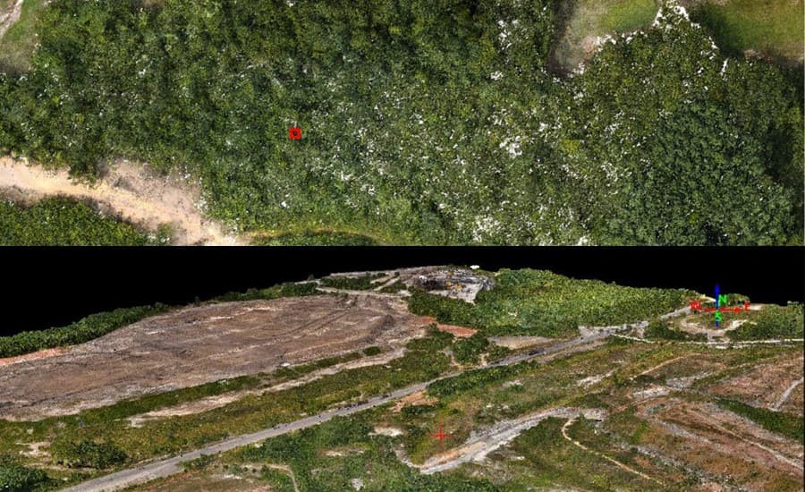

Figures 5 and 6: Point cloud segments collected by P330 Pro and AA450 at the site and processed in the CoPre software.
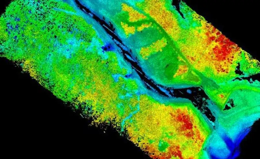
How to compute a cubature and determine site characteristics from an airborne LiDAR survey?
For the volume calculation, Global Mapper (a third-party software) was used. The calculation process was based entirely on the imported point cloud data collected by the P330 Pro and AA450 and processed in the CHCNAV software. The site characteristics were determined, and the final data were obtained by generating a mesh model and using the volume calculation interface.

Figure 7. Mining site volume calculation.
In this project, airborne survey solutions were used to obtain the actual information about the entire area. The surface was mapped, and the total volume of the area was calculated. However, CHCNAV’s mobile mapping solutions go far beyond this, as our LiDAR tools can effectively detect hidden surface geology and monitor ground subsidence.
From exploration to exploitation of mineral resources, the acquisition of highly accurate topographic information is critical to the safety and success of any project; it will ultimately impact its overall operational efficiency.


