CHC Navigation (CHCNAV) has introduced the AU20 MMS, an advanced vehicle-mounted mobile mapping system built to deliver precise and efficient collection of 3D spatial data for a wide range of professional applications.
By combining high-performance LiDAR technology, versatile sensor support, and intelligent data processing, the AU20 MMS offers a practical and flexible solution for professionals working in road surveying, asset management, and infrastructure documentation.
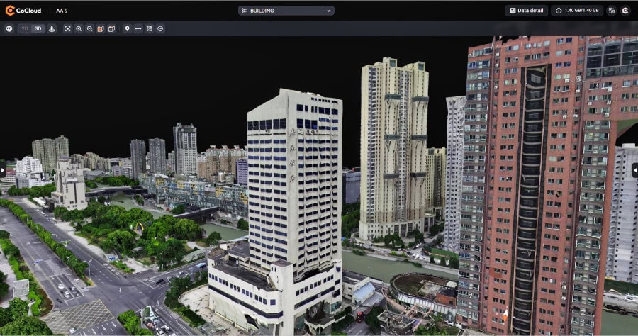
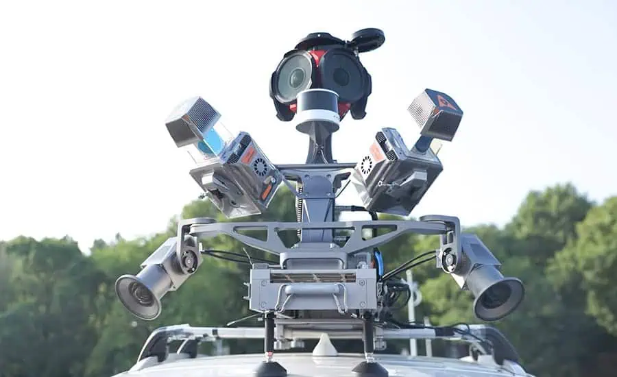
The AU20 MMS features a LiDAR system that incorporates fourth-generation real-time waveform processing (RWP) technology. This enables the system to achieve a scan rate of 2 million points per second and 200 revolutions per second, producing point cloud data with 5 mm accuracy and 3 mm precision. Such detailed capture capabilities allow for the identification of fine surface characteristics and features for comprehensive asset inventories and condition assessments. The system’s long-range, multi-cycle laser technology facilitates high-density data capture up to 250 meters in vehicle-mounted applications.

Constructed on the adaptable AP7 vehicle platform, the AU20 MMS can support a dual laser scanner setup, which significantly increases data density. The platform’s design incorporates a 45° scanning angle to reduce data shadows and improve the detection of vertical structures and road signage. Furthermore, the AP7’s built-in processor accommodates the integration of up to eight external sensors, including specialized pavement detection cameras and panoramic cameras such as the Ladybug5+ and Ladybug6, offering users flexibility in data acquisition strategies.
The AU20 MMS leverages AI-based algorithms to refine data quality and streamline processing. AI-driven computation adjusts the Vehicle Motion Trajectory (VMA), automatically identifying control points to correct point cloud inaccuracies within two centimeters. This ensures the data meets highway-grade survey standards, even in complex scenarios.
Additionally, AI-powered panoramic coloring achieves over 95% accuracy in recognizing and handling vehicles and pedestrians, resulting in clean, interference-minimized colorized point clouds through efficient one-click optimization.
CHCNAV’s proprietary software suite, CoPre and CoProcess, streamlines workflows by integrating intelligent automation. CoPre optimizes data preprocessing, enabling real-time adjustments to point clouds and imagery while minimizing manual intervention. CoProcess leverages AI algorithms for feature extraction, including road assets, terrain models, and building structures, accelerating project delivery.