Visual Inertial Navigation Systems (VINS) combine camera-based perception with inertial sensing to provide accurate positioning, orientation, and motion estimation for autonomous platforms operating in GNSS-denied environments. Leveraging Visual Inertial Odometry (VIO) and Visual-Inertial Simultaneous Localization and Mapping (VI-SLAM), these systems fuse camera and IMU data to estimate vehicle state, track movement, and build environmental awareness in real time.
This page showcases leading VINS manufacturers built for deployment across UAVs, UGVs, AUVs, and robotic platforms for mapping, inspection, ISR, and autonomous mobility.
If you design, build or supply Visual Inertial Navigation Systems (VINS), create a profile to showcase your capabilities and connect with visitors who have an active requirement for your solutions.
Visual Inertial Navigation Systems (VINS): Autonomous Navigation & Positioning in GNSS-Denied Environments
Overview by
William Mackenzie
Updated:
Introduction to Visual Inertial Navigation Systems (VINS)
Visual Inertial Navigation Systems (VINS) combine camera-based perception with inertial sensing to provide accurate positioning, orientation, and motion estimation for autonomous platforms. By fusing data from one or more optical cameras with measurements from an Inertial Measurement Unit (IMU), VINS enables unmanned vehicles to calculate their real-time kinematic state without relying on external positioning signals. This capability has become essential across the unmanned systems sector as operators look to safeguard land, air, and sea platforms against the vulnerabilities of traditional satellite-based positioning.
While the Global Navigation Satellite System (GNSS) remains a valuable asset for global coordinates, its vulnerability to signal attenuation, multi-path reflection in urban canyons, and intentional electronic jamming or spoofing presents a critical vulnerability. VINS resolves this by acting as a high-frequency, self-contained dead-reckoning engine that maintains strict operational readiness in contested or physically obscured environments. Today, the technology is widely integrated into tactical Unmanned Aerial Vehicles (UAVs), rugged Unmanned Ground Vehicles (UGVs), subsea Autonomous Underwater Vehicles (AUVs), and localized industrial robotics to support long-range mapping, facility inspection, and tactical military operations.
Vision Navigator visual-inertial navigation system by Xsens
Key Operating Principles of Visual Inertial Navigation
To design an effective autonomous localization framework, developers must understand the core capabilities, sensor interactions, and software methodologies that define modern visual inertial navigation. These elements work together to transform raw environmental data into actionable position states.
Visual Sensing Technologies
The visual element of a VINS solution can take several forms depending on the platform and mission requirements. Monocular camera systems remain popular for smaller unmanned platforms due to their low size, weight, and power requirements, while stereo vision systems provide direct depth perception that can improve obstacle detection and localization accuracy.
More advanced architectures may incorporate multiple cameras to increase field of view, improve redundancy, and maintain feature visibility during complex maneuvers. Event-based cameras are also attracting growing interest within the autonomy sector. Rather than capturing conventional image frames, these sensors detect changes in brightness, enabling high-speed navigation with lower latency and reduced motion blur.
Sensor Fusion
The core strength of VINS lies in its ability to combine the complementary strengths of visual and inertial sensors. Cameras provide rich environmental information but can struggle in low-light conditions or feature-poor environments. IMUs deliver continuous motion measurements regardless of visibility but accumulate error over time.
By synchronizing and fusing these data streams, VINS creates a stable estimate of position, velocity, and attitude. Modern systems rely on sophisticated sensor fusion architectures capable of processing large volumes of data in real time while maintaining the low latency required for autonomous navigation.
Visual Inertial Odometry (VIO) and SLAM
When deploying a visual navigation system, engineers generally choose between localized odometry and global mapping techniques depending on payload constraints and mission parameters:
Visual Inertial Odometry (VIO): Computes the platform’s current state relative only to a local, sliding window of recent history. This approach is highly efficient and ideal for immediate flight control or vehicle guidance, though it accumulates a small amount of drift over long trajectories.
Visual-Inertial Simultaneous Localization and Mapping (VI-SLAM): Incorporates inertial measurements alongside camera-derived features to build a map of the environment while tracking the platform’s position within it, using loop closure to eliminate accumulated drift.
These capabilities are particularly valuable for autonomous systems operating in unknown or changing environments where pre-existing maps may not be available.
VINS Architecture & System Components
Implementing a reliable visual inertial architecture demands a careful selection of physical hardware and software layers that can handle demanding environmental factors. Each component must balance computational throughput against strict size, weight, power, and cost constraints.
Camera Technologies for VINS
Camera selection has a significant impact on navigation performance. Global shutter cameras are often preferred because they capture an entire image simultaneously, eliminating distortion caused by rapid motion. Rolling shutter cameras can offer lower cost and power consumption but may introduce image artifacts that affect feature tracking.
Visible-spectrum cameras remain the most common option, although low-light sensors and HDR imaging technologies are increasingly used to improve performance in challenging lighting conditions. Thermal cameras are also being integrated into advanced navigation systems, enabling operation in darkness, smoke, fog, and other visually degraded environments.
Inertial Measurement Units
The Inertial Measurement Unit (IMU) serves as the motion-sensing component of a VINS architecture, measuring acceleration and rotational movement across multiple axes. Micro-Electro-Mechanical Systems (MEMS) based IMUs dominate the commercial unmanned systems market due to their compact size and affordability, while tactical-grade and navigation-grade sensors provide greater stability and reduced drift for higher-end applications.
When evaluating IMUs for a visual inertial system, key technical considerations typically include:
Bias Stability: The stability of the sensor’s output over time, with high-performance tactical-grade options requiring ratings below 1°/hr to bridge prolonged visual dropouts.
Noise Performance: Angular random walk and velocity random walk metrics that define the baseline precision of the raw data.
Update Rate: High-frequency output capacity, typically between 100 Hz and 1 kHz, necessary to track rapid platform maneuvers between camera frames.
These factors directly influence the quality of the navigation solution and the system’s ability to maintain accurate positioning during extended GNSS-denied operations.
Processing Hardware
Visual-inertial navigation is computationally intensive, requiring significant processing resources to analyze imagery, perform sensor fusion, and execute navigation algorithms in real time.
Modern VINS solutions utilize diverse processing architectures depending on platform constraints:
GPUs and AI Accelerators: Deployed to accelerate visual feature extraction, neural network processing, and dense matching algorithms.
FPGAs: Utilized for low-latency, deterministic preprocessing of high-rate camera and IMU data streams.
Embedded Computing Platforms: Selected for smaller UAVs to prioritize low power consumption and compact form factors while preserving baseline localization capabilities.
Software Frameworks and Middleware
The software environment plays a critical role in determining system flexibility, scalability, and ease of integration. ROS and ROS 2 have become widely adopted throughout the robotics and autonomous systems industries, providing a common framework for sensor integration and software development.
Many VINS implementations also utilize DDS-based communication architectures and real-time operating systems to support deterministic performance. Depending on the application, operators may choose between open-source frameworks that offer flexibility and proprietary solutions optimized for specific mission requirements.
VINS Algorithms & Navigation Methods
The processing algorithms running within an onboard computer dictate how effectively the platform converts sensory data inputs into an accurate trajectory estimate. Different math models provide unique trade-offs regarding tracking style, filtering speed, and error drift management.
Feature-Based Visual Inertial Odometry
Feature-based visual inertial odometry remains one of the most widely deployed approaches to VINS. These systems identify and track distinctive visual landmarks across successive images, combining this information with inertial measurements to estimate movement through the environment. Advanced implementations employ techniques such as landmark management and bundle adjustment to refine estimates and reduce accumulated error, improving navigation accuracy over longer mission durations.
Direct Visual Odometry Approaches
Rather than tracking discrete visual features, direct visual odometry methods utilize image intensity information across larger portions of the scene. This approach can provide greater robustness in environments where traditional feature extraction may be challenging and allows more of the available visual information to contribute to navigation performance.
State Estimation Techniques
Accurate state estimation is fundamental to any VINS architecture. Modern systems employ a variety of approaches, including Extended Kalman Filters (EKF), Unscented Kalman Filters (UKF), factor graph optimization, and sliding-window estimation techniques.
The choice of estimation method often depends on the desired balance between computational efficiency, navigation accuracy, and platform constraints. Multi-State Constraint Kalman Filters (MSCKF) propagate the vehicle state using high-rate IMU data and update it when visual features are tracked across multiple camera views, keeping computational overhead predictable. For complex paths, optimization-based factor graphs perform a localized non-linear bundle adjustment over a sliding window of recent states to achieve superior accuracy.
The core state vector typically estimates 3D position, velocity, and orientation quaternions, alongside the dynamic accelerometer biases and gyroscope biases. Continuously estimating these biases in real time prevents the dead-reckoning solution from rapidly drifting. Advances in processing power have enabled increasingly sophisticated estimation algorithms to be deployed on compact unmanned platforms.
Loop Closure and Drift Correction
One of the primary challenges in visual-inertial navigation is the gradual accumulation of error over time. Loop closure techniques address this issue by recognizing previously visited locations and using this information to correct drift within the navigation solution. These capabilities are particularly important for long-duration missions, where maintaining global consistency is essential for accurate mapping and localization.
AI-Enhanced VINS
Artificial intelligence is increasingly influencing the development of visual-inertial navigation technologies. Machine learning algorithms can improve feature extraction, enhance scene understanding, and support semantic localization by allowing systems to recognize meaningful objects and structures within their environment. As onboard processing capabilities continue to advance, AI-enhanced VINS solutions are expected to deliver greater adaptability and improved performance across a wider range of operational conditions.
Integration with Broader Navigation Ecosystems
While VINS can serve as a standalone dead-reckoning engine, it reaches its full operational utility when combined with other sensors inside a vehicle’s primary avionics bay. Blending systems creates a multi-layered redundancy framework that protects against unexpected sensor blockages or localized failures.
VINS and GNSS Integration
Although VINS can operate independently, it is most commonly deployed as part of a broader navigation architecture. Integrating visual-inertial navigation with GNSS enables platforms to benefit from both global positioning information and locally derived navigation data.
This approach provides valuable redundancy and supports resilient operation in environments affected by signal degradation, jamming, or spoofing. As concerns surrounding navigation warfare continue to grow, VINS is becoming an increasingly important component of assured Position, Navigation, and Timing (PNT) strategies.
Integration with Alternative Navigation Sensors
VINS is frequently combined with additional sensing technologies to improve navigation resilience and environmental awareness. Depending on the mission profile, these complementary technologies include:
LiDAR: For high-accuracy ranging, structural mapping, and independent distance verification.
Radar: To preserve operational capability and obstacle detection in poor visibility, dust, or heavy precipitation.
Magnetometers: To provide a stable, absolute heading reference to anchor the system’s rotational orientation.
Barometric Sensors: To offer independent atmospheric data for precise altitude estimation.
Together, these technologies create multi-sensor navigation stacks capable of maintaining reliable performance across a wide range of operational environments.
Position, Navigation and Timing (PNT) Architectures
Modern autonomous platforms increasingly rely on layered navigation architectures rather than any single source of positioning data. Within these systems, VINS acts as a critical contributor to resilient PNT frameworks, helping maintain operational effectiveness when other navigation sources become unavailable or compromised.
Applications of VINS Across Unmanned Systems
Visual inertial sensor technology has transitioned from speculative lab research into standard equipment for field-deployed machinery. Its versatility allows diverse vehicle platforms across air, land, and sea to perform critical tasks without infrastructure reliance.
Unmanned Air Systems (UAS)
The rapid growth of autonomous UAV operations has been a major driver of VINS adoption. The technology supports precision navigation for small drones, autonomous take-off and landing, indoor flight, and operations Beyond Visual Line of Sight (BVLOS). It also plays an increasingly important role in collaborative navigation strategies for drone swarms and multi-UAV missions.
Unmanned Ground Vehicles (UGVs)
For ground-based autonomous systems, VINS provides reliable localization in environments where GNSS coverage may be limited or unavailable. Applications include off-road navigation, industrial automation, subterranean exploration, and military operations in urban or underground environments. The ability to operate independently of external infrastructure makes VINS particularly valuable for UGV deployments in complex terrain.
Maritime and Underwater Systems
Autonomous maritime platforms are also benefiting from advances in visual-inertial navigation. Unmanned Surface Vessels (USVs) can use VINS to supplement traditional navigation systems during close-proximity operations around ports and infrastructure. For AUVs operating beneath the surface, visual-inertial techniques provide an important means of localization where satellite navigation is impossible.
Defense and Security
Defense applications represent one of the fastest-growing markets for VINS technology. Military operators increasingly require navigation solutions capable of functioning in contested electromagnetic environments where GNSS availability cannot be guaranteed.
Autonomous target tracking systems that demand low-latency dynamic state estimation.
Collaborative autonomous systems and drone swarms executing multi-domain operations.
Industrial and Commercial Robotics
Outside the defense sector, VINS is enabling higher levels of autonomy across industrial and commercial robotics. The technology supports safe navigation and positioning without reliance on external infrastructure, making it attractive for both indoor and outdoor applications. Common use cases include precision agriculture, mining and quarry operations, warehouse and logistics automation, and energy and utility infrastructure inspection.
Emerging Trends in Visual Inertial Navigation
The next generation of visual inertial systems focuses heavily on localized computation and multi-platform communication networks. As computer hardware shrinks, tracking architectures can handle faster, more cooperative mapping tasks.
Edge AI and Autonomous Decision-Making
Advances in embedded processing are allowing increasingly sophisticated navigation and perception algorithms to run directly onboard autonomous platforms. This shift toward edge AI reduces reliance on external computing resources while enabling faster decision-making and greater operational independence.
Event-Based Vision Systems
Event-based sensors continue to gain attention due to their ability to provide high-speed visual information with exceptionally low latency. These characteristics make them particularly attractive for agile UAVs, high-speed robotics, and other dynamic autonomous systems.
Collaborative Multi-Agent Localization
Future autonomous systems are expected to operate as interconnected networks rather than individual platforms. Collaborative localization allows multiple vehicles to share observations and navigation data, improving overall accuracy, resilience, and situational awareness across the entire fleet.
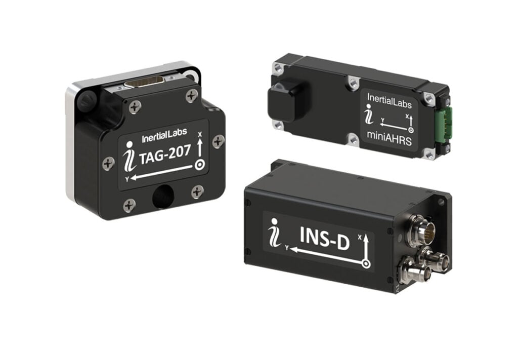
Inertial Labs outlines the integration and flight-tested performance of visual-aided inertial navigation with vision-based positioning, combining inertial measurement data with visual inputs to support accurate localization in GNSS-denied conditions
Inertial Labs has unveiled a visual-aided inertial navigation system (VINS) that enables UAVs to maintain precise navigation during GPS-denied missions, addressing rising jamming threats in global airspace
Jun 03, 2025
Advancing Unmanned Systems Through Strategic Collaboration
UST works with major OEMs to foster collaboration and increase engagement with SMEs, to accelerate innovation and drive unmanned systems capabilities forward.