Drone Swarm Weather Sensing Technology Selected by USAF

GreenSight's WeatherHive sensing technology will use autonomous nano-UAS to enable the USAF to properly forecast weather conditions By Mike Ball / 17 Nov 2022

Drone Swarm Technology

Discover cutting-edge solutions from leading global suppliers
SUPPLIER SPOTLIGHT
Drone swarm weather sensing
Follow UST

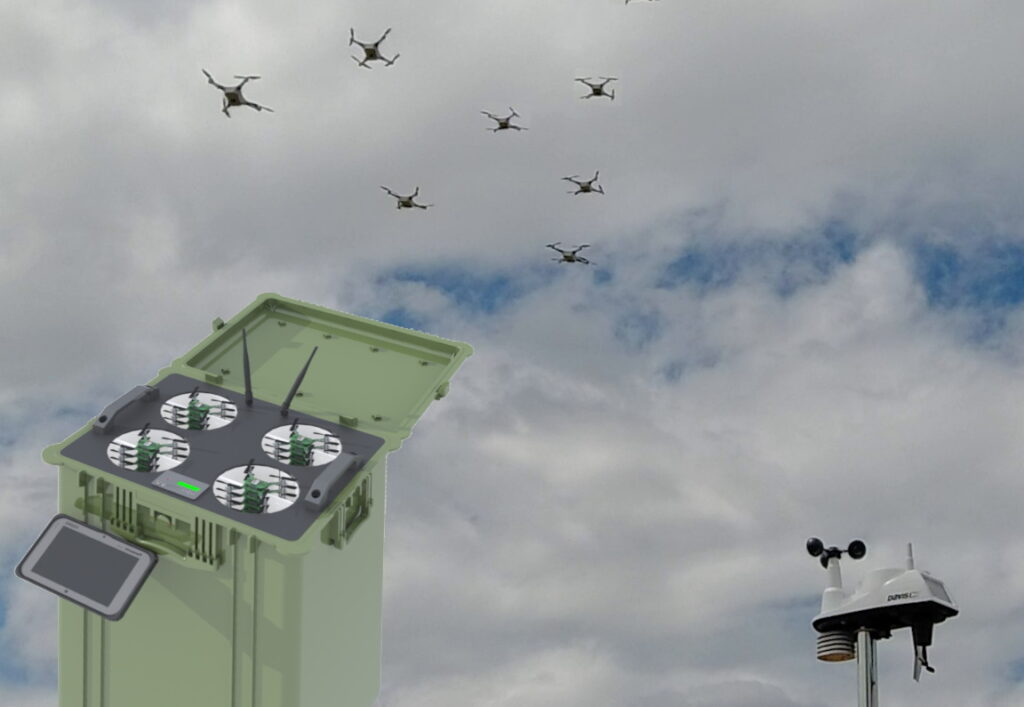
GreenSight has confirmed that its WeatherHive sensing technology has been selected by the US Air Force and the Defense Innovation Unit for incorporation into a prototype system. The technology, which was developed with the aid of funding from the National Science Foundation, uses swarms of nano-sized drones to directly measure atmospheric conditions.

The WeatherHive system can transverse up to 50 square miles per flight, generating a dense 3d cube of measurements. It provides a number of advantages over weather balloons, which can only capture data along a rising path, are fairly expensive per flight, and can only be used once leading to waste and pollution. Full-size manned aircraft may be used for data collection, but are highly cost-prohibitive for gathering large amounts of data.

The palm-sized WeatherHive nano-UAS weigh less than 150 grams and are extremely inexpensive and safe, automatically launching and landing in their “hive” for recharging and reuse. Dozens or hundreds can be used at once to gather large quantities of data regularly. Remotely deployable and disposable, WeatherHive is able to gather data in remote or contested areas, providing the capability the USAF needs to properly forecast weather conditions and inform military decision makers.

WeatherHive data shows promise to enable new breakthroughs in weather forecasting and climate science. Armed with data from WeatherHive, weather forecasting models may be able to much more accurately predict tornado formation, severe storm behavior, wildfire movement and hurricane paths.

GreenSight is developing WeatherHive using a selection of technology building blocks from the company’s robotics services platform. This suite of custom robotics hardware and software systems facilitates the development of innovative and impactful robotics technologies operating out in the real world where conditions and connectivity are not assured. GreenSight has worked with over 100 government agencies and private companies to bring their robotics and AI visions to reality.

Find manufacturers of Weather Sensing Technologies for Unmanned Systems >>

Posted by Mike Ball Mike Ball is our resident technical editor here at Unmanned Systems Technology. Combining his passion for teaching, advanced engineering and all things unmanned, Mike keeps a watchful eye over everything related to the unmanned technical sector. With over 10 years’ experience in the unmanned field and a degree in engineering, Mike’s been heading up our technical team here for the last 8 years. Connect & Contact

Latest Articles

Low- & Zero-Emission Propulsion & Power Generation Solutions for UAVs

NEX Power's hybrid propulsion technologies are designed to enable next-generation applications such as UAM and heavy-lift cargo drones

Feb 07, 2025
Most Read Articles on UST This Week

Here’s our round-up of the five most read articles on UnmannedSystemsTechnology.com this week

Feb 07, 2025
Project OPTIMAS to Utilize Schiebel VTOL UAS for Advanced Optical Laser Communications

Project OPTIMAS and Schiebel are set to develop a secure, high-speed optical communication system using quantum encryption and laser technology for multi-domain defence and satellite connectivity

Feb 07, 2025
Gemini 1200id High-Resolution Sonar Optimized for Unmanned Underwater Operations

Tritech's Gemini 1200id sonar offers high-resolution imaging, advanced noise reduction, and dual-frequency capability, enhancing performance for unmanned underwater systems and mission-critical ROV operations

Feb 07, 2025
Dockstr to Offer SubC Imaging’s Underwater Cameras & Software Solutions

SubC Imaging has announced Dockstr as its new agent, extending access to its advanced underwater cameras, DVRs, and remote operation systems across key offshore sectors worldwide

Feb 07, 2025
New NDAA-Compliant FPV Drone Camera Released 

Unusual Machines has launched the NDAA-compliant Fat Shark Aura FPV Camera, offering high-performance, first-person view capabilities for commercial and defense applications

Feb 07, 2025

Featured Content

Vertiq’s 81-08 G2 Module Added to DIU’s Blue UAS Framework

Vertiq's 81-08 G2 servo motor and control system for Group 2 sUAS has become the first motor and ESC combination to be approved under the U.S. government's Blue UAS Framework

Feb 05, 2025
Compact Remote ID Receiver Released for Enhanced Drone Safety

Dronetag has introduced RIDER, a pocket-sized, drone-agnostic Remote ID receiver designed to improve airspace situational awareness and support commercial and public safety applications

Jan 30, 2025
New GCS Software Released for C100 Quadcopter

Performance Drone Works introduces PDW CORE, a comprehensive software bundle enhancing the C100 quadcopter's capabilities with a new UI, flight simulator, mission planner, ATAK integration, and fleet management tools

Jan 29, 2025
Advanced Signal Mapping Tool Released for Effective UAV Flight Planning

Elsight has launched HeatSight, a signal strength mapping tool that provides UAV operators with reliable cellular coverage data, improving flight planning efficiency and safety for BVLOS missions

Jan 28, 2025
Doodle Labs Unveils Mobile App for Managing Mesh Networks

Doodle Labs is introducing the Mesh Rider® Mobile App, providing intuitive tools for managing wireless mesh networks across devices such as ground control stations (GCS) and UAVs

Jan 23, 2025
Advanced FOG-Based Inertial Sensing Solutions for Drones & Robotics

Aegiverse's products feature a multi-layered architecture that combines multiple elements into a compact module, providing significant, size, weight and cost reductions

Jan 21, 2025