Lightweight Dual-Camera Drone Sensor for Engineering-Class 3D Data Collection

The MACS-3D is designed to collect 3D data for vertical infrastructure and fits on small drone platforms such as the DJI M300 By Mike Ball / 28 Sep 2022

Inspection Drones

Discover cutting-edge solutions from 33 leading global suppliers
SUPPLIER SPOTLIGHT
Engineering-class 3D sensor for drones
Follow UST

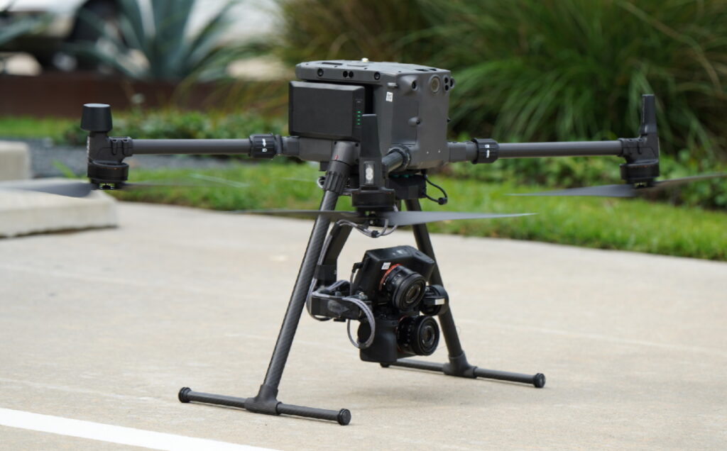
Visual Intelligence, developers of a unified drone sensor and software platform capable of digitizing physical infrastructure to millimeter accuracy, has released a lightweight version of its patented MACS-3D dual-camera sensor system. The MACS-3D is designed to collect engineering-class 3D data across all vertical infrastructure.

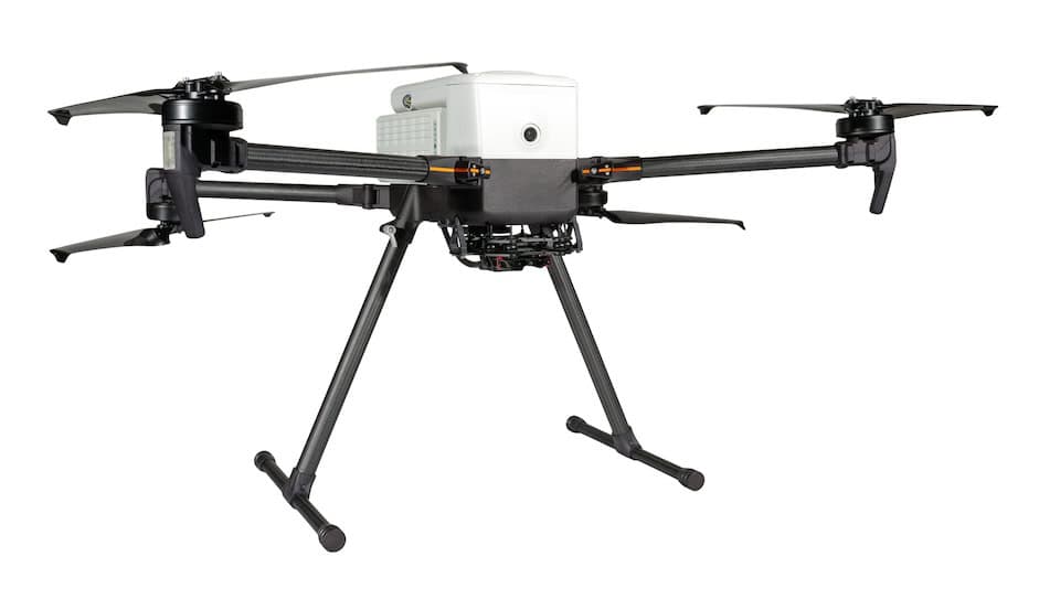
Developed to meet the demands of asset owners who require a precision 3D reality model for engineering applications, Visual Intelligence’s new MACS-3D sensor module features a compact design that fits on various drone models, and a lightweight payload that provides increased compatibility with smaller commercial-class drones – including the DJI Matrice 300. Importantly, like earlier versions, the new sensor module collects a sub-millimeter GSD to produce an emerging new category of engineering-class drone data that is both millimeter-accurate and provides near-complete surface coverage.

The lightweight MACS-3D sensor module includes dual 61-megapixel cameras (122 megapixels total) and a multiple-axis gimbal. The sensor can achieve a GSD of up to 0.5mm at 10m+ from target, and features a high Field of View (FOV) to target ratio for greater asset coverage. According to Visual Intelligence, the MACS-3D sensor is 50-100 times more accurate than standard off-the-shelf consumer drones and 10-20 times more accurate than mobile LiDAR sensors.

Key features of the new MACS-3D sensor system include:

  • New smaller payload footprint and weight
  • More point cloud detail per photo with twin 61-megapixel cameras
  • Increased pixels on target with a Field of View optimized for vertical captures
  • Simultaneous angles for increased coverage and depth
  • Safer drone flights with a farther structure standoff distance
  • Increased security with data isolation from drone manufacturer hardware
  • Customizable for various platforms and flight controllers

Ted Miller, Founder and Chairman of Visual Intelligence, commented: “The single biggest constraint to drone data accuracy is the sensor payload, and most sensor payloads cannot deliver a class of 3D data to Engineering teams that eliminates site visits or automates structural analysis. This new lighter version of our patented sensor is key to expanding access to operators for scalable engineering-grade data collections worldwide.”

Find Drone Camera manufacturers and suppliers of Cameras for UAS >>

Posted by Mike Ball Mike Ball is our resident technical editor here at Unmanned Systems Technology. Combining his passion for teaching, advanced engineering and all things unmanned, Mike keeps a watchful eye over everything related to the unmanned technical sector. With over 10 years’ experience in the unmanned field and a degree in engineering, Mike’s been heading up our technical team here for the last 8 years. Connect & Contact

Latest Articles

Most Read Articles on UST This Week

Here’s our round-up of the five most read articles on UnmannedSystemsTechnology.com this week

Apr 17, 2025
Updates on Conformal Coating & Tin Whiskers

SCS outlines updates on conformal coatings and tin whiskers, looking into the origin of tin whiskers, how to mitigate their adverse consequences with conformal coatings, and more

Apr 17, 2025
Quadratix Powers Multi-Domain UAS Operations with AI & Automation

General Atomics integrates its software expertise into Quadratix, a unified ecosystem designed to enhance multi-domain operations with AI, automation, and real-time data fusion across air, land, sea, cyber, and space, including unmanned systems

Apr 17, 2025
Integrated ROV Camera & DVR System Streamlines Visual Inspections

SubC Imaging outlines how its Rayfin SCI system simplifies underwater inspections by combining camera control and DVR functions into a single interface for ROV operators

Apr 17, 2025
ParaZero Unveils Advanced Parachute Recovery System for Critical Drone Operations

ParaZero launches the SafeAir M4, an advanced parachute recovery system designed for the DJI Matrice 4, enhancing drone safety, compliance, and mission readiness

Apr 17, 2025
The Evolution of Aurora Flight Sciences’ sUAS Platforms

Aurora Flight Sciences has spent more than ten years refining sUAS capabilities, and its evolving platforms now support a broad range of ISR missions

Apr 17, 2025

Featured Content

WarrenUAS Adds Another Top Expert in Sophisticated Unmanned Aircraft

WarrenUAS has announced a collaborative agreement with The Tactien Group, deepening its industry ties and expanding its leadership in unmanned aircraft systems training and research

Apr 15, 2025
​​​​Teledyne Marine Launches Compact Autonomous Navigation Solution at Ocean Business

Teledyne Marine has unveiled the Compact Navigator at Ocean Business 2025, an ultra-compact autonomous navigation system designed for ROVs and AUVs, optimizing size, power, and performance in a single lightweight unit

Apr 10, 2025
Greensea IQ to Present Autonomous EverClean Robot at Ocean Business 2025

Greensea IQ will introduce its hybrid EverClean Inspection Robot at Ocean Business 2025, showcasing advanced capabilities for underwater asset inspection and data collection

Apr 07, 2025
Advancing Unmanned Systems Through Strategic Collaboration UST works with major OEMs to foster collaboration and increase engagement with SMEs, to accelerate innovation and drive unmanned systems capabilities forward.