LiDAR System Introduced for Small Surveying Drones

By Caroline Rees / 18 Aug 2021

Smart Sourcing for Unmanned Systems

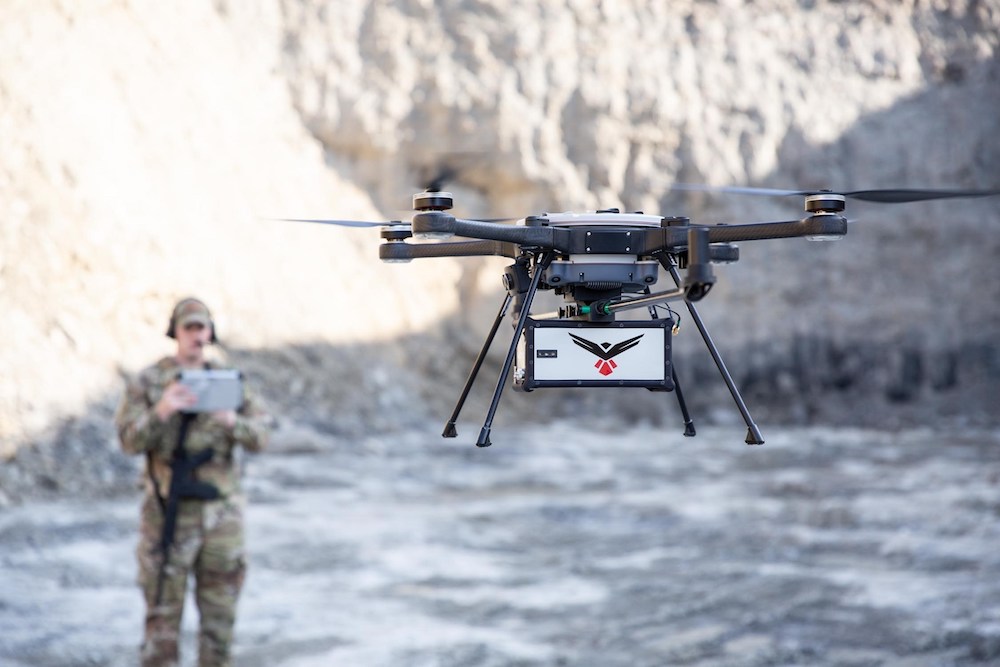
Discover cutting-edge solutions from leading global suppliers
SUPPLIER SPOTLIGHT
Follow UST

RedTail LiDAR Systems has unveiled the RTL-450 LiDAR sensor at AUVSI XPONENTIAL 2021. The RTL-450 incorporates a lightweight Microelectromechanical Systems (MEMS) mirror and a precision navigation system to generate accurate data for demanding aerial surveying missions. 

LiDAR for Small Surveying Drones

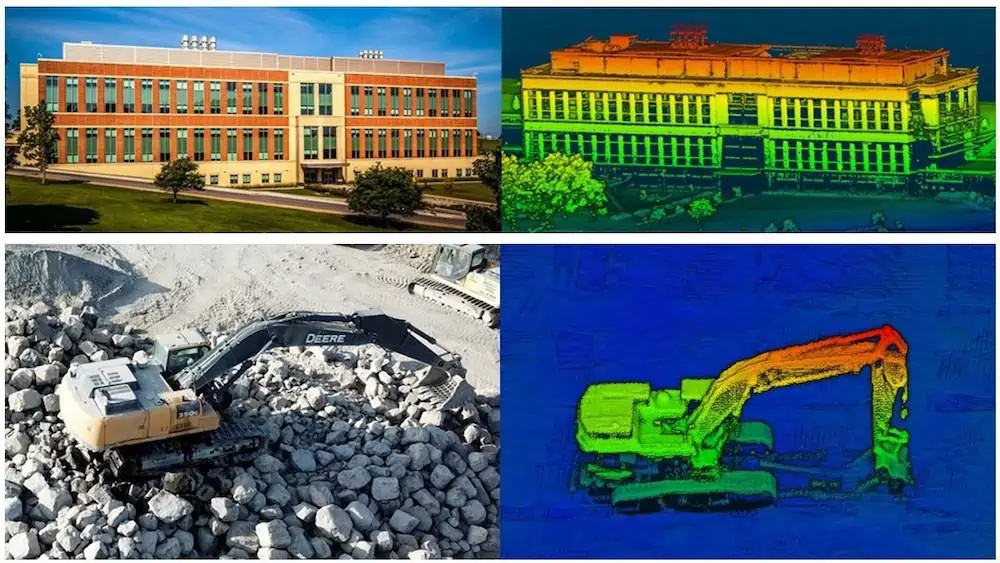
The high-resolution, 3D point clouds created by the RTL-450 give operators the ability to conduct advanced analytics of geographic and manmade features on the earth’s surface. 

Designed and assembled in the U.S., the RTL-450 incorporates patented LiDAR sensor technology for superior performance. The LiDAR system, which weighs just over 4 lbs, is designed to operate independently of a drone platform, providing great flexibility for drone integration. 

The modular design facilitates quick and efficient integration onto user selected platforms. The software interface is simple and easy to use, and also comes with a comprehensive online training curriculum. 

The system operates in a raster scan mode for surveillance missions and a side-to-side line scan mode for area mapping. The intuitive command and control, and high-brightness display integrated into the ground control station allows operators to monitor and optimize data collection missions, a unique offering in the current UAV LiDAR systems market. 

“This LiDAR system has been enhanced for use on a wide variety of small, user selected drones,” said Brad DeRoos, President and CEO of RedTail LiDAR Systems. “The innovative MEMS mirror technology ensures that drone operators create one of the best, high-quality point clouds in the industry.”

The RTL-450’s high-resolution point clouds are generated at a rate of up to 400,000 pulses per second and 5 returns per pulse. They are designed for use in numerous military, first-responder and commercial applications, including mission planning, battle damage assessment, force protection, emergency response, remote surveillance, construction and resource management, and infrastructure development. All laser pulses are transmitted toward the ground toward the area of interest. 

The high level of detail within the 3D LiDAR images makes them ideal for use with Artificial Intelligence and Machine Learning (AI/ML) algorithms for the autonomous detection and classification of objects of interest with no human intervention required. 

With 3D point clouds being created using the light from the pulsed laser, images can be collected both day and night. Receiving up to 5 returns from every light pulse transmitted enhances through canopy light transmission, thereby allowing the ground to be imaged even under heavily foliated conditions – an important capability that cannot be provided by photogrammetric imaging techniques. 

High-resolution point cloud images captured by the RTL-450

Find suppliers of LiDAR scanners, sensors & technology for Drone & UAS >

Posted by Caroline Rees Caroline co-founded Unmanned Systems Technology and has been at the forefront of the business ever since. With a Masters Degree in marketing Caroline has her finger on the pulse of all things unmanned and is committed to showcasing the very latest in unmanned technical innovation. Connect & Contact

Latest Articles

Klein Marine Systems Integrates Exail Navigation Solution into Side Scan Sonar

Klein Marine Systems has integrated Exail’s advanced AHRS into its 5900 sonar, enhancing accuracy, stability, and efficiency for demanding underwater mapping missions

Apr 24, 2025
Expanding Modular Maritime Autonomy with TSUNAMI USV Line

Textron Systems is expanding its USV capabilities with the TSUNAMI™ family, a series of modular, scalable platforms designed to meet the demands of autonomous maritime operations

Apr 24, 2025
Strategic Value of Protective Coatings in Electronic System Reliability

HZO highlights the role of protective coatings like Parylene in delivering long-term operational value for sensitive electronic components across a wide range of industries

Apr 24, 2025
Inspired Flight CEO Discusses Leadership, Innovation & the Future of Drone Technology

Inspired Flight Technologies CEO, Rick Stollmeyer, discusses advancing drone technology, highlighting innovation, leadership, and the mission of reshoring critical manufacturing to America

Apr 24, 2025
Vision-Based Traffic Detection Enhances BVLOS Safety for Xer X8 Hybrid UAV

Xer Technologies teams up with Daedalean to enhance BVLOS drone safety, integrating vision-based traffic avoidance into the robust, hybrid-electric Xer X8 multirotor drone

Apr 24, 2025
Sierra-Olympia Launches Long-Wave Infrared OGI Camera for Continuous Gas Monitoring

Sierra-Olympia Technologies unveils the Viento LWIR OGI, a cost-effective infrared camera designed for continuous, reliable gas leak detection in industrial environments

Apr 24, 2025

Featured Content

Apollo & Moonrock Launch $122.5m Drone, eVTOL Insurance Facility

Apollo and Moonrock take the lead on new $122.5m drone, eVTOL and aviation innovation insurance facility

Apr 22, 2025
ParaZero Unveils Advanced Parachute Recovery System

ParaZero launches the SafeAir M4, an advanced parachute recovery system designed for the DJI Matrice 4, enhancing drone safety, compliance, and mission readiness

Apr 17, 2025
Compact High Resolution MWIR Zoom Lens Released for UAV & ISR Platforms

MKS Instruments introduces the Ophir SupIR 10-135mm f/1.8 zoom lens, engineered for compact MWIR systems demanding long-range detection and high-resolution thermal imaging

Apr 17, 2025
Advancing Unmanned Systems Through Strategic Collaboration UST works with major OEMs to foster collaboration and increase engagement with SMEs, to accelerate innovation and drive unmanned systems capabilities forward.