The support of new smart city construction using digital twin technology enables the continuous innovation of smart urban development, uniquely combining the “virtual and real” world.
To illustrate a typical digital city project, CHC Navigation has conducted a proof-of-concept demonstration in the Jinshan District of Shanghai, China, using the AlphaUni 900 Lidar solution and collecting data via multiple platforms, including quadcopter drone and unmanned surface vessel (USV).
Read this Case Study in full here >>
Creating a Digital Twin
The creation of the digital twin city leverages high-level topographic tools capable of providing comprehensive, multi-dimensional, large-scale, high-resolution data sets. As a virtual model, a digital city provides layered data about buildings, urban infrastructure, utilities, businesses, and the movement of people and vehicles. By providing this information, digital twins enable smart city development and modernization.
Traditional methods of collecting and representing 2D spatial data, such as maps and images, are no longer sufficient, and a complete upgrade of traditional survey tools is required to move to 3D modeling. Derived 3D models can be merged and correlated with social or economic spatial data from IoT and Big Data, giving rise to a high demand for integrated solutions, allowing the capture of high accuracy 3D geospatial data in a short time frame.
Capturing 3D Point Cloud Data in Cities
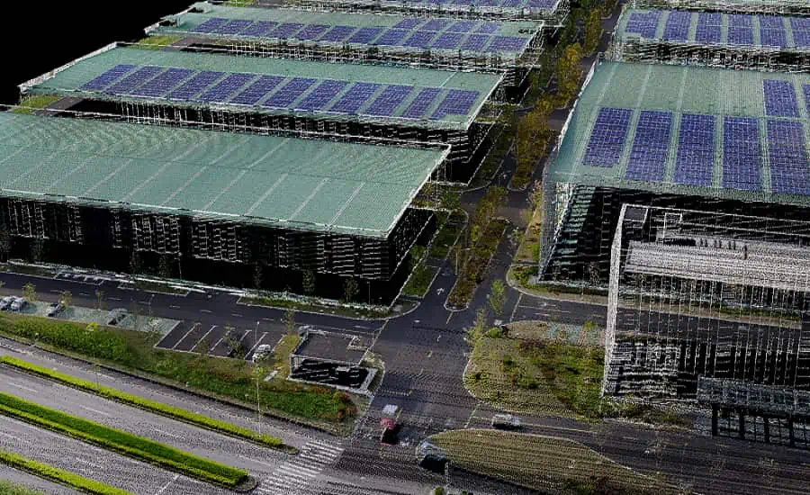
CHC Navigation chose in the Jinshan District of Shanghai, with a total area of about 600 km2, to demonstrate the AlphaUni 900 Lidar system’s seamless integration of real buildings and outdoor mapping capabilities with high-precision 3D data collection. The area is rich in terrain characteristics featured in typical large modern cities, such as high-rise buildings, power lines, rivers and vegetation.
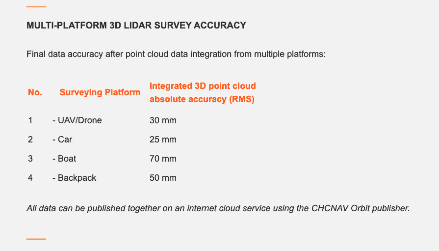
Capturing 3D geospatial data from a single platform Lidar system can leave some areas blank in the point cloud data. The AlphaUni 900 Lidar solution, with its multi-platform capability, can easily capture complete data from a drone, car, backpack or boat, and can produce a sophisticated 3D image.
Solving the Challenges of Urban 3D Laser Scanning
#1. Using terrestrial LiDAR with a versatile mobile platform
The Alpha3D provides geospatial professionals with a high-performance, vehicle-independent mobile mapping solution for capturing 3D mass data in ever-changing urban environments. Whatever the application, the Alpha3D mobile mapping system dramatically increases the return on investment by getting the work done faster and more accurately.
The Alpha3D combines an accurate, long-range, ultra-high-speed laser scanner, a high-resolution HDR panoramic camera, an advanced GNSS receiver, and a high-accuracy IMU, all in a lightweight, compact yet rugged design. All these features make the Alpha3D one of the most innovative mobile mapping systems on the market today.
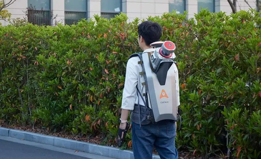
The AlphaUni 900 is a high-end, multi-platform LiDAR systems that has been designed and enhanced by CHCNAV with many years of experience in 3D data acquisition. The AlphaUni 900 is a fully integrated system with high precision, long range laser scanners featuring Riegl’s unique Waveform-Lidar technology and high accuracy inertial navigation system, ready for survey missions requiring the highest quality data in the air and on the ground. Its unique design allows it to be mounted on a backpack for narrow street scanning.
#2. 3D Scanning with a drone to access data in hard-to-reach areas
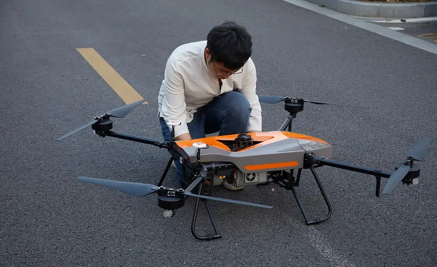
The limitation of capturing data with a single-platform LiDAR system may leave some areas blank in the point-cloud data. Mounted on an airborne drone, the AlphaUni 900 can capture complete data from an aerial perspective.
The BB4 UAV is a high-end unmanned aircraft platform resulting from an alliance between two industry leaders in their respective segments. Its scientific design and highly integrated production technology comes from CHCNAV and its fully automated flight control system from DJI.
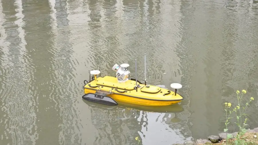
#3. Combining an overwater riverbank scan with underwater bathymetric data
The APACHE 6 USV is an integrated innovative solution able to combine high-resolution 3D bathymetric surveys and simultaneously acquire scanning data of the riverbank. Equipped with a Norbit multibeam echosounder and the AlphaUni 900, the APACHE6 scans a city’s rivers, canals and harbors in a single pass, providing high data consistency and considerable time savings.
Powered by a high-performance dual-propeller system providing a stable automatic cruise speed of up to 2.5 m/s, the APACHE6 USV improves work efficiency and produces high-resolution data to consistently meet the requirements of the most demanding 3D city model projects.
In Conclusion
During the project, the CHCNAV AlphaUni 900 seamlessly integrated city buildings into the datasets and provided sophisticated 3D images and point clouds from aerial, terrestrial and water environments. The extensive coverage of the derived 3D models has a high capacity to be merged and correlated with social, economic and infrastructure spatial data.
CHCNAV’s AlphaUni 900’s high accuracy capability and cross-platform design, successfully provided an innovative solution to the 3D geospatial data acquisition required for smart city development.