VT MÄK Launches RadarFX SAR Simulation Software

By Mike Ball / 05 Aug 2015

Smart Sourcing for Unmanned Systems

Discover cutting-edge solutions from leading global suppliers
SUPPLIER SPOTLIGHT
Follow UST

VT MAK RadarFXVT MÄK, a developer of simulation software, has announced the launch of RadarFX, the company’s new Synthetic Aperture Radar (SAR) simulation and visualization product. The software has been developed by VT MÄK in conjunction with its partner, JRM Technologies.

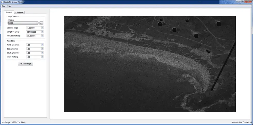
In the real world, a SAR sensor is typically attached to a manned or unmanned aircraft or a satellite. A SAR system generates photograph-like still images of a target area by combining radar return data collected from multiple antenna locations along a path of flight. Requests from users on the ground define the target area to be scanned, and other parameters used to generate and return the image.

In the simulation world, RadarFX SAR Server stands in for the SAR system. The server listens for SAR image requests from one or more client applications, and responds to those requests by generating a simulated SAR image, and providing the image to the client. A client application might be a Command and Control System running in a simulation mode, a ground station simulation, or any other simulation application that has a need to request, collect, and display SAR images.

In addition to the RadarFX SAR Server software itself, the RadarFX product distribution includes a C++ API that a client application can use to make requests of the server, and to receive responses. A sample client application, called GUI Client, has also been included to allow users to test and demonstrate the capabilities of RadarFX SAR Server without writing any custom client code. Full source code to the GUI Client is provided.

RadarFX SAR Server is built on top of MÄK’s VR-Vantage IG, and uses JRM Technologies’ proven physics-based sensor simulation technology. RadarFX utilizes the same process as MÄK’s SensorFX product for materially classifying terrain databases and 3D models. This allows it to work seamlessly with existing materially classified databases and provides 100% correlation between the different sensor views. The RadarFX SAR Server natively supports all versions of the DIS and HLA standards, making it easier to integrate into simulation programs.

Posted by Mike Ball Mike Ball is our resident technical editor here at Unmanned Systems Technology. Combining his passion for teaching, advanced engineering and all things unmanned, Mike keeps a watchful eye over everything related to the unmanned technical sector. With over 10 years’ experience in the unmanned field and a degree in engineering, Mike’s been heading up our technical team here for the last 8 years. Connect & Contact

Latest Articles

GA-ASI Spotlights Advanced Uncrewed Systems at Paris 2025

General Atomics Aeronautical Systems is internationally showcasing a full-scale model of the company’s Collaborative Combat Aircraft (CCA) at the Paris Air Show 2025 at Stand B-176, Hall 3

Jun 16, 2025
Cambridge Pixel Collaboration to Advance Police Forces C-UAS Technology

Cambridge Pixel and OpenWorks Engineering are collaborating to deliver adaptable counter-drone systems tailored for European law enforcement agencies

Jun 16, 2025
New Crewed-Uncrewed Teaming Solution for Airborne UAS Control

Airbus Helicopters has launched HTeaming, a modular crewed-uncrewed solution that enables helicopter crews to take full control of UAS while airborne

Jun 16, 2025
Neousys to Present Rugged Embedded Computers for UAVs at Paris Air Show

Neousys Technology and Factory Systemes will showcase IP69K edge AI computers and lightweight AI mission computers for drones and robotics at Paris Air Show 2025

Jun 16, 2025
New Autonomous Robot Streamlines Outdoor Data Collection Tasks

Canadian robotics company Optimotive introduces the IRIS MK2, a rugged autonomous robot built to automate data collection in demanding outdoor environments

Jun 16, 2025
Enhancing Point Cloud Accuracy with YellowScan’s New Smoothing Feature

YellowScan’s new Smoothing feature enhances point cloud data by reducing noise, improving accuracy, and preserving critical details for better geospatial analysis

Jun 16, 2025

Featured Content

MEMS DC Accelerometers from SDI Deliver Superior Performance for Unmanned Systems

SDI's MEMS DC accelerometers offer a robust solution for unmanned aerial, ground, and underwater vehicles, providing precise static and dynamic motion sensing, crucial for autonomous navigation, attitude feedback, and structural monitoring

Jun 12, 2025
Calian GNSS Unveils New Anti-Jamming CRPA with XF+ Filtering

Calian GNSS has introduced the CR8894SXF+, a compact CRPA antenna with in-band null forming and XF+ filtering for resilient GNSS performance in interference-prone environments

Jun 06, 2025
Honeywell Introduces HG3900 Tactical-Grade IMU with Enhanced Sensor Accuracy

Honeywell has introduced the HG3900 IMU, a MEMS-based device with tactical-grade accuracy, offering significant SWaP advantages for precision navigation systems

Jun 05, 2025
Advancing Unmanned Systems Through Strategic Collaboration UST works with major OEMs to foster collaboration and increase engagement with SMEs, to accelerate innovation and drive unmanned systems capabilities forward.