New UAV LiDAR Solution for Advanced Aerial Surveying Unveiled

Teledyne Geospatial and Inertial Labs have launched EchoONE, an advancement in airborne laser scanning technology that integrates LiDAR and camera technology with the Remote Sensing Payload Instrument (RESEPI) By William Mackenzie / 24 Sep 2024

Drone LiDAR

Discover cutting-edge solutions from 4 leading global suppliers
SUPPLIER SPOTLIGHT
New UAV LiDAR Solution for Advanced Aerial Surveying
Follow UST

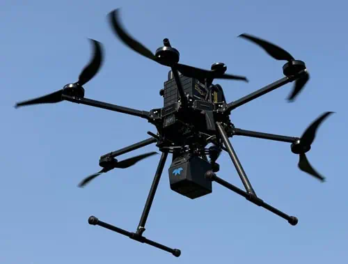
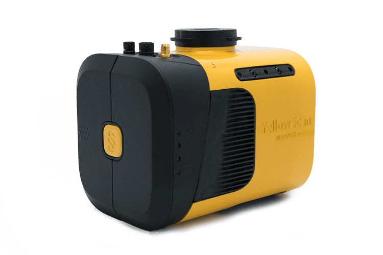
Teledyne Geospatial and Inertial Labs have launched EchoONE, a collaborative innovation that combines Teledyne’s LiDAR and camera technology with the Remote Sensing Payload Instrument (RESEPI).

Leveraging Inertial Labs’ inertial measurement unit (IMU) and inertial navigation system (INS) technology, EchoONE combines NDAA-compliant data security, lightweight design, and real-time operation.

EchoONE delivers long range, engineering-grade 3D point clouds, enhancing reliability for sensor operators in land surveying, electric utility vegetation management and asset modeling, as well as transportation and infrastructure projects.

Long-range & Lightweight
EchoONE weighs just 1.2 kg and can be operated from unmanned aerial vehicles (UAVs) such as the Freefly Astro, Inspired Flight IF800 and DJI M300/M350, while collecting engineer-grade data reliably at a regulatory limit of 120 m / 400 ft agl.

Accuracy & Speed
Full undecimated georeferenced point clouds generated in real-time allowing infield verification combined with rapid post-processing through RESEPI’s ‘one-click’ PC-Master Pro post-processing solution.

NDAA Compliant & Affordable
The affordable EchoONE ensures the integrity and confidentiality of data through compliance with stringent NDAA requirements.

Mark Treiber, Product Manager at Teledyne Geospatial, commented, “We are excited to introduce EchoONE to the market. This collaboration with Inertial Labs combines our mutual expertise to provide a powerful tool that meets the evolving needs of our customers in various industries.”

Jamie Marraccini, CEO at Inertial Labs, added, “Inertial Labs is proud to partner with Teledyne Geospatial on this innovative product. EchoONE represents a significant advancement in airborne laser scanning technology, offering unmatched performance and security.”

Find out more about EchoONE at INTERGEO 2024 in Stuttgart, Germany, September 24-26.

  • Teledyne Geospatial: Hall 1, Booth D1.002.
  • Inertial Labs: Hall 3, Booth C3.013.
Posted by William Mackenzie Edited by William Mackenzie, Junior Editor and Copywriter practised in digital content creation and writing about defense and marine technology. Connect & Contact

Latest Articles

High-Energy Density Batteries for Drones & Robotic Vehicles

The SCIO Brick® platform offers industry-leading energy density in a compact and lightweight footprint, and can be scaled to meet high-voltage requirements

Jul 12, 2025
Most Read Articles on UST This Week

Here’s our round-up of the five most read articles on UnmannedSystemsTechnology.com this week

Jul 11, 2025
Vertiq Speed Firmware v0.1.1 Now Available with Bug Fixes

Vertiq has released firmware v0.1.1 to correct a parameter bug affecting telemetry and 3D mode settings on select G1 and G2 modules

Jul 11, 2025
The Role of ROVs in Unmanned Marine Operations

Oceanbotics has answered the most common questions about ROVs, covering how they work, where they're used, and key capabilities

Jul 11, 2025
LiveU File Transfer Speeds Up Drone Data Delivery for Critical Missions

LiveU’s File Transfer enables rapid transmission of large drone data files, reducing delays and supporting faster decision-making in public safety and infrastructure operations.

Jul 11, 2025
Exploring Differences Between M9PLUS & M9 GNSS Antennas

Discover the key upgrades in Maxtena’s new M9PLUS GNSS antenna, including improved performance, signal purity, and multipath mitigation over the original M9

Jul 11, 2025

Featured Content

USAF Uses Inertial Labs Drone Lidar for Tree Obstruction Survey

The US Air Force successfully used Inertial Labs drone Lidar and cloud software to quickly map tree obstructions at Joint Base Lewis-McChord (JBLM), improving airfield safety

Jul 11, 2025
New UAV to Combine Solar Hydrogen & Battery Power for Extended Flight

XSun and H3 Dynamics are developing the first UAV powered by solar, hydrogen, and batteries, aiming to deliver zero-emission, long-endurance unmanned flight

Jul 07, 2025
Enhancing Mangrove Restoration Through 3D Printed Drone Design

Explore how Inverto Earth, in collaboration with HP Additive, is using sustainable 3D printing and drone technology to drive large-scale mangrove restoration and protect vulnerable coastal ecosystems

Jul 03, 2025
Advancing Unmanned Systems Through Strategic Collaboration UST works with major OEMs to foster collaboration and increase engagement with SMEs, to accelerate innovation and drive unmanned systems capabilities forward.