


Powerline Inspection Drones
Discover cutting-edge solutions from 4 leading global suppliers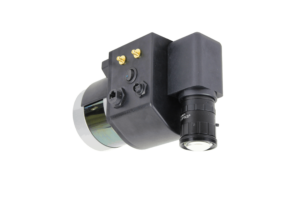 PolyExplore has developed a high-performance integrated HD aerial scanning platform that combines a dual-frequency RTK GNSS/INS with both a LiDAR sensor and a global-shutter RGB camera for centimeter-level accurate mapping and surveying. The Polyscanner is ideal for UAV (unmanned aerial vehicle)-based power line asset management and surveying.
The system includes a choice of LiDAR sensors to meet different altitude, speed and point density requirements, with a Velodyne VLP-16 or VLP-32C LiDAR as standard, and the ability to accept other survey-grade sensors as a custom option. A variety of camera options are available, with the basic system providing an 8.9 MP resolution industrial-grade global shutter camera.
Providing centimeter-level location accuracy and high-precision attitude data outputs, the embedded dual frequency RTK GNSS/INS features dual antennas, a choice of MEMS or FOG IMUs, and supports Global PPP services.
The lightweight Polyscanner provides a number of advantages for large-scale aerial power line inspection scans. Weighing only 2.5kg, it does not require a large and expensive UAV to deploy. High-speed LiDAR scanning can be performed at up to 12 m/s, allowing the system to cover large areas in a single flight. The system does not need to be calibrated before every mission, and provides up to an hour of onboard data storage, allowing users to spend more time flying the mission with fewer interruptions.
The Polyscanner system is easy to assemble and deploy, with an intuitive and simple workflow. Post-processing is performed with PolyExplore’s sensor fusion software, providing fast geo-annotation and colorization.
The following images from an aerial power line inspection scan, performed at 10m/s ground speed, demonstrate the capabilities of the Polyscanner system:

Aerial scan of the intersection of transmission and distribution powerlines

HD scan of multiple distribution powerlines in an urban area

Transmission power lines with two types of towers

Transmission powerlines with vegetation

Colorized point cloud for the vegetation along the power line


