Microdrones UAV Operates Inside Controlled Airspace

By Mike Ball / 11 Jun 2020

Smart Sourcing for Unmanned Systems

Discover cutting-edge solutions from leading global suppliers
SUPPLIER SPOTLIGHT
Follow UST

Microdrones mdMapper1000DG UAS

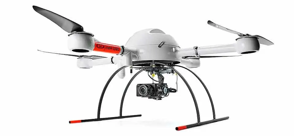
Microdrones has released a study detailing the use of their mdMapper1000DG UAS (unmanned aerial system) mapping solution to create topographic maps of areas inside the Hartsfield-Jackson Atlanta International Airport, one of North America’s busiest airports.

Read the full case study on Microdrones’ website

Brent Scarbrough & Co. Inc., a Georgia-based civil construction company, required an overview of the state of an on-hold expansion project at the airport, and turned to the expertise of UAV data collection services provider Flyover Services. A fully integrated Microdrones mdMapper1000DG system was selected for the project, which received the proper planning and authorization to fly in areas between the ninth and tenth runways at the airport.

Flyover Services originally carried out projects such as these under the FAA Section 333 guidelines, and now operate with airport authorities on LAANC (Low Altitude Authorization and Notification Capability). The FAA have recently expanded LAANC to increase access for drone pilots into controlled airspace, and currently about 600 airports are covered by the capability.

The mdMapper1000DG UAS was ideal for the project due to its maneuverability in tight spaces, as well as its use of DG (Direct Georeferencing), a highly efficient method for connecting aerial images to their geographic positioning on the Earth’s surface. All the required data was captured in three flights spanning a total time of 80 minutes. The drone’s payload was a Sony RX1R II camera with APX-15 IMU (inertial measurement unit).

The pilots were able to capture accurate contours across three different areas that were combined into a single map. According to Flyover Services, the highly efficient Microdrones UAS was able to accomplish in half a day what would have taken a traditional survey team operating in hazardous areas up to a week.

To find out more about Microdrones’ UAS solutions for mapping in complex environments such as airports, read the full case study here.

Posted by Mike Ball Mike Ball is our resident technical editor here at Unmanned Systems Technology. Combining his passion for teaching, advanced engineering and all things unmanned, Mike keeps a watchful eye over everything related to the unmanned technical sector. With over 10 years’ experience in the unmanned field and a degree in engineering, Mike’s been heading up our technical team here for the last 8 years. Connect & Contact

Latest Articles

Most Read Articles on UST This Week

Here’s our round-up of the five most read articles on UnmannedSystemsTechnology.com this week

Jun 20, 2025
New AI Emission Detector for Autonomous Drones Enables Remote Methane Monitoring

Percepto has introduced an AI-powered emission detection system that combines autonomous drones and real-time analytics to streamline methane monitoring and regulatory compliance for oil and gas operators

Jun 20, 2025
CRP Technology Receives ISO 14001:2015 Environmental Certification for Additive Manufacturing

CRP Technology has obtained ISO 14001:2015 certification from DNV, covering its additive manufacturing processes and confirming alignment with international environmental management standards

Jun 20, 2025
Chess Dynamics Demonstrates Advanced AI Tracking in Challenging Field Trials

Chess Dynamics has demonstrated its advanced AI tracking technology in demanding multi-domain trials, showcasing reliable target tracking, classification and sensor performance in complex conditions

Jun 20, 2025
Marine Laboratory Advances Shallow Water Mapping with RIEGL Bathymetric LiDAR

Plymouth Marine Laboratory is advancing shallow water mapping using RIEGL's UAV-mounted bathymetric LiDAR, enabling high-resolution, low-impact environmental data collection and research

Jun 20, 2025
Evolito to Develop Electric Propulsion System in New Aerospace Collaboration

Evolito and VÆRIDION have partnered to develop electric propulsion technology for the Microliner aircraft, aiming to deliver improved propulsion efficiency and operational safety

Jun 19, 2025

Featured Content

Exail Showcases Integrated USV & AUV Operations in Collaborative Trial

Exail’s DriX USV and Ifremer’s Ulyx AUV were jointly deployed for the first time, demonstrating advanced cooperative capabilities in deep-sea exploration

Jun 19, 2025
HBK Updates RTK Service for Precise Positioning in Autonomous Systems

HBK has updated its SensorCloud RTK service, integrating with MicroStrain by HBK navigation systems to provide centimeter-level accuracy and simplified deployment for autonomous systems

Jun 17, 2025
MEMS DC Accelerometers from SDI Deliver Superior Performance for Unmanned Systems

SDI's MEMS DC accelerometers offer a robust solution for unmanned aerial, ground, and underwater vehicles, providing precise static and dynamic motion sensing, crucial for autonomous navigation, attitude feedback, and structural monitoring

Jun 12, 2025
Advancing Unmanned Systems Through Strategic Collaboration UST works with major OEMs to foster collaboration and increase engagement with SMEs, to accelerate innovation and drive unmanned systems capabilities forward.