


Discover World-Leading Unmanned and Autonomous Technologies
Discover cutting-edge solutions from leading global suppliers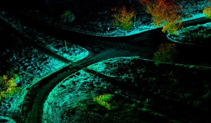
OxTS, a developer of inertial sensing solutions for UAVs (unmanned aerial vehicles) and robotics, has released a case study detailing how the company’s xNAV250 inertial navigation system (INS) has been used to enable LiDAR scanning capabilities for mapping and surveying firm Dronezone’s family of UAVs.
Read the full case study on OxTS’ website
Dronezone required an integrated INS solution that could be easily interfaced with the Velodyne VLP-16 LiDAR system in order to allow their custom-built drones to quickly gather data and produce highly accurate and reliable pointclouds. GNSS and IMU data would need to be combined with the output from the LiDAR scanner to produce a georeferenced pointcloud from the aerial scan. Dronezone also needed a solution that would be easy to configure and require no custom software development.
The xNAV250 was an ideal match, with its roll/pitch accuracy of 0.05°, RTK/PPK position accuracy of 0.02m and 2m baseline heading accuracy of 0.1°. Dronezone also utilised OxTS’ Georeferencer LiDAR data georeferencing software, and NAVsuite post-processing software.
Dronezone tested its new integrated drone LiDAR solution in multiple scenarios, including mapping of 45 km of road. Using their previous method, this project would have taken Dronezone approximately five days. With the xNAV250 and VLP16 they were able to reduce this time by over 50%, while also improving accuracy and modelling a true 3D representation of the environment.
To find out more about how OxTS’ inertial navigation solutions can deliver improved flexibility and accuracy for applications such as drone LiDAR scanning, read the full case study on OxTS’ website.


