


Commercial Drones
Discover cutting-edge solutions from 31 leading global suppliers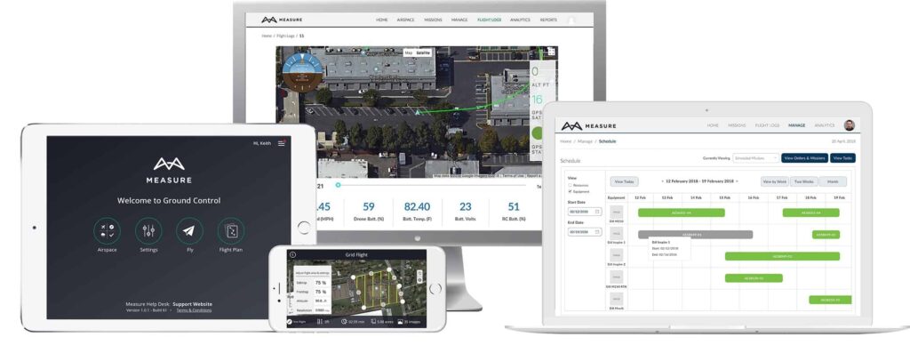
Measure, a provider of enterprise drone services, has announced the launch of its next generation drone software platform, Ground Control 2.0. Over 200 companies around the world have already leveraged the platform as new features and functions have been added, and it is now available to the public after upgrading current Ground Control users.
“We are in a pivotal time in the drone industry, as companies are scaling their operations and seeking a compliant solution backed by a company with an incredible amount of real-world experience unmatched in the industry,” says Measure CEO, Brandon Torres Declet. “We are excited to continue to serve clients with a powerful drone program management tool that we intend on continuously improving as regulations and technology advance.”
Measure Ground Control 1.0 was launched with an easy-to-use flight application developed specifically for commercial use and a cloud-based web portal where managers could check airspace and view flight logs and data screen shots automatically uploaded from drone missions. Measure Ground Control 2.0 adds powerful program management capabilities and new flight application features designed to provide ROI to corporate drone programs.
With Ground Control 2.0, enterprises can:
Manage People & Equipment by:
- Keeping tabs on the activities, certifications, and training of your team
- Assigning roles to provide user access to just the right information
- Managing all equipment, with automatic usage tracking and maintenance recommendations
Schedule & Plan Flights by:
- Creating and scheduling missions, and managing a program-wide calendar
- Assigning pilots, equipment, and other resources to missions
- Setting flight parameters and paths to be sent to pilots in the field
Fly & Collect Data by:
- Checking weather and airspace and requesting LAANC authorization
- Using active track modes including spotlight, POI, trace, and profile
- Setting up automated grid and waypoint flights
Track & Report Activity by:
- Reviewing automatically uploaded flight logs, screen captures, and completed checklists
- Checking automatically flagged incidents for activity outside of safety best practices
- Viewing interactive dashboards of program activity and exporting reports for compliance tracking
Store & Use Data by:
- Storing unlimited flight logs, drone data, and reports on a secure, US-based server
- Uploading inspection results to create summarized, program-wide dashboards
- Integrating with GIS tools, data visualization software, and ERP systems
A complete list of features can be found at https://www.measure.com/ground-control.
Energy company AES has already been using Ground Control as it scales its own enterprise drone program in 13 countries worldwide.
“We see great value in Ground Control’s worldwide flight management, starting with in-flight safety risk notifications and mapping of restrictive areas,” notes Evaristo Leonardi, VP Global Operations Support at AES. “Our pilots enjoy its ease of use and our operators appreciate the automatic uploads of imagery which they use to extract valuable insights to improve our operations and safety.”
“We believe Ground Control is a crucial tool for building drone operations to scale,” says Jesse Stepler, Chief Strategy Officer at Measure. “We will be a driving factor in the advancement of the drone industry in energy, construction, public safety, government, and other organizations where drone use is widespread. As these organizations look to increase operational efficiency, Ground Control offers complete oversight and control as a truly all-encompassing tool for enterprise drone programs.”


