Airobotics Integrates LiDAR into Drone Solutions

By Mike Ball / 31 Jan 2019

Smart Sourcing for Unmanned Systems

Discover cutting-edge solutions from leading global suppliers
SUPPLIER SPOTLIGHT
Follow UST

Airobotics drone

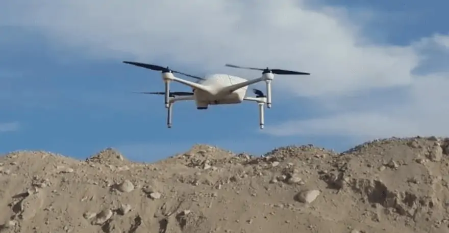
Airobotics, a developer of automated drone solutions, has announced that it has integrated LiDAR capabilities into its UAV (unmanned aerial vehicle) systems, which until a few years ago was only possible with a manned aircraft as the sensors were hefty and required manual data processing. With modern technology, LiDAR images are captured and processed quickly in the cloud, allowing Airobotics’ customers to make effective decisions based on high-frequency, consistent data capture.

Airobotics’ LiDAR capabilities provides rapid precision scans across the value chain for industries such as mining and construction. Applications typically involve tailing dams monitoring, infrastructure inspections, haul road safety compliance, stockpile volume analytics, tracking rehabilitation progress, and more.

The use of LiDAR significantly reduces the time it takes for aerial data to be collected, even at night or in low light, and allows for rapid turn-around time on data processing. Airobotics’ drones can work with various payloads. In addition to LiDAR, spatial data can also be captured using photogrammetry, video, and infra-red (thermal).

One recent application of Airobotics’ new capabilities was the generation of a LiDAR elevation model of a stockpile at a mining site using an Optimus drone flight. After collecting raw data using LiDAR, professionals are able to remove above-the-ground information, such as heavy machinery, vegetation and people without having to physically remove them. Ultimately, this allows for access to proper data scans of the areas.

“This past year has seen a huge period of growth for us,” said Airobotics CEO and Co-Founder, Ran Krauss. “As we expand our services and shift our base of operations to the US, we continue to push advancements in autonomous drone operations, global regulatory approvals and new technology.”

Airobotics recently obtained Australia’s first and only Civil Aviation Safety Authority (CASA) approval to operate automated multi-rotor drones from its Remote Operations Center (ROC) beyond visual line of sight (BVLOS) with no aircrew needed at the client site. It is also the first company in the US to receive a Certificate of Waiver (CoW) from the FAA that combines three elements: flying Beyond Visual Line of Sight (BVLOS) for automated drone operations, over human beings, with a visual observer that is not required to keep a visual line of sight on the drone. This waiver permits Airobotics to operate drones from the company’s Remote Operations Center in Scottsdale.

Posted by Mike Ball Mike Ball is our resident technical editor here at Unmanned Systems Technology. Combining his passion for teaching, advanced engineering and all things unmanned, Mike keeps a watchful eye over everything related to the unmanned technical sector. With over 10 years’ experience in the unmanned field and a degree in engineering, Mike’s been heading up our technical team here for the last 8 years. Connect & Contact

Latest Articles

SightLine Software & Hardware Advancements for Enhanced ISR Applications

SightLine Applications LLC introduces the 3.9.2 update, enhancing the 4100 video processor and unveiling the ultra-compact 1710 processor for advanced ISR applications

Jul 16, 2025
Silicon Sensing’s MEMS Technology Enhances Vehicle Localization for Autonomous Driving

The University of Toronto investigated approaches to determining spatial awareness in autonomous vehicles, with Silicon Sensing's DMU41 IMU succeeding in cost-effectiveness, reliability and accuracy

Jul 16, 2025
CHC Navigation Launches AU20 MMS for Precision LiDAR Mapping of Infrastructure

CHC Navigation (CHCNAV) has unveiled the AU20 MMS, a vehicle-mounted mobile mapping system designed for accurate and efficient collection of 3D spatial data

Jul 16, 2025
ZIYAN to Highlight UAV Coordination & Unmanned Helicopter Solutions at IDEF 2025

ZIYAN Tech will unveil its latest combat UAV technologies at IDEF 2025, highlighting advanced swarm coordination, ISR systems, and unmanned helicopter capabilities

Jul 16, 2025
Boosting First Responder Drones with Advanced BVLOS Technology

DroneSense and MatrixSpace partner to enhance BVLOS capabilities, accelerating the safe, scalable use of drones in public safety and Drone as First Responder missions

Jul 16, 2025
TEKEVER Advancing Defense & Civil Security Drones with Cahors Centre of Excellence

Tekever will establish a new dual-use Centre of Excellence in Cahors, France to develop, test, integrate and industrialize autonomous defense and security technologies

Jul 16, 2025

Featured Content

SBG Systems Evaluates INS Performance in GNSS-Denied Marine Applications

SBG Systems evaluates the performance of its INS solutions in GNSS-denied marine environments, comparing system accuracy with and without DVL and warm-up support

Jul 14, 2025
USAF Uses Inertial Labs Drone Lidar for Tree Obstruction Survey

The US Air Force successfully used Inertial Labs drone Lidar and cloud software to quickly map tree obstructions at Joint Base Lewis-McChord (JBLM), improving airfield safety

Jul 11, 2025
New UAV to Combine Solar Hydrogen & Battery Power for Extended Flight

XSun and H3 Dynamics are developing the first UAV powered by solar, hydrogen, and batteries, aiming to deliver zero-emission, long-endurance unmanned flight

Jul 07, 2025
Advancing Unmanned Systems Through Strategic Collaboration UST works with major OEMs to foster collaboration and increase engagement with SMEs, to accelerate innovation and drive unmanned systems capabilities forward.