US Coast Guard Tests UAS-Mounted ViDAR For Search Missions

By Mike Ball / 03 Oct 2016

Smart Sourcing for Unmanned Systems

Discover cutting-edge solutions from leading global suppliers
SUPPLIER SPOTLIGHT
Sentient ViDAR demo
Follow UST

Sentient ViDAR demo

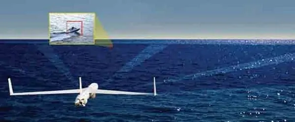
Sentient, a developer of computer vision solutions, has announced the successful completion of its live demonstration of ViDAR with the US Coast Guard. The trial was conducted off Cape Cod, MA, over a week with a team from the USCG Research and Development Centre, Hood Technologies and TacAero. The demonstration highlighted ViDAR’s capability to find objects of interest at great distance, whilst searching over wide tracts of ocean from a small unmanned aircraft system (UAS).

The demonstration was part of the Coast Guard’s continuing evaluation of small UAS technologies and sensors currently available in the commercial market.

“Detection is critical to bringing reliability to the surveillance task. With limited size and power, small and tactical UAS are heavily constrained in what they can carry and are often therefore limited to observing what has already been found,” said Simon Olsen, Sentient’s Director of Business Development, Strategy and Partnerships. “ViDAR is the first technology with the ability to conduct wide area search from a small/tactical UAS.”

The US Coast Guard demonstration of ViDAR involved an exhaustive series of search flights designed to find vessels and objects representative of Coast Guard missions. The targets were placed in the search area at locations unknown to the ViDAR operator.

Highlights from the demonstration include ViDAR successfully, and autonomously, detecting a fast boat at 17.7nm, a life raft at 3.7nm, a person in the water at 1.9nm and a shipping vessel at over 33nm. Each time ViDAR detected an object, a small image was sent to the ground automatically; allowing the operator to move from initial detection, to classification and identification in seconds.

ViDAR comprises a high-resolution digital camera that continuously scans the ocean in a 180-degree arc in front of the air vehicle. The ViDAR software autonomously detects any object on the surface of the ocean, providing the ground control station with an image and location coordinate of each object detected in real time. The zoom-able spotter sensor can then be cross-cued to the object for closer inspection, while ViDAR continues to provide ongoing situational awareness.

Find suppliers of Cameras & Imaging Systems >

Operating in effect like an optical radar, ViDAR enables a wide field of view, resulting in over 80 times ocean coverage compared with existing optics.

Posted by Mike Ball Mike Ball is our resident technical editor here at Unmanned Systems Technology. Combining his passion for teaching, advanced engineering and all things unmanned, Mike keeps a watchful eye over everything related to the unmanned technical sector. With over 10 years’ experience in the unmanned field and a degree in engineering, Mike’s been heading up our technical team here for the last 8 years. Connect & Contact

Latest Articles

Elistair’s Tethered Drone System Integrated into Autonomous Port Security Project

Elistair's tethered drone system will provide continuous surveillance of ports from an autonomous vessel as part of the European SMAUG project

Jun 12, 2025
MEMS DC Accelerometers from SDI Deliver Superior Performance for Unmanned Systems

SDI's MEMS DC accelerometers offer a robust solution for unmanned aerial, ground, and underwater vehicles, providing precise static and dynamic motion sensing, crucial for autonomous navigation, attitude feedback, and structural monitoring

Jun 12, 2025
AWI Completes First Under-Ice Dive in the Arctic with an ecoSUB AUV

The Alfred Wegener Institute (AWI) has completed the first under-ice deployment of ecoSUB's smallest autonomous underwater vehicle (AUV) the ecoSUB-µ5 during a mission in Arctic conditions

Jun 12, 2025
SatLab Geosolutions Introduces HydroBoat 1200MB Integrated USV Survey Solution

SatLab Geosolutions’ new HydroBoat 1200MB combines USV technology and the HydroBeam M2 sonar for real-time 3D surveys, offering fast deployment, high efficiency, and reduced operational costs

Jun 12, 2025
Trillium Unveils Lightweight Imaging System for Medium & Long-Range Reconnaissance

Trillium Engineering introduces the HD45-LV-R, a lightweight, high-performance imaging system designed to enhance LRR and MRR reconnaissance missions for modern defense platforms

Jun 12, 2025
How to Select the Right IMU for UAV Applications

GuideNav outlines the critical considerations for selecting an IMU that matches your UAV’s performance, durability, size, and mission requirements

Jun 12, 2025

Featured Content

Calian GNSS Unveils New Anti-Jamming CRPA with XF+ Filtering

Calian GNSS has introduced the CR8894SXF+, a compact CRPA antenna with in-band null forming and XF+ filtering for resilient GNSS performance in interference-prone environments

Jun 06, 2025
Honeywell Introduces HG3900 Tactical-Grade IMU with Enhanced Sensor Accuracy

Honeywell has introduced the HG3900 IMU, a MEMS-based device with tactical-grade accuracy, offering significant SWaP advantages for precision navigation systems

Jun 05, 2025
TEKEVER Invests £400 Million to Advance UK Defense & Drive AI Innovation

TEKEVER is investing £400 million in UK defense innovation, creating 1,000+ jobs and advancing AI, autonomy, and electronic warfare through its five-year OVERMATCH program

May 29, 2025
Advancing Unmanned Systems Through Strategic Collaboration UST works with major OEMs to foster collaboration and increase engagement with SMEs, to accelerate innovation and drive unmanned systems capabilities forward.