Discover World-Leading Unmanned and Autonomous Technologies
Discover cutting-edge solutions from leading global suppliers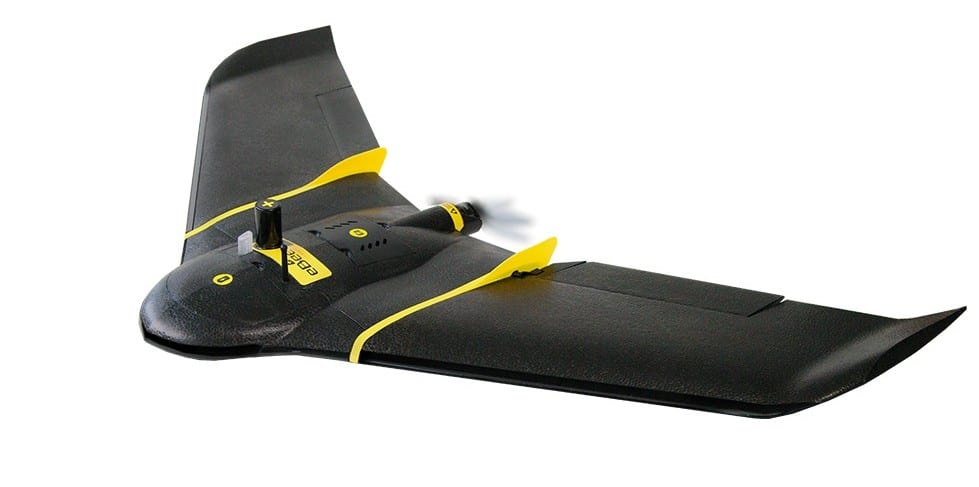
senseFly, a producer of professional mapping drones, has released details of its next-generation fixed-wing UAS for survey-grade photogrammetric mapping, the eBee Plus, which will be officially launched at INTERGEO 2016 in Hamburg, Germany.
“The eBee Plus system is the ultimate tool for geospatial organisations that demand photogrammetric-quality mapping,” said senseFly’s CEO, Jean-Christophe Zufferey. “With its unique upgradeable RTK/PPK functionality and flight time of almost an hour, this simple, largely automated solution is perfect for professionals working in fields such as surveying, construction and GIS who require a highly efficient method of data collection with survey-grade accuracy.”
The eBee Plus offers geospatial professionals 3 key benefits:
- Large coverage for optimal efficiency: the eBee Plus can map more hectares per flight than any drone in its weight class
- High Precision on Demand (HPoD): the eBee Plus includes built-in RTK/PPK functionality, activated immediately or later on demand, for survey-grade accuracy that the operator controls
- Project-perfect payloads: a camera is available to suit every application, including the new senseFly S.O.D.A. (supplied)
Built upon senseFly’s proven, safety-focused autopilot technology, the eBee Plus features three component parts, each developed with photogrammetric mapping in mind:
- eBee Plus — a light, rugged fixed-wing drone with elongated wingspan for stable, long-duration flights of close to one hour
- Compact senseFly S.O.D.A. sensor — senseFly’s proprietary, high-resolution RGB camera. This features a 1-inch sensor & global shutter, and is capable of capturing ultra-sharp images with a spatial resolution of 2.9 cm (flying at 122 m/400 ft AGL)
- eMotion 3 flight & data management software — the next-generation of senseFly’s ground station software, featuring a full 3D flight environment, mission block flight planning, and cloud connectivity
The eBee Plus features High Precision on Demand (HPoD), the drone’s built-in upgrade path to real-time and post-processing correction (RTK/PPK) functionality. Once activated by the user, this enhancement boosts the system’s achievable horizontal/vertical absolute accuracy to 3 cm/5 cm without the need for ground control points.
Designed to meet the demands of professionals whose bottom lines depend on maximising daily flight time and data collection, the eBee Plus flies for almost an hour, across a range of conditions and altitudes. Therefore, it can document 220 ha (540 ac) in a single 122 m/400 ft flight. The system’s maximum single-charge coverage (flying significantly higher above ground level) is 40 square kilometres or 15.4 square miles.
The drone’s supplied eMotion 3 software boosts an operator’s efficiency still further through the inclusion of pre-programmed mission blocks, which make planning flight lines and altitudes an automated one-click task. eMotion 3 also includes: multi-flight missions (so users need only swap the battery and hand-launch again to continue their project); multi-zone flights (for the simple mapping of complex sites); the importation of elevation models; live weather updates; and automatic terrain-adapted 3D flight planning.
“The eBee Plus system is a smart investment for any organisation interested in the efficient collection of its geospatial data. Plus, thanks to the system’s range of optional cameras, operators have the flexibility to tackle virtually any mapping job,” said Zufferey.
Specifically, the eBee Plus can carry the full line of senseFly fixed-wing RGB, thermal and multispectral sensors, including the recently introduced Parrot Sequoia for agricultural work and the thermoMAP for producing thermal maps. The drone’s camera bay also accepts existing eBee payloads, while the senseFly S.O.D.A. is itself backward-compatible with operators’ existing eBee and eBee RTK drones. eMotion 3, meanwhile, can also be used to manage the flights and data of all senseFly UASs, both fixed-wing and rotary.