


Discover World-Leading Unmanned and Autonomous Technologies
Discover cutting-edge solutions from leading global suppliers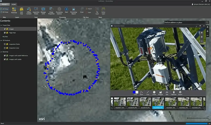
Drone2Map Inspection Viewer
Aeryon Labs have confirmed that the application can be used to process data from their SkyRanger sUAS within the Esri platform.
By combining images from the Aeryon SkyRanger with Drone2Map for ArcGIS, users can create ready-to-use GIS imagery and turn their UAS and the data it collects into a powerful productivity tool. Drone2Map for ArcGIS streamlines the creation of professional imagery products from drone-captured still imagery for visualization and analysis in ArcGIS. It allows the user to create orthomosaics, 3D meshes and more.
“Novices and experts alike can use Drone2Map to process still imagery captured by drones and use that imagery right away,” said Lawrie Jordan, director of imagery at Esri. “Processing imagery used to be complicated and take days or even weeks. Now it can be done on the fly. By adding imagery to a map, people gain that next level of situational awareness.”
Drone2Map offers in-field rapid imagery processing that allows the pilot to confirm that the drone’s flight has captured imagery of the full area of interest, reducing the need for costly return trips to the field. The app detects camera and sensor parameters, then intelligently applies appropriate defaults. The photogrammetry engine in Drone2Map is powered by Pix4D, an industry leader in professional image processing software.
“Drones can travel places that may be dangerous for people, and they prove a more affordable alternative to conventional means of image capture,” Jordan said. “With Drone2Map, on-demand imagery can be used in ArcGIS to provide a clear, accurate picture of any asset or area.”
With this release of Drone2Map, users will be able to
- Create orthomosaics, 3D meshes, and more.
- Build products with 2D and 3D mapping templates.
- Make scene layer packages from textured meshes and share them as a scene layer.
- Toggle between 2D and 3D views.
- Work offline in a disconnected environment.
- Register multiple portals for adding and sharing content.
- Download a portion of a basemap for offline use.
- Import and create ground control points for data accuracy.


