EagleView Announces the Launch of CONNECTExplorer Visualization Software

By Mike Ball / 22 Oct 2015

Smart Sourcing for Unmanned Systems

Discover cutting-edge solutions from leading global suppliers
SUPPLIER SPOTLIGHT
Follow UST

Pictometry CONNECTExplorer
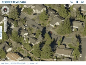
EagleView Technology Corporation, a provider of aerial imagery and GIS solutions, has announced the launch of CONNECTExplorer by its subsidiary Pictometry. CONNECTExplorer is a web-based application that allows users to view and analyze their physical environment without having to leave the office.

Building on Pictometry’s CONNECT platform – a visualization, analytical and delivery platform for utilizing and interacting with Pictometry Intelligent Imagery – CONNECTExplorer adds improved functionality and ease of use. As the dominant product within the CONNECT platform, CONNECTExplorer provides a consistent user experience across the entire CONNECT family of applications.

The software also provides users with the experience of viewing all types of Pictometry imagery including obliques, standard and AccuPLUS orthomosaics, EarlyAccess imagery as well as third- party mosaics. Developed for scalability, CONNECTExplorer offers the ability to bring in several types of imagery and data with intent for the future ability to import and analyze UAS or drone imagery and 3D models.

“The release of CONNECTExplorer demonstrates our commitment to be on the forefront of the latest image deployment and analytical platform technologies,” said Frank Giuffrida, EVP Engineering. “With imagery collection moving beyond traditional aircraft platforms combined with the demand for access to more immediate information CONNECTExplorer is the key to continued success in deriving data and answers from imagery.”

Access to CONNECTExplorer is administered through a clean rights management interface called CONNECTAdmin, allowing administrators to easily manage and deploy CONNECT on various levels, from departmental to individual settings. Leading GIS layer publishing and subscription tools as well as enhanced query and search options provide administrators with an easy and streamlined interface that simplifies the management of GIS layers for multiple users.

Find suppliers of Modelling Software >

Posted by Mike Ball Mike Ball is our resident technical editor here at Unmanned Systems Technology. Combining his passion for teaching, advanced engineering and all things unmanned, Mike keeps a watchful eye over everything related to the unmanned technical sector. With over 10 years’ experience in the unmanned field and a degree in engineering, Mike’s been heading up our technical team here for the last 8 years. Connect & Contact

Latest Articles

Gremsy Unveils Advanced Payload & Gimbal Solutions at Japan Drone 2025

Gremsy showcased its latest gimbal and payload innovations at Japan Drone 2025, marking a strategic entry into Japan’s highly demanding drone market

Jun 18, 2025
How Parylene Coatings Address PCB Corrosion Risks in Critical Devices

Specialty Coating Systems (SCS) details how corrosion in printed circuit boards (PCBs) can compromise critical systems, and explains the protective role of Parylene coatings

Jun 18, 2025
UAV Navigation-Grupo Oesía to Advance Autonomy in European VTOL Defense Drones

UAV Navigation-Grupo Oesía will supply critical autonomous navigation technology for Europe’s VANTAGE project, advancing next-gen VTOL drone capabilities for defense operations

Jun 18, 2025
Small Propeller-Driven UAS Launched Effect for Uncrewed Operations

General Atomics Aeronautical Systems has unveiled the PELE, a versatile, semi-autonomous uncrewed launched effect with 7 hour endurance, optimized for use on the MQ-9B SkyGuardian®, that can also be launched from the ground

Jun 18, 2025
Product Spotlight: ACM1000 MEMS Sensor for Multi-Parameter Vibration Monitoring

Micro-Magic outlines the capabilities of its ACM1000 digital MEMS vibration sensor, engineered for high-accuracy monitoring with multi-parameter outputs and robust performance in demanding environments

Jun 18, 2025
FPV Drone Showcased in Live Military Demonstration

Astra Systems has demonstrated its advanced Arbiter 1A FPV drone to the U.S. Army, showcasing tactical agility, ISR capabilities, and battlefield readiness

Jun 18, 2025

Featured Content

HBK Updates RTK Service for Precise Positioning in Autonomous Systems

HBK has updated its SensorCloud RTK service, integrating with MicroStrain by HBK navigation systems to provide centimeter-level accuracy and simplified deployment for autonomous systems

Jun 17, 2025
MEMS DC Accelerometers from SDI Deliver Superior Performance for Unmanned Systems

SDI's MEMS DC accelerometers offer a robust solution for unmanned aerial, ground, and underwater vehicles, providing precise static and dynamic motion sensing, crucial for autonomous navigation, attitude feedback, and structural monitoring

Jun 12, 2025
Calian GNSS Unveils New Anti-Jamming CRPA with XF+ Filtering

Calian GNSS has introduced the CR8894SXF+, a compact CRPA antenna with in-band null forming and XF+ filtering for resilient GNSS performance in interference-prone environments

Jun 06, 2025
Advancing Unmanned Systems Through Strategic Collaboration UST works with major OEMs to foster collaboration and increase engagement with SMEs, to accelerate innovation and drive unmanned systems capabilities forward.