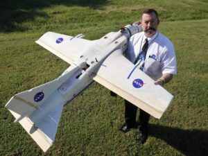
NASA’s research in unmanned aerial systems (UAS) may soon provide a means for early detection and mitigation of fires in the Great Dismal Swamp National Wildlife Refuge, a nearly 50,000-square-acre region centered on the Virginia-North Carolina border.

NASA researcher Mike Logan plans to use this small unmanned aerial vehicle to check for fires at a Virginia-North Carolina wildlife refuge as part of an agreement with the U.S. Fish and Wildlife Service
NASA’s Langley Research Center, in nearby Hampton, Virginia, has signed a one-year agreement with the Department of the Interior’s U.S. Fish and Wildlife Service (FWS) to test small UASs for the detection of brush and forest fires. The research is part of the NASA Aeronautics Research Mission Directorate’s UAS Integration in the National Airspace System (NAS) project.
“The U.S. Fish and Wildlife Service is evaluating the feasibility of airborne unmanned platforms and their ability to offer a safer and more cost-effective alternative for surveillance of potential areas of interest immediately following thunderstorm activity,” said Great Dismal Swamp Refuge Manager Chris Lowie. “The agency hopes to see a significant decrease in cost to survey the Great Dismal Swamp, as well as a reduction in time to detect nascent fires, which could potentially save millions of dollars to the taxpayer in firefighting costs,” added Lowie.
Mike Logan, the research lead at Langley, came up with the idea after a forest fire in 2011 that lasted almost four months and cost more than $10 million to extinguish. Smoke from that fire, which was caused by a lightning strike, traveled as far north as Maryland only three years after another $10-million blaze in 2008, according to FWS.
“I made a phone call to the local fire captain after days of inhaling peat bog smoke,” said Logan. “I learned most fires are caused by lightning strikes and the only way they can spot them is by hiring an aircraft to do an aerial survey of the huge swamp. So I figured why not use a UAV as a fire detector?”
After approval from the Federal Aviation Administration, the team at Langley plans to fly a lightweight UAS equipped with cameras and transmitters over the wildlife refuge.
“One is an out-of-the-nose camera that can see smoke plumes as they are rising,” Logan explained. “The other is an infrared camera housed in the body of the plane that points down. It can find hot spots by detecting heat signatures.”
Although the aircraft can fly as fast as 40 miles an hour, when used in this capacity it will be flown slower while it transmits video, allowing individuals on the ground to observe what is occurring in the live video. The transmissions can be viewed on a laptop computer in a mobile ground station.
Logan says the drone, which weighs about 15 pounds and has an almost six-foot wingspan, has a range of about eight miles and can stay aloft as long as an hour, before the batteries need recharging. The aircraft also can be programmed to fly on its own, but a safety pilot will monitor operations during the tests.
“This kind of application for unmanned aerial systems shows just one public benefit,” said Dave Hinton, Langley associate director for UAS technologies and applications. “They can be used to detect fires or locate people who are lost.”


