


Discover World-Leading Unmanned and Autonomous Technologies
Discover cutting-edge solutions from leading global suppliers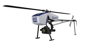
ING Robotic Aviation’s Responder rotary-wing UAS
ING Robotic Aviation is partnering with ASG Mapping to rigorously assess and develop the application of small robotic aircraft systems for gathering high quality, positionally accurate, and interoperable geospatial data.
This project is focused on the emerging commercial applications for robotic aircraft equipped with advanced sensors in agriculture, forestry, planimetry, and environmental management. For this specific operation, ING Robotic Aviation’s rotary-wing aircraft system, Responder, equipped with either optical or multispectral sensors will be used to conduct the research. There will be multiple flight operations in Ontario and Quebec covering a range of ecosystems.
The data and imagery collected in this project by Responder will be evaluated against scientific and industry standards in the fields of remote sensing and geomatics. The sensors being used to collect and process the data will be the Nikon D800 for topographical mapping and the TetraCam Mini-MCA 6 for vegetation mapping. The goal of this project is to ultimately produce a best practices guide for using small robotic aircrafts in geomatics applications.
ING Robotic Aviation and ASG Mapping have worked together in the past, having previously developed a Digital Elevation Model of a planned subdivision and also collected multispectral data of a forested area with Responder.


