senseFly Launch eBee Ag UAS for Precision Agriculture

By Caroline Rees / 22 Apr 2014

Smart Sourcing for Unmanned Systems

Discover cutting-edge solutions from leading global suppliers
SUPPLIER SPOTLIGHT
Follow UST

senseFly eBee Ag DroneSwiss mini-drone manufacturer senseFly has launched the eBee Ag, a fully autonomous aerial imaging drone (or UAV) for precision agriculture applications.

The eBee Ag is lightweight and highly durable, featuring a wide range of camera options and fully autonomous operation – flying, acquiring images, and landing itself.

“The eBee Ag enables growers and coop consultants to become much more precise in their work,” says Jean-Christophe Zufferey, C.E.O. of senseFly. “The detail provided by its customised cameras and its software’s index calculations allow customers to analyse crop conditions remotely and in high detail. This means less time wasted on manual checks and less reliance on low-resolution satellite images or costly airplane shots. With the accurate and timely data the eBee Ag supplies, farmers can optimise their crop management and chemical usage – saving them time, saving them money, and helping them boost their yields.”

Agricultural Drone Launch

The eBee Ag features a range of camera options to suit different applications, from biomass estimation to yield monitoring and leaf area indexing. It is supplied with a customized Canon S110 NIR; however, customers can also choose a customised S110 RE (red edge) version, a S110 RGB, or the Airinov multiSPEC 4C (offering four distinct bands with no spectral overlap).

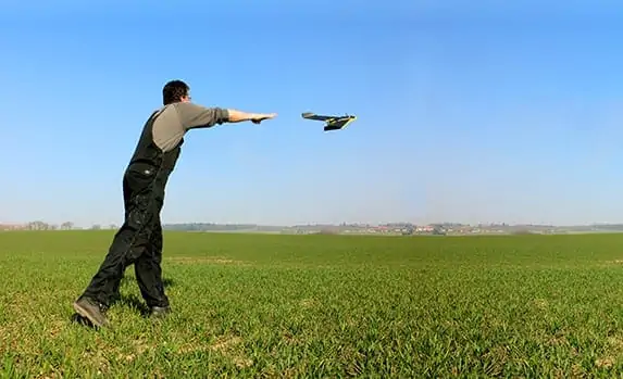
The aircraft’s onboard artificial intelligence and robust lightweight construction ensure it will survive numerous flights (and landings), thus safeguarding a customer’s investment. eBee is fully autonomous, therefore customers are able to simply select the area they want to map (using the supplied eMotion 2 software), launch the drone by throwing it into the air, and the eBee flies, acquires images, and lands all by itself.

The eBee Ag is supplied with two advanced software packages: eMotion 2 for flight planning and control; and Postflight Terra 3D photogrammetry software for post-flight image processing and analysis. Postflight Terra 3D can be used to produce false-colour orthomosaics and 3D models. Plus it includes a handy index computation tab, which allows customers to select a band, calculate NDVI, or input custom formulas in order to create the exact maps they require.

With its maximum flight time of 45 minutes, the eBee Ag can photograph areas of up to 1,000 ha (2,470 ac) in a single flight. Its default 12 MP NIR camera is capable of shooting aerial imagery at down to 2 cm (0.7 in) / pixel. These images are then easily transformed into false-colour orthomosaics using Postflight Terra 3D software, with accuracy of down to 3 cm (1.18 in). This market-leading performance brings farmers the data they need to monitor crops more precisely, feed other precision agriculture technologies, and continue improving their management decisions.

Posted by Caroline Rees Caroline co-founded Unmanned Systems Technology and has been at the forefront of the business ever since. With a Masters Degree in marketing Caroline has her finger on the pulse of all things unmanned and is committed to showcasing the very latest in unmanned technical innovation. Connect & Contact

Latest Articles

Most Read Articles on UST This Week

Here’s our round-up of the five most read articles on UnmannedSystemsTechnology.com this week

Apr 17, 2025
Updates on Conformal Coating & Tin Whiskers

SCS outlines updates on conformal coatings and tin whiskers, looking into the origin of tin whiskers, how to mitigate their adverse consequences with conformal coatings, and more

Apr 17, 2025
Quadratix Powers Multi-Domain UAS Operations with AI & Automation

General Atomics integrates its software expertise into Quadratix, a unified ecosystem designed to enhance multi-domain operations with AI, automation, and real-time data fusion across air, land, sea, cyber, and space, including unmanned systems

Apr 17, 2025
Integrated ROV Camera & DVR System Streamlines Visual Inspections

SubC Imaging outlines how its Rayfin SCI system simplifies underwater inspections by combining camera control and DVR functions into a single interface for ROV operators

Apr 17, 2025
ParaZero Unveils Advanced Parachute Recovery System for Critical Drone Operations

ParaZero launches the SafeAir M4, an advanced parachute recovery system designed for the DJI Matrice 4, enhancing drone safety, compliance, and mission readiness

Apr 17, 2025
The Evolution of Aurora Flight Sciences’ sUAS Platforms

Aurora Flight Sciences has spent more than ten years refining sUAS capabilities, and its evolving platforms now support a broad range of ISR missions

Apr 17, 2025

Featured Content

WarrenUAS Adds Another Top Expert in Sophisticated Unmanned Aircraft

WarrenUAS has announced a collaborative agreement with The Tactien Group, deepening its industry ties and expanding its leadership in unmanned aircraft systems training and research

Apr 15, 2025
​​​​Teledyne Marine Launches Compact Autonomous Navigation Solution at Ocean Business

Teledyne Marine has unveiled the Compact Navigator at Ocean Business 2025, an ultra-compact autonomous navigation system designed for ROVs and AUVs, optimizing size, power, and performance in a single lightweight unit

Apr 10, 2025
Greensea IQ to Present Autonomous EverClean Robot at Ocean Business 2025

Greensea IQ will introduce its hybrid EverClean Inspection Robot at Ocean Business 2025, showcasing advanced capabilities for underwater asset inspection and data collection

Apr 07, 2025
Advancing Unmanned Systems Through Strategic Collaboration UST works with major OEMs to foster collaboration and increase engagement with SMEs, to accelerate innovation and drive unmanned systems capabilities forward.