Nepal Tests UAV for Wildlife Crime Prevention

By Caroline Rees / 12 Sep 2012

Smart Sourcing for Unmanned Systems

Discover cutting-edge solutions from leading global suppliers
SUPPLIER SPOTLIGHT
Follow UST

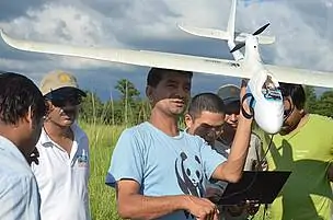
WWF has supported Nepal with training rangers to use unmanned aerial vehicles to monitor for poachers.

Nepal’s antipoaching efforts received a major boost this week as park rangers and army personnel learn how to operate unmanned aerial vehicles (UAVs) in two national parks in a training program organized by WWF.

Nepal is home to rhinos, tigers and elephants, among the world’s most vulnerable species. Poaching of these and many other animals is at an all-time high and the hope is that UAV technology will help capture poachers in the act and deter others from even trying.

“Nepal is committed to stopping wildlife crime, which is robbing Nepal of its natural resources, putting the lives of rangers and local communities at risk, and feeding into global criminal networks,” said General Krishna Acharya, Director of Nepal’s Department of National Parks and Wildlife Conservation. “Technologies like these non-lethal UAVs could give our park rangers a vital advantage against dangerously armed poachers.”

Nineteen park rangers and Nepal army personnel were trained to use the UAVs by developer Mr. Lian Pin Koh, an ecologist at the Swiss Federal Institute of Technology Zurich. Participants learned how to use the planes and conducted field tests in Bardia National Park.

Traditionally, effective monitoring of national parks has depended largely on accessibility of the terrain by anti-poaching patrols as well as prior intelligence on poachers in the vicinity.

The UAV gives the patrols a new strategic advantage with an eye in the sky, allowing them access into previously unreachable areas and a safe view of illegal activities on the ground. The presence of a UAV also serves as a deterrent to poachers and illegal loggers since they now know that the parks are being monitored both on the ground and from above.

The GPS-enabled FPV Raptor model planes are light enough to be launched by hand, filming the ground below with a still or video camera. They can fly a pre-programmed route of about 30km at a maximum elevation of 200 meters for up to 50 minutes. The battery can be recharged in about half an hour. Each UAV costs about $2500, making it affordable even for developing countries like Nepal.

“WWF is excited to be part of this field test of new technology in partnership with the government of Nepal,” said Anil Manandhar, Country Representative of WWF Nepal. “We see this as a potentially powerful new tool to improve protection of Nepal’s national parks from illegal activities like poaching and logging.”

Posted by Caroline Rees Caroline co-founded Unmanned Systems Technology and has been at the forefront of the business ever since. With a Masters Degree in marketing Caroline has her finger on the pulse of all things unmanned and is committed to showcasing the very latest in unmanned technical innovation. Connect & Contact

Latest Articles

UK MOD Validates PDW C100 for Aerial Target Designation

Performance Drone Works (PDW) demonstrated the capabilities of its C100 quadcopter for the UK MOD, successfully designating targets with precision and completing extended-range missions during a live-fire event in Texas

Jul 09, 2025
SatLab Showcases Geospatial Technologies at CSPI-EXPO 2025

SatLab attended CSPI-EXPO 2025 in Chiba, Japan from 18-21 June, showcasing its latest innovations across the full spectrum of geospatial solutions

Jul 09, 2025
DeltaQuad Collaboration to Boost VTOL Surveillance Drone Production

DeltaQuad has partnered with VDL Groep to expand production of its Evo surveillance drone, enhancing manufacturing capabilities to meet rising defence sector demand

Jul 09, 2025
FarSounder Argos Powers Autonomous Navigation on Unmanned Surface Vessel

FarSounder’s Argos sonar technology has been integrated into DARPA’s NOMARS vessel, advancing autonomous navigation and situational awareness in unmanned maritime operations

Jul 09, 2025
Impact of Jamming & Spoofing on GNSS Positioning

Tersus GNSS explains how jamming and spoofing interfere with GNSS signals, outlines their distinct impacts, and presents technical strategies for detection and mitigation

Jul 09, 2025
ESA Feasibility Study to Advance Autonomous Drone Landing Without GPS

Agilica completes an ESA-backed study advancing precision drone landing tech that works without GPS, targeting urban, maritime, and complex autonomous UAV operations

Jul 09, 2025

Featured Content

New UAV to Combine Solar Hydrogen & Battery Power for Extended Flight

XSun and H3 Dynamics are developing the first UAV powered by solar, hydrogen, and batteries, aiming to deliver zero-emission, long-endurance unmanned flight

Jul 07, 2025
Enhancing Mangrove Restoration Through 3D Printed Drone Design

Explore how Inverto Earth, in collaboration with HP Additive, is using sustainable 3D printing and drone technology to drive large-scale mangrove restoration and protect vulnerable coastal ecosystems

Jul 03, 2025
Partnership Combines Drone Swarms & Situational Awareness to Boost Wildfire Response

Kongsberg Geospatial and FireSwarm Solutions have partnered to integrate autonomous drone swarms with real-time situational awareness for faster, smarter wildfire response

Jun 30, 2025
Advancing Unmanned Systems Through Strategic Collaboration UST works with major OEMs to foster collaboration and increase engagement with SMEs, to accelerate innovation and drive unmanned systems capabilities forward.