New LiDAR Systems Released for Survey-Grade Mapping

ROCK Robotic’s R3 and R3 PRO are surveying tools designed to capture unprecedented, accurate 3D LiDAR and photogrammetry data for commercial land surveyors and mapping professionals By Caroline Rees / 25 Apr 2023

Drone LiDAR

Discover cutting-edge solutions from 4 leading global suppliers
SUPPLIER SPOTLIGHT
ROCK Robotic
Follow UST

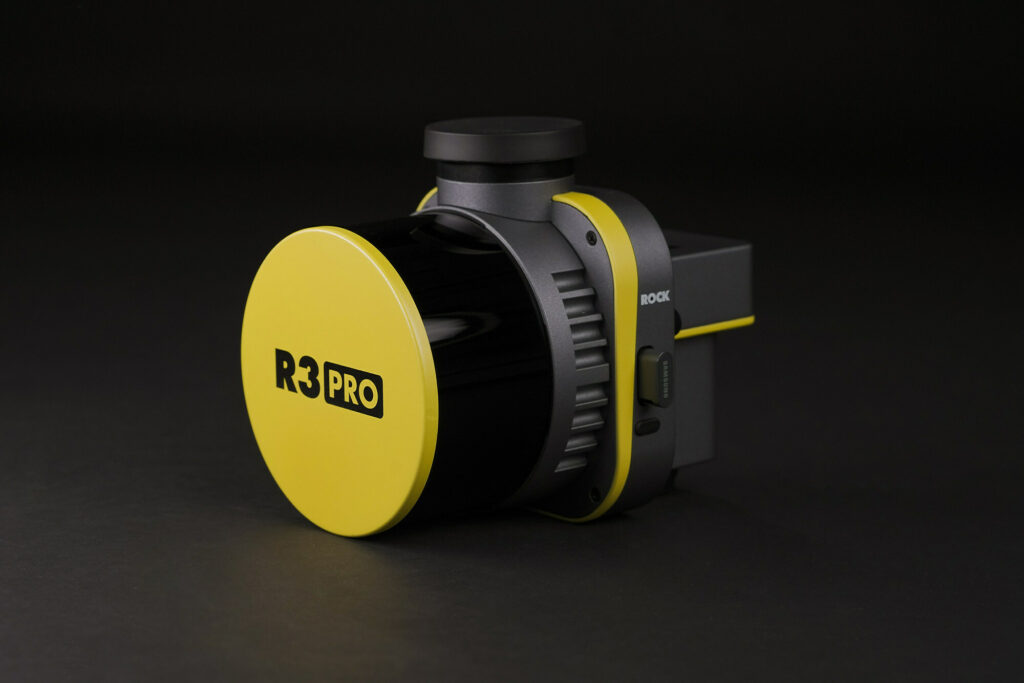
ROCK Robotic has released the R3 LiDAR mapping systems product line, introducing sophisticated hardware components into a lightweight, integrated 3D point cloud collection tool. 

The launch of the R3 and R3 PRO is the latest effort for ROCK Robotic to offer a user-friendly, end-to-end LiDAR solution to land surveyors and commercial mapping professionals.

The new ROCK R3 includes cutting-edge technology, including a geodetic-grade GNSS receiver and tactical-grade IMU. The R3 PRO comes equipped with a Hesai Pandar XT32 sensor, while the lower pricepoint R3 utilizes the Hesai Pandar XT16 sensor. The R3 includes a detachable 26MP camera for high-resolution RGB image capture. It weighs just 1.26 kg (2.77 lb) compared to the previous ROCK 360 system’s 1.70 kg (3.74 lb). In addition, the R3 offers optional advanced SLAM capabilities for mapping on the ground, as well as in areas with weak GNSS signals.

ROCK Robotic CEO Harrison Knoll, said: “The ROCK R3 PRO is a major step forward for ROCK Robotic. It offers better accuracy, better SLAM, a better camera, a lighter payload — basically a better product all around. Not only will our current customers love it, but we’re confident that the R3 will attract new customers who want a great hardware product along with our great software and support.”

“We want surveyors and mapping professionals to have the simplest workflow while getting the best results and deliverables,” Knoll added. “From the time you’re out in the field flying your drone to when you send deliverables to your client, ROCK makes it as easy as possible to make it happen. With the recently released ROCK Desktop software, R3 system and ROCK Cloud post-processing software, we’ve got all the bases covered. ROCK is definitely stepping up as a major player in the LiDAR arena.”

Find manufacturers of LiDAR for aerial survey and mapping>>

Posted by Caroline Rees Caroline co-founded Unmanned Systems Technology and has been at the forefront of the business ever since. With a Masters Degree in marketing Caroline has her finger on the pulse of all things unmanned and is committed to showcasing the very latest in unmanned technical innovation. Connect & Contact

Latest Articles

Most Read Articles on UST This Week

Here’s our round-up of the five most read articles on UnmannedSystemsTechnology.com this week

Mar 21, 2025
Ukrainian Drones to Receive Free Cyber Security

To support the drones and unmanned systems involved in the Ukrainian war effort, Periphery is donating its military-grade threat management expertise and software for IoT devices

Mar 21, 2025
Neousys Technology on the Rise of AI Drone Pilots

Learn how Neousys' FLYC-300 NVIDIA® Jetson edge AI computer enhances drone performance by optimizing flight paths, overcoming GPS challenges, and improving efficiency for various applications

Mar 21, 2025
High-Assurance Cryptography Devices Reach Delivery Milestone

Viasat’s encryption team has surpassed 100K high-assurance cryptography devices delivered to government customers, proactively defending the clients’ data communications

Mar 21, 2025
Septentrio Joins Hexagon to Advance Autonomy & Mission-Critical Positioning

Hexagon has acquired Septentrio, a manufacturer of GPS/GNSS positioning technology, to strengthen its autonomy and mission-critical applications, enhancing accessibility to high-accuracy positioning solutions

Mar 21, 2025
New Payload Command and Control Introduced by GA-ASI

TacSit-C2 is a new payload command and control system by GA-ASI which integrates diverse sensor data into a single, intuitive interface

Mar 20, 2025

Featured Content

How IONA Reaches the Last Mile Through Smart Product Development

In this webinar, learn from Drone Industry Insights about scaling production and supply chain challenges, strategies from Arena by PTC to optimize product development, and how IONA Drones are advancing last-mile delivery

Mar 18, 2025
Nokia Talks to UST about 4G/5G Connected Drone-in-a-Box Advancements

How Nokia is revolutionizing drone connectivity with 4G and 5G, and advancing autonomous operations with the cutting-edge drone-in-a-box solution; Nokia Drone Networks

Mar 16, 2025
Ascent AeroSystems Launches AI-Enabled Sub-250g Coaxial Nano UAV

Ascent AeroSystems has unveiled HELIUS, a sub-250g AI-enabled UAV designed for law enforcement, emergency response, and industrial use, offering a compact, NDAA-compliant alternative to existing systems

Mar 13, 2025
Advancing Unmanned Systems Through Strategic Collaboration UST works with major OEMs to foster collaboration and increase engagement with SMEs, to accelerate innovation and drive unmanned systems capabilities forward.