


Discover World-Leading Unmanned and Autonomous Technologies
Discover cutting-edge solutions from leading global suppliers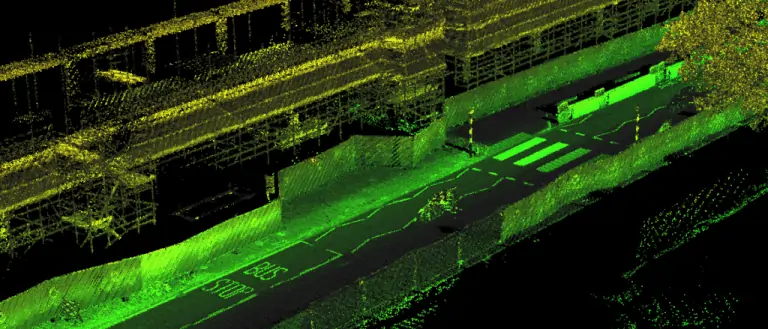
OxTS, a developer of inertial sensing solutions for UAVs (unmanned aerial vehicles) and robotics, has authored the following article explaining the fundamental principles behind pointclouds, collecting them via LiDAR, and using GNSS-aided INS for georeferencing.
What is a pointcloud?
A pointcloud is a collection of points in 3D space, with each point being given a coordinate in Cartesian convention. The points can also be given other properties, which will often be indicative of how they were obtained. Examples might include the time at which they were ‘seen’ by the surveying device that collected the data, or the intensity or error in position. Pointclouds obtained during a survey will commonly consist of around 100 million points. Photography can also be overlaid on pointclouds using photogrammetry techniques to essentially build 3D photography.
The principal method of collecting pointcloud data is by using LiDAR, a technology that works similarly to radar but uses reflections of small wavelength lasers instead of large wavelength radiowaves. Distance is calculated using the speed of light and the measured time taken for the laser pulse to return to the sensor. Typically, a LiDAR device will contain lasers with a fixed vertical angle that spin around in the horizontal plane. Internally, the device knows at what angle the laser is pointing vertically and its azimuth angle. This gives the device the position of the point on the object in 3D spherical coordinates. The lasers inside produce thousands of points per second. The intensity of a particular point is the intensity of the reflected beam, and indicates the reflectivity of the object.
What is a georeferenced pointcloud?
LiDAR requires navigation data to conduct a survey. This data is combined with the LiDAR data to create a georeferenced pointcloud. LiDAR devices know where points are in relation to themselves, but they need to be told where they are in the world to be able to build a pointcloud while moving the LiDAR. The navigation data often comes from an inertial navigation system (INS). An INS is a sophisticated combiner of inertial measurement unit (IMU) and global navigation satellite system (GNSS) data to get the best navigation data – so a device knows where it is in the world and how it is moving. The coordinates from the INS are added vectorially to the point coordinates of the LiDAR to get the final coordinates that would be used in the pointcloud. This process allows LiDAR devices to be installed on a UAV of other moving vehicle with an INS and survey large areas efficiently instead of performing multiple static surveys and stitching them together.
What are pointclouds used for?
There are a wide range of applications for which pointclouds can be used. They are increasingly used in real time to allow robots and autonomous driving computers to understand their environment and navigate through it. The data in a pointcloud is convenient for recognizing and identifying surfaces and objects; for example, other cars, roadsigns and lane markings. OxTS is fundamentally involved in helping car manufacturers get the navigation data they require to go with LiDAR data in autonomous vehicle development, and in pointcloud creation for use in surveying.
Distances and volumes are easy to calculate using pointcloud analysis software, and intensity can help identify different materials. Another feature that LiDAR offers is multi-returns. This allows a laser pulse (which has a finite cross-section) to bounce back off of multiple surfaces to give multiple points from the same pulse. This is particularly useful for detecting windows and seeing through them, and also for a myriad of other uses such as seeing the top of a treeline or the ground when flying with a UAV. LiDAR can also be used to measure snow depth, as it can see the top layer of snow as well as the ground beneath.
At OxTS we see LiDAR pointclouds being used for driverless car and work vehicle development, coastal and forest management, infrastructure monitoring (signs, drains, bridges, road surfaces, railroads, etc), creating 3D models of cities, pipeline exploration and more. The final product is a simple file format, for which the possibilities are almost endless – and we see new applications using pointclouds all the time.


