Case Study: LiDAR Mapping Workflow with UAVs

By Mike Ball / 12 Mar 2019

Mapping Drones

Discover cutting-edge solutions from 20 leading global suppliers
SUPPLIER SPOTLIGHT
Follow UST

Microdrones UAV lidar mapping

Microdrones, in conjunction with multi-discipline engineering design and consulting firm ESP Associates, has launched a new series of three videos, showcasing their LiDAR mapping workflow of Plan, Fly, Process & Visualize. In the videos, which can be viewed below, ESP Associates follows the Microdrones workflow to deliver the best possible solutions while cutting costs, saving time, and completing projects more easily.

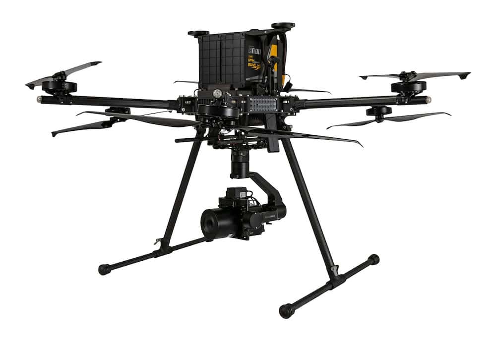
The workflow centres around Microdrones’ mdLiDAR3000 UAS (unmanned aerial system), which integrates their md4-3000 aerial platform with a RIEGL miniVUX-1UAV LiDAR sensor and a Sony RX1RII camera.

Chuck Dorgan, Microdrones Sales Director-Americas, explained that operating the mdLiDAR3000 can be easily accommodated by sticking to the workflow. “You’re using our Microdrones airframe which is steady, robust, and very rugged. So, you’re using the information you collected in your PLAN in mdCockpit, to FLY autonomously, and then you’re able to easily PROCESS & VISUALIZE the collected data to generate the point cloud.”

Brian Flaherty, a Survey Manager for ESP Associates, sees the acquisition of the mdLiDAR3000 as a win-win for their clients and for his team. He said: “We’re able to certify the data and get it to the customer faster. That allows the developer to turn around their investment on the property faster, too.”

Plan

Dorgan commented: “Using our mdCockpit software, it makes it very easy to plan your mission. The software allows you to update the mission into the md4-3000 airframe and help you plan everything autonomously. That allows you to focus on the task at hand and collect the information needed.”


Fly

In the video, Chad Bolebruch, Survey Crew Chief for ESP Associates demonstrates the setup and operation of the mdLiDAR3000. He says, “In your mission editor, you really just trace out an area with your finger and it draws live onto the screen. From there, you can set your elevation, how tight you want your overlapping, and the hatching you want to fly.”


Process & Visualize

Dorgan explained: “Our mdLiDAR solution is much faster to be able to get from collecting the data to being able to generate the point cloud. Best of all, that final point cloud is created in the standard ASPRS LAS format which is usable in any GIS or CAD software environment.”

Posted by Mike Ball Mike Ball is our resident technical editor here at Unmanned Systems Technology. Combining his passion for teaching, advanced engineering and all things unmanned, Mike keeps a watchful eye over everything related to the unmanned technical sector. With over 10 years’ experience in the unmanned field and a degree in engineering, Mike’s been heading up our technical team here for the last 8 years. Connect & Contact

Latest Articles

High-Energy Density Batteries for Drones & Robotic Vehicles

The SCIO Brick® platform offers industry-leading energy density in a compact and lightweight footprint, and can be scaled to meet high-voltage requirements

Jul 12, 2025
Most Read Articles on UST This Week

Here’s our round-up of the five most read articles on UnmannedSystemsTechnology.com this week

Jul 11, 2025
Vertiq Speed Firmware v0.1.1 Now Available with Bug Fixes

Vertiq has released firmware v0.1.1 to correct a parameter bug affecting telemetry and 3D mode settings on select G1 and G2 modules

Jul 11, 2025
The Role of ROVs in Unmanned Marine Operations

Oceanbotics has answered the most common questions about ROVs, covering how they work, where they're used, and key capabilities

Jul 11, 2025
LiveU File Transfer Speeds Up Drone Data Delivery for Critical Missions

LiveU’s File Transfer enables rapid transmission of large drone data files, reducing delays and supporting faster decision-making in public safety and infrastructure operations.

Jul 11, 2025
Exploring Differences Between M9PLUS & M9 GNSS Antennas

Discover the key upgrades in Maxtena’s new M9PLUS GNSS antenna, including improved performance, signal purity, and multipath mitigation over the original M9

Jul 11, 2025

Featured Content

USAF Uses Inertial Labs Drone Lidar for Tree Obstruction Survey

The US Air Force successfully used Inertial Labs drone Lidar and cloud software to quickly map tree obstructions at Joint Base Lewis-McChord (JBLM), improving airfield safety

Jul 11, 2025
New UAV to Combine Solar Hydrogen & Battery Power for Extended Flight

XSun and H3 Dynamics are developing the first UAV powered by solar, hydrogen, and batteries, aiming to deliver zero-emission, long-endurance unmanned flight

Jul 07, 2025
Enhancing Mangrove Restoration Through 3D Printed Drone Design

Explore how Inverto Earth, in collaboration with HP Additive, is using sustainable 3D printing and drone technology to drive large-scale mangrove restoration and protect vulnerable coastal ecosystems

Jul 03, 2025
Advancing Unmanned Systems Through Strategic Collaboration UST works with major OEMs to foster collaboration and increase engagement with SMEs, to accelerate innovation and drive unmanned systems capabilities forward.